Geoscience software that bridges seismic interpretation and reservoir modelling with the generation of a geocellular grid – accurately delineating the geometries of the geology.
The goal of reservoir modelling is to produce fluid flow simulations and to monitor the reservoir properties in order to better anticipate and characterise the production of the field, and ensure its economic viability. For this, it is necessary to build a geocellular grid with a geometry that accurately reflects the structure of the geology of the field.
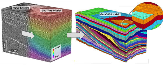
From seismic to accurate geocellular grid creation: an efficient workflow thanks to the GeoTime Model. © Eliis.
Several techniques have been developed to consistently represent layers of interest to subsequently fill the cells of the model with well-derived rock properties in order to perform geostatistical simulations. While some of the most recent techniques use stratigraphic flattening to overcome the complexity of the deformations for analysing the relationships between horizons and faults, others rely on stratigraphic age computation through implicit functions applied to unstructured meshing. Those methods alter and may even ignore the geometry of the geology, and do not necessarily guarantee accurate and controllable representation of the stratigraphic and structural organisation of the reservoir.
This article outlines a new method that allows the creation of a geocellular grid that strictly honours the geometry of the geology, while fully controlling the resolution of the sedimentary units targeted in the modelling.
Controllable and Iterative Gridding Method
The method to generate an accurate geocellular grid consists of three stages.
Definition of the architecture of the geocellular grid via a sequence stratigraphy tool. The type of geometry and the vertical resolution can be adapted for each layer and truncations can be created. © Eliis.
In the first stage, a semi-automatic interpretation of the seismic volume is performed to constrain and build a GeoTime Model (geochronological volume). This interpretation is automatically performed throughout the seismic volume based on the continuity of the signal to comprehensively constrain the geometry of the GeoTime Model, but the automatic solution is then locally refined by the interpreter to improve the GeoTime Model. The great advantage of generating a GeoTime Model lies in the possibility of defining geologically consistent horizons (or boundaries) everywhere in the volume and with virtually no vertical density limit.
In the second stage, the stratigraphic and structural architecture of the grid are defined. Based on the geometry of the GeoTime Model, the interpreter creates key boundaries between geological layers and stratigraphic units. Truncations may be applied to consistently honour stratigraphic unconformities such as onlaps and downlaps. Each layer can independently be subdivided into sub-layers, separated by sub-boundaries, to increase the vertical resolution of the geocellular grid. In each layer, several types of geometries can be applied to the sub-layers based on simple criteria. If the GeoTime Model has a high level of confidence at this location, the geometry of the model can be preserved. However, if the geometry of the GeoTime Model is not reliable in the considered layer – for example, due to a noisy signal or low amplitude – in order to allow for a synthetical, but geologically coherent organisation; the sub-layers can either be parallel to the top key boundary, parallel to the bottom key boundary, or iso-proportionally distributed between the two. The lateral resolution of the grid is freely determined, and structural discontinuities can be included as staircase faults.
In the last stage, the geocellular grid is generated based on those settings following a corner-point method: the vertical cell limits correspond to the position of the key boundaries and sub-boundaries; the lateral cell limits are vertical and their spacing is determined by the lateral resolution.
The geocellular grid can be exported in the standard Eclipse format compatible with the most commonly used modelling programs.
Interpreting a Giant Foreset Sequence
The results of this workflow can be illustrated by a case-study of the Maui block offshore New Zealand, which spreads over 1,000 km2 on the north-western edge of the Taranaki Basin. For this model five wells with gamma ray logs were used to populate the grid cells and simulate a rock property model.
Property Modelling from the gamma-ray well log on a geocellular grid of 382,690 cells from the Miocene-Pliocene giant foreset interval of the Maui block (offshore New Zealand). © Eliis.
The basement of the Taranaki Basin is defined as the rifted siliciclastic Cretaceous to Early Palaeocene series. From the end of Palaeocene regional post-rift subsidence allowed alternating deposition of non-marine to shallow marine sediments, creating gas-prone reservoirs and intra-formational shale seals, respectively. The series is overlain by Oligocene carbonates. The Lower Miocene sediments consist of basal siliciclastic sediments, evolving to giant foresets in the Late Miocene, which have been eroded and unconformably overlain by other normally faulted giant foresets at the beginning of Pliocene.
The application of geocellular gridding on this latter succession of Miocene to Pliocene giant foresets allows the generation of a grid with an architecture which consistently reflects the stratigraphic and structural organisation of the foreset series, involving both structural discontinuities like faults and stratigraphic terminations such as toplaps and onlaps. Although the integration of faults is still a basic staircase structure, the produced geocellular grid is outstandingly consistent with the structure of the geology. Hence, provided that the precision and density of the well data of the targeted area is accurate enough, this gridding technique is perfectly suitable to model the properties derived from well data.
A High Quality Geocellular Grid
The method presented here swiftly bridges seismic interpretation and reservoir modelling with the generation of a geocellular grid where the geometry of the geology is precisely delineated. The structure of the corner-point grid takes advantage of a GeoTime Model, iteratively refined through the seismic interpretation; hence, the geocellular grid offers the ability to preserve key geological details. The method also allows for the management of stratigraphic terminations and the control of the vertical resolution of the grid in each unit based on synthetical or GeoTime Model-derived geometry.
Thus, this technique delivers a high quality geocellular grid, a crucial starting point for the modelling of the reservoir properties.
Further Reading on Innovative Geoscience Software in Oil and Gas
One Step Closer to Fully Automated Fault Extraction in 3D Seismic Data
Sven Philit, Fabien Pauget, Sebastien Lacaze; Eliis, Caroline Guion; Eliis Inc.
To boldly go where no interpreter has gone before, getting one step closer to achieving the fully automated detection of faults in 3D seismic data.
This article appeared in Vol. 16, No. 1 – 2019
Artificial Intelligence and Seismic Interpretation
James Lowell, Peter Szafian and Nicola Tessen; GeoTeric
The key to all seismic interpretation is the interpreter’s experience and knowledge, so why should artificial intelligence change that? The reality is, it shouldn’t.
This article appeared in Vol. 16, No. 2 – 2019
Shaping the Future of Seismic Interpretation
Vianney Savajol, Eliis, Houston
A quicker way from seismic data to geomodel – or how seismic interpreters have finally come to the centre of the exploration workflow.
This article appeared in Vol. 14, No. 3 – 2017