Modern broadband imaging technology has rejuvenated legacy data in the Gulf of Mexico to delineate plays above and below the salt and improve imaging of known subsalt fields, enabling exploration for new nearfield discoveries.
Rejuvenated Seismic Reveals Flex Trend Plays
In an effort to provide high quality, fit-for-purpose solutions to the industry, PGS is rejuvenating its Gulf of Mexico portfolio with the goal of unlocking subsalt hydrocarbon potential in the shelf break Neogene play fairways. Though this area represents a mature basin segment, it still offers running room for capturing economically valuable reservoirs that are now better imaged in subsalt settings. Continued industry interest in this area has been demonstrated by lease sale participation over the last two years, followed by a recent uptick in drilling activity. Flex Trend experts, such as W&T and Walter and Fieldwood, have continued to explore and exploit nearfield opportunities at depths greater than 20,000 feet (6,000m).
Broadband Processing and Advanced Seismic Imaging Solutions
With this in mind, PGS is reprocessing 30,000 km2 of Flex Vision data to provide a contiguous, high-quality broadband depth dataset to solve the imaging challenges across the Flex Trend. The dataset comprises a series of 3D streamer surveys, acquired before much of the exploration and production infrastructure was in place, as well as several post-infrastructure ocean-bottom cable surveys. Together, these form a unique contiguous dataset along the shelf break of the Northern Gulf of Mexico, an area known as the Flex Trend. Re-mastering from the original field tape, followed by pre-processing, including full source and receiver side deghosting and designature and the application of the latest PGS demultiple flows, provides the ideal broadband input for depth imaging.
A detailed anisotropic sediment velocity model, built using Full Waveform Inversion (FWI), allows accurate interpretation of the top salt. Comprehensive salt scenario testing and subsalt tomography, calibrated to well information, generates a highly detailed and accurate velocity model above and below the salt.
Figure 1: Comparison of legacy Kirchhoff depth migration with the reprocessed Kirchhoff. The resolution of the new high frequency Kirchhoff is invaluable for viewing details in the shallow section. Shallow play fairways and seismic facies are more interpretable, with better resolution of faults and stratigraphy. Source: PGS.
The broadband Q-Kirchhoff depth product (Figure 1), with frequency content up to 90 Hz, accurately images the supra-salt section. The seafloor and very shallow section image was not imaged on the legacy data, whereas on the new data the entire shallow section is seen. Fault definition and the stratigraphy of the upper section are resolved such that potential oil plays are interpretable. The processing is fully AVO compliant with migrated gathers and angle stacks available for reservoir characterisation. The high resolution detail in the shallow section makes the dataset suitable for geo-hazard shallow gas mapping.
The final depth Reverse Time Migration (RTM) volume included image optimisation, modelled mode-converted wave attenuation and least-squares-based illumination compensation (Figure 2).
Figure 2: Comparison of legacy Wave Equation depth Migration (WEM) with the new Flex Vision RTM showing dramatic uplift in image quality in the deep section. Both large and small companies can improve their regional understanding of salt movement and structure as well as deep play fairways. Source: PGS.
New Potential Plays and Deep Geological Insights
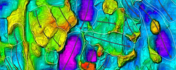
Figure 3: Top salt depth structure map with mapped Roho basins. The salt tectonics associated with these large systems has impacted structuring and sedimentation associated with hydrocarbon accumulations and reservoir quality. Source: PGS.
An assemblage of Neogene gravitational collapses – so-called Roho basins – dominate the subsurface architecture under the shelf break of the central Northern Gulf of Mexico (Figure 3). The Roho system is defined as a linked extensional-compressional system detaching on salt or a salt weld.
Roho basins kinematically balance up-dip extension and down-dip compression along low angle detachments, which usually reach Upper Miocene levels. Individual Roho systems may have different kinematic directions while interfering with neighbouring basins and result in complex salt geometries along their fringes. One consequence are multi-layered salt geometries formed by allochthonous salt derived from different Roho basins. The complexity of such salt bodies results from multiple deformation events, which may comprise episodes of salt flow alternating with extensional and compressional movement. Another aspect of these systems impacts the nature of salt keels as those have previously been considered to indicate massive salt feeders. This project implemented a Lean Salt approach, which keeps the salt volume at a minimum during model building. The underlying notion is that it is easier to add salt to an existing model than remove it once it occupies the volume.
Implementing this concept of salt model building resulted in seismic imaging that dramatically differs from the legacy data. It offers a powerful dataset for exploration adjacent to and beneath salt bodies and welds. The new anisotropic velocity field in the shallow section has accurately positioned reflectors below and against salt bodies (Figure 4).
Figure 4. Comparison of legacy WEM with Flex Vision RTM showing repositioning and improved imaging of known oil accumulations within the yellow ellipses. Source: PGS.
The high frequency RTM volume images the Miocene play fairways and clarifies the Miocene and the deeper potential in the Lower Tertiary. A structural version of the RTM is available that enables mapping of sediments terminating against salt walls and the structure of the deep section below 40,000 ft (12,000m), giving regional context and geological understanding.
The broad structural and depositional framework for the deep section will help the understanding of the Paleogene and older systems as the depositional systems transit this seamless 3D volume from north to south into the prolific deep water of the Gulf of Mexico (Figure 5).
Figure 5: Comparison of legacy WEM with Flex Vision RTM illustrating how the new product allows mapping of Paleogene and older systems down to 40,000 ft. These rejuvenated data will be instrumental in improving industry understanding of these systems and giving explorers an edge over their competitors. Source: PGS.
A Comprehensive Dataset
Figure 6: The reprocessing phases of the Flex Vision. In total, more than 30,000 km2 of data will be rejuvenated with modern broadband processing sequences. Source: PGS.
The Flex Vision programme delivers a comprehensive and geologically conformable dataset in complex salt architecture. Innovative concepts of salt model building are implemented which significantly improve the imaging of potential reservoir sequences trapped either against salt flanks and overhangs or in subsalt settings of primary mini basins.
Final products for Phase 1 covering 4,000 km2 are available now and Phase 2 (3,000 km2) will be available in July 2019. (Figure 6). Early out for Phase 3 (10,000 km2) will be available in September 2019.