An analogy with bat technology makes it easier to understand seismic imaging of the subsurface. However, a bat’s sounds transverse a homogenous medium, while seismic waves in the earth are…
“Sound waves from seismic data acquisition resulted in increased catches for some species and smaller catches for others.” To me, that sounds a bit inconclusive, but it is still the…
So, the Macondo well has finally stopped leaking and should be permanently sealed by the end of September, nearly five months since it first suffered a major blow-out. This has…
Ken Glennie, Honorary Professor of Geology at Aberdeen University and renowned author of three books, several co-edited publications and over 50 single-author and co-authored papers, has led the sort of…
Seabed samples from the Baffin Bay document an active hydrocarbon system offshore northwest Greenland. The northwest Greenland shelf is a frontier petroleum province in the arctic Baffin Bay. Limited seismic…
Tron Kristiansen, Olav Barkved, Martin Landrø and Lasse Amundsen
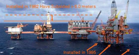
This article discusses the linkage between 4D seismic responses and geomechanics. Exploitation of this relationship has helped reduce development costs and maximize recovery from the compacting Valhall reservoir. The 4D…
Offshore Electromagnetic surveying, CSEM, was commercialized in 2002 as a new exploration technology for finding hydrocarbons. Following some seven years of trial and failure, we have asked one of the…
Permanent seismic monitoring is an emerging market with significant potential. Who are the major players and what has been done to validate the Optowave technology? This article has been designed…
Fibre optic sensing technology offers the potential for a cost-effective, reliable reservoir monitoring system as an alternative to seismic systems based on electronics. Interested in learning about fibre optic seismic…
Fred Aminzadeh, Past President, Society of Exploration Geophysicists and Larry L
The use of geophysical methods in petroleum exploration continues to expand and is an integral discipline in the discovery and production of oil and gas deposits. We have seen a…
The main purpose of applying EM data is to improve exploration decision making. “As a geoscientist working in an oil company which values integration, we try to maximise the use…
Professor Erik Flekkoey, University of Oslo and Petromarker a/s
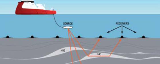
Electromagnetic surveying is one of the least well understood of the non-seismic exploration techniques. There are various acquisition choices to be made – for example it can be undertaken using…