The Regional Deep Imaging Project (RDI) by MCG and Geoex is a 2D seismic multi-client project that aims to improve imaging of large-scale, deep-seated crustal structures in the Norwegian Barents Sea, the Norwegian Sea, and the North Sea.
The Regional Deep Imaging Project (RDI) by MCG and Geoex is a 2D seismic multi-client project that aims to improve imaging of large-scale, deep-seated crustal structures in the Norwegian Barents Sea, the Norwegian Sea, and the North Sea. The RDI Project started in 2018 and currently consists of 7,700 km of regional long-offset 2D data. In 2021 the plan is to acquire additional 12,000 km in the North Sea (NCS and UKCS).
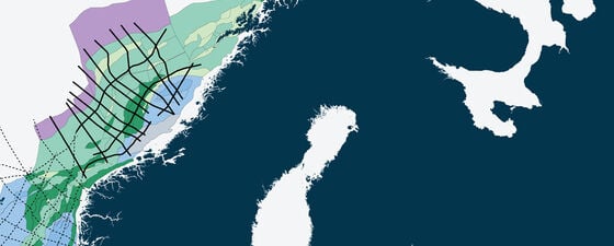
The Regional Deep Imaging Project covers the Norwegian Barents Sea, the Norwegian Sea and the North Sea.
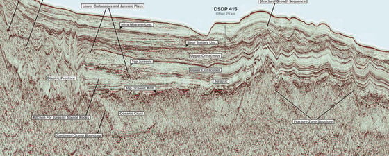
With the RDI dataset oil companies will be able to interpret large-scale tectonics as well as Moho and basin geometries. This will increase the understanding of the heat flow and serve as valuable input for basin modelling. The data is acquired using longer offset and record length than existing data. The seismic lines are between 100 – 600 km long and will, when finalised, cross borders between Norway, UK, Faroe Islands and Denmark. To obtain an even better control of the main structural elements and the depth to the Moho, gravimetry and magnetic data are also being acquired.
The RDI19 program comprises 5,600 km in the Norwegian Sea. The data is in the final stage of processing and will be ready for delivery in mid-June 2020. The focus in the processing has been to enhance the image of the crust, but also to image the deposited sediments.
Contact MultiClient Geophysical (MCG)
For more information about the RDI Project, please get in touch with MCG at info@mcg.no