
The world’s first combined, simultaneously acquired ultra-high density streamer and node MC3D survey
Geoex MCG and Seismic Partner initiated the Quad 35 project in the winter and spring of 2020 and formed partnerships with several service providers to both financially and operationally realize the project. The UHD streamer acquisition was performed by BGP, ocean bottom nodes were delivered by Magseis Fairfield and deployed and recovered with ROV by Reach Subsea, and the data processing was done by Downunder GeoSolutions (DUG). The Quad 35 MC3D Hybrid survey was acquired between August and October 2020 with the final processed data being ready in July 2021.
The new Quad 35 MC3D survey data has significantly improved the imaging of the Upper Jurassic sands and the complex faults for which this area is known. The data is ideal for the oil companies that are developing existing discoveries and for companies that are looking for additional resources close to existing infrastructure.
Why Quadrant 35?
Quadrant 35 is located immediately downdip of, and in the migration pathway of, the world class Troll accumulation, believed to have reserves in the order of 1,766 Mbbls Sm3 oil equivalent. This is by far the biggest accumulation on the Norwegian Continental Shelf (NCS). This suggests that the area has access to enormous amounts of migrating hydrocarbons. Almost every valid fill and spill trap on the migration fairway from the basins to the Troll field has been found to be hydrocarbon bearing.
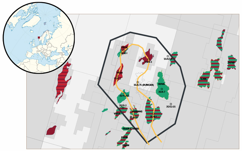
the area covered by the Quad 35 survey is therefore known to be hydrocarbon rich and contains several discoveries (Nova, Vega, Aurora, Grosbeak, Byrding, Beaujolais, Orion). Figure 2 shows a long arbitrary line going through many of the discoveries. Several of these are in the process of being developed. In addition, the increased focus on near-field exploration has made this area very attractive for new and improved seismic acquisition and imaging technology.
Prior interpretations of existing data covering this area has proven to be challenging, because of imaging difficulties due to complex overburden and faulting.
Exploration targets and challenges
The main exploration target in the Quad 35 area is Jurassic and as in the Troll field, Upper Jurassic sandstones play a major role, mainly due to their large quantities and role in the migration fairway. In addition, the Middle Jurassic is trapping significant hydrocarbon accumulations. Although Lower Cretaceous sandstones are proven as a trap to the north-east of the survey area, it remains to be proven within the acquired data. This new data paves the way for a fresh and closer look for accumulations in the Lower Cretaceous.
The main challenges historically in the Quad 35 area have been to understand the Upper Jurassic sand distribution, erosion and sealing faults, and the imaging due to a complex overburden with associated velocity anomalies. All those issues have been addressed and significantly improved through the hybrid LumiSeisTM solution used to acquire this project.
The Solution – Hybrid Streamer and Node Acquisition – LumiSeis™
Historically, the seismic node and streamer industry have been working on separate fronts to improve their solutions, while competing for the same markets. The Lumi SeisTM hybrid concept from Seismic Partner has been developed on the basis that none of these technologies are ideal on their own. The hybrid concept aims to combine and jointly harness the potential of these two proven methodologies.
Geophysical modelling of the Quad 35 area was performed to find out how to solve the imaging challenges. The conclusion was that very high-density data with many near offsets, to improve the signal-to-noise ratio, and the best possible velocity model by use of Full Waveform Inversion (FWI), were needed. Geoex MCG and Seismic Partner therefore decided to use the LumiSeisTM acquisition technology to improve the imaging. LumiSeisTM is an optimised combination of streamers and seabed nodes. This unique approach has allowed all the data in this hybrid project to be acquired simultaneously and with the same source, resulting in an efficient acquisition, both operationally and cost-wise, ensuring high quality data with a competitive price.
The node data was used to define an improved velocity field through FWI. This velocity field was then used to improve the migration of the ultra-high density (UHD) streamer data. The hybrid method also allows summation of the UHD streamer data with the node data. This in turn will provide better imaging of the subsurface, unlocking new opportunities in exploration and production.
In addition to the hybrid acquisition technology, the survey was also acquired in an optimal strike direction to the main faults.
Hybrid LumiSeis™ Acquisition – The Geophysical Reasoning
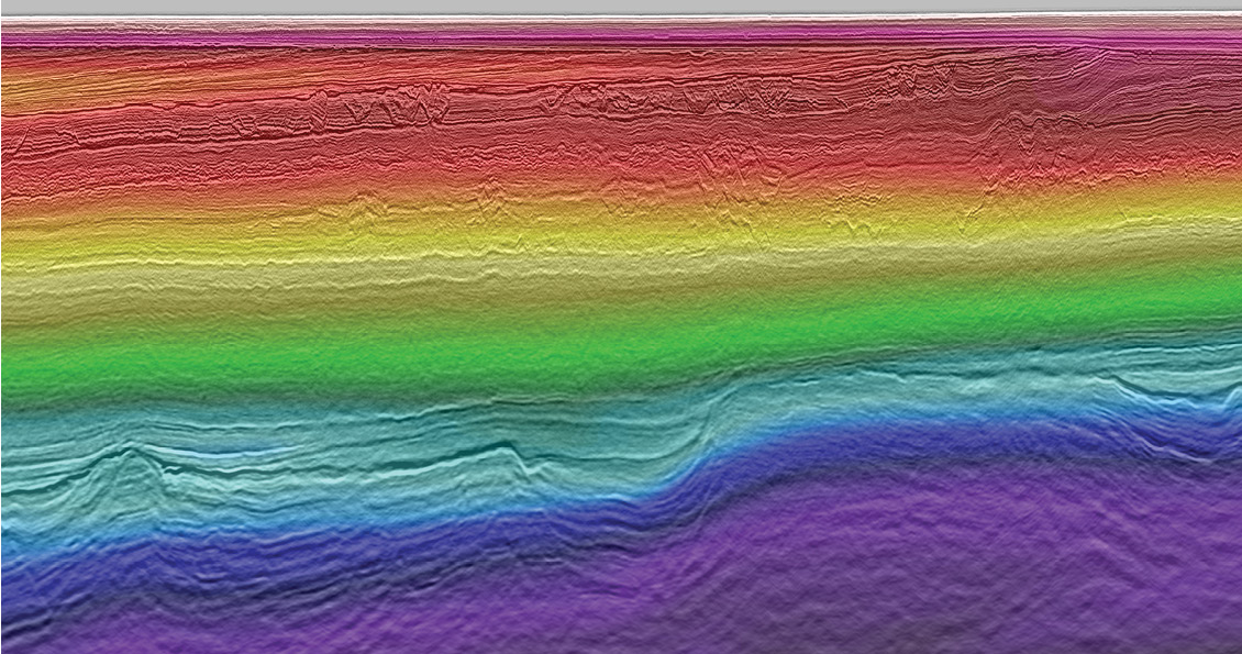
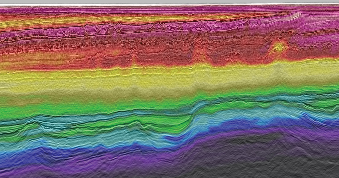
The geophysical reasoning for acquiring ultra-high density streamer data together with node data is simple and sound: the high-resolution data from the dense streamer dataset is focused and placed correctly in depth by the better velocities derived from the OBN dataset. The acquisition set-up gives ultra-high fold data, which boosts the signal-to-noise ratio and thus higher frequencies are recovered at depth as compared to existing high-end surveys. It also offers smaller grid bin size which leads to increased lateral resolution. The velocity model benefits from the high-fold and good near-offset coverage from the streamer data in the shallow, and the longer offset data from nodes in the middle to deep parts of the section. The FWI velocity model updates using both streamer and OBN datasets to give a very detailed velocity model. Conventional velocity models derived from reflection data are good at flattening events but lack detail and accuracy. Offsets up to 15 km from the node data were used to drive the deeper velocity model updates using FWI. The net result is a detailed velocity model that puts data in the right place after imaging. Figure 3a and Figure 3b shows how the detailed FWI velocity model improves the imaging below the complex overburden. The final velocity model includes anisotropy and produces an excellent correlation with the wells in the area.
The streamer survey was designed to produce a well-sampled source grid, exposing the nodes to data from all azimuths and offsets. Simultaneous acquisition of streamer data and node data meant that no extra source effort was needed. With this benefit, the timeframe and level of underwater sound emission was limited. This contrasts with current methods for acquiring node data, where duplication of source effort is the norm.
The hybrid acquisition can yield several datasets which each have their merit:
- A stand-alone high resolution streamer dataset, with similar quality to site surveys in the shallow
- A stand-alone OBN dataset, using for example mirror migration and RTM
- A detailed FWI velocity field from both streamer and node data
- A correctly imaged ultra-high density streamer dataset using the FWI velocities
- A blended streamer/OBN product
- A shear wave product
This means there is still more potential in the acquired data by also utilising the OBN data for imaging.
Results and future plans
The final Quad 35 data shows superior imaging compared to other data covering the Quad 35 area. The dataset will play an instrumental role in positioning development wells as well as assisting producing assets in identifying near-field exploration targets. The hybrid acquisition method has shown to be extremely effective in imaging the Quad 35 geology, while also proving to be applicable in other geological settings.
With the successful completion of the Quad 35 survey, Geoex MCG and Seismic Partner are already planning more hybrid acquisition projects in the years to come. In conclusion, this method produced the next level of imagery that the exploration industry has been asking for.
Note: the resolution in the main seismic line (Figure 2) has been reduced for online publication; to help avoid slow page loading times. You can view the original on pp65-68 of the printed edition of GEO ExPro Vol. 18, No. 5 (also available in PDF).


