Remember dumping 1,000 varied shaped and colored pieces on a big table and then trying to put it all back together to match the picture on the box? One person could concentrate on the blue and white pieces that match the sky; another person could put together the greens and browns of the animals and the pasture; and yet a third could concentrate on the red and white shapes that make up the barn. By sorting the colors and fitting pieces together, a picture would gradually come to life on the tabletop.
Now, imagine having even better 3D capabilities with a complex reservoir 3,000m below the surface. This is the goal of a prototype tabletop interactive reservoir visualization program being developed at the University of Calgary.
Hands On
“We have attempted to harness the power of digital tabletops into a new interaction paradigm – bringing the reservoir to hand’s reach,” says Nicole Sultanum, a researcher at the IllustraRes – the University of Calgary’s Interactive Reservoir Modeling and Visualization Group, affiliated with the Department of Computer Science. “The aim is to facilitate collaborative manipulation and analysis, and potentially contribute to the overall understanding of the reservoir.”
Their prototype utilizes the new technology of digital tabletops to provide a suitable form factor for collaboration into the very complex and multi-faceted field of reservoir engineering. Any single project incorporates many threads of knowledge from geoscientists, engineers, and economists to achieve production goals while maximizing return. This all has to be accomplished while maintaining the integrity of the production installations and wells, and guaranteeing a safe operating environment.
Companies have commonly utilized teams of experts and immersive virtual reality environments for reservoir visualization. While this type of shared view of the reservoir does facilitate analysis, it does not allow for the easy multi-user interaction that the digital tabletop can provide.
“Revolutionizing the way reservoir models are seen, understood and harnessed… bringing it closer to us, at our hands’ reach”
How It Works
“The unique capabilities of the tabletop environment provide better ways to manipulate reservoir models, from basic activities such as spatial navigation and probing, to the ability to browse and inspect the reservoir through direct, intuitive manipulation,” explains Nicole.
In evaluating reservoirs, geoscientists and engineers deal with rock and fluid properties like porosity, permeability, saturation values, and changing fluid properties as oil or gas is extracted. Wells and geologic features are also important to reservoir modeling. However, this important data can remain hidden without mechanisms to uncover, depict, and highlight.
“We have developed a set of interactive tools on the tabletop that facilitate the unveiling of the reservoir’s hidden attributes, at the same time allowing users direct access to essential reservoir information,” says Nicole. “The tools include a cell probing device, the capability to split pieces of the reservoir and peel them out to reveal correlations between adjacent sections, and to highlight wells. Specialists using these tools are able to look at data that has been previously ‘buried’ in the reservoir model, which potentially contributes to more informed decisions concerning its production.”
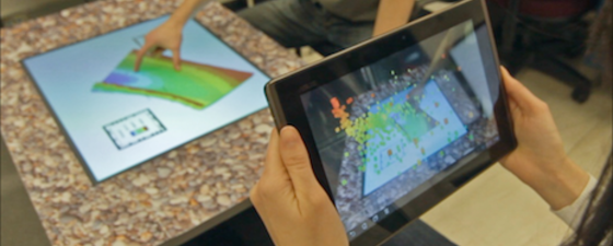
Besides the internal exploration techniques depicted across the pages, users have a reservoir model selection menu with physical reservoir property cards. These are activated when placed on the screen and can perform a variety of spatial navigation functions within the reservoir such as orbiting, zooming, rotating, and panning. Another goal is to create an interactive and visual environment to probe deeper into different views of the reservoir model. Allowing multiple users to view and manipulate multiple perspectives of reservoir datasets, visualizations can be overlain above the tabletop reservoir through mixed reality, utilizing tablet devices as windows to the virtual view. The tablet’s onboard camera is used to detect its orientation and position relative to the tabletop by tracking special image-based markers positioned around the device – the markers do not disrupt the tabletop interaction, allowing multiple users to collaborate while working on the same reservoir.

Some of the internal exploration techniques that have been developed for the tabletop:

(A) cell probe displaying cell-specific information. Source: Nicole Sultanumrntttt(B) splitting. Source: Nicole Sultanumrntttt(C) peeling. Source: Nicole Sultanumrntttt(D) focus and context for wells.. Source: Nicole Sultanum


Testing and the Future
To see if this new tabletop environment will be of value to geoscientists and engineers, the researchers let them test it. Requests for improvement to the technique centered on two concepts: control and correlation. Participants needed more precision and control within multi-touch environments, which was a reflection of the meticulous nature of their work. The second recurring concept revolved around the ability to compare or correlate two or more properties and visualize several layers or models, among others.
The list of changes and improvements is included with all the techniques they have introduced here and are important when designing future systems. ”Participants in the tests were engaged by these tools and were eager to share their thoughts and insights regarding each,” says Nicole. “Our impression was that such a creative environment can add and facilitate the thought and problem-solving process. As one of our testers put it, ‘It actually brings some new ways of analysis… (and) creativity for sure’.”
Current and future development involves further exploration of other techniques for the tabletop environment, such as the visualization of uncertainty, sketch-based interaction, and the integration with robotic tabletop assistants to support the users’ work of analysis. As Nicole Sultanum points out, “We hope to bring the tabletop environment’s many strengths to light, not only for reservoir engineering but beyond to demonstrate their potential to transform the ways humans explore scientific data.”
Author’s note: The work presented here is a collaborative effort between Nicole Sultanum, Sowmya Somanath, and Paul Lapides, guided by supervisors Ehud Sharlin and Mario Costa Sousa at the University of Calgary.


