
A paradigm shift in data imaging
Accurate velocity and reflectivity models are essential for high-fidelity seismic interpretation.
Full Waveform Inversion (FWI) followed by Least-Squares Migration (LSM) is currently the high-end technique to invert for high-resolution velocity and reflectivity models. However, in a traditional sequential workflow, velocity and reflectivity are inverted separately and leakage between the two parameters is unavoidable.
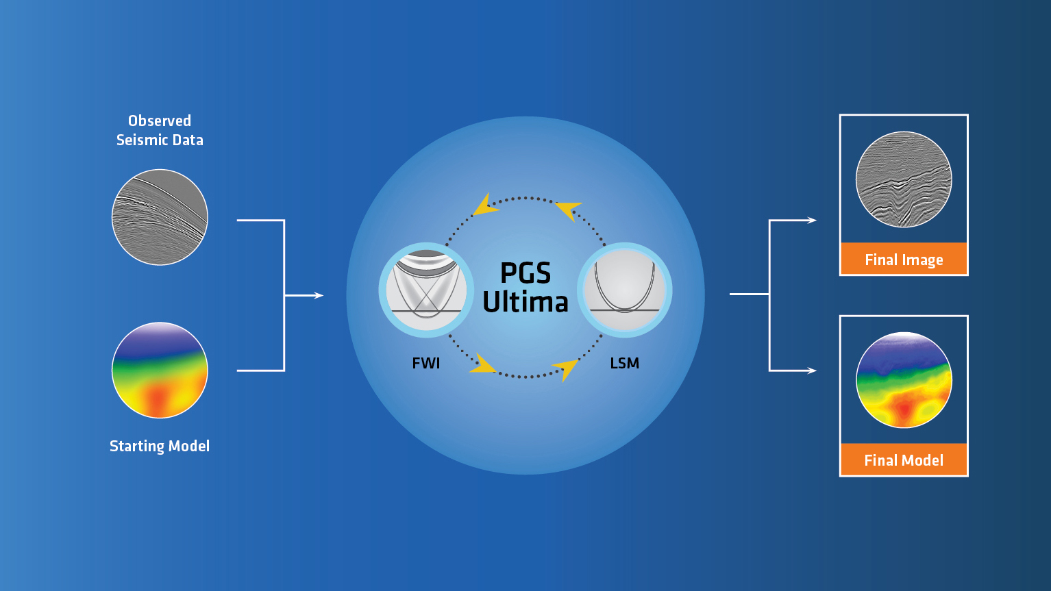
FWI and data domain LSM share a similar framework, both aiming to minimize the misfit between modeled and recorded data. Accordingly, it is possible to solve both problems in a compact framework. PGS Ultima implements FWI and LSM in a joint scheme. The inversion scheme updates both velocity and reflectivity simultaneously at each iteration as summarised in the inversion workflow as shown in the figure above.
PGS Ultima has the potential to reduce the turnaround time of a project as only a starting velocity model and minimal pre-processed data is required. A robust inverse-scattering image condition can efficiently separate the velocity and reflectivity updates and minimise the leakage between the two parameters.
The output of PGS Ultima is a high-resolution velocity model together with an accurate estimate of the earth’s reflectivity with compensation for incomplete acquisition, poor illumination, and multiple crosstalks. Additional derivative properties such as relative density and relative impedance can be estimated directly from the inverted models.
Derisking leads
The method was successfully applied to a dataset from offshore Newfoundland and Labrador. The resulting outputs deliver good amplitude fidelity and signal-to-noise ratio. The inverted models can be directly used to identify leads and reduce the risk when identifying prospects. The narrow azimuth (NAZ) 3D survey used for this study was acquired in 2020 using multisensor technology with 16 streamers, 100 m streamer separation and 8 km streamer length.
Of particular interest in this area are large-scale Paleogene marine fan systems that align along the shelf margin off the northeast Coast of Newfoundland. In this shallow water setting the main imaging challenges are multiples and strong velocity contrasts which make it difficult to identify prospects as the signal-to-noise ratio (SNR) is poor. The uplift from applying PGS Ultima to the data improves the identification and understanding of such prospects within the Blomidon survey.


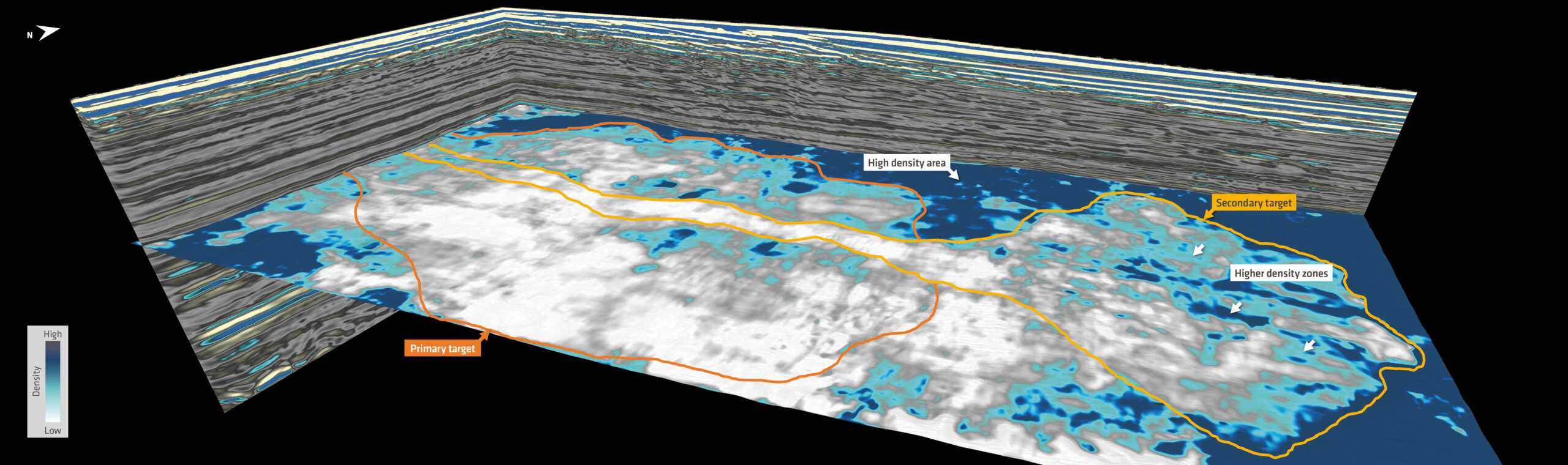
The top image in the figure to the right is the relative impedance property extracted at the target interval. There are two potential reservoir fairways shown on the map. Both are notionally interpreted as marine fans. The primary target (orange outline) was delineated using the underlying data but PGS Ultima was able to improve the image in the distal part where a secondary fan feature (yellow) has become more apparent. This is thanks to the increased signal-to-noise ratio at low frequencies and more accurate velocities. Both the primary and secondary fan features have encouraging low relative impedance responses (light gray). Lateral heterogeneity is seen within the secondary fan, note the variation of the dark (harder rock) and light (softer rock) colours.
An overlay of the relative density map and the relative impedance is shown on the bottom image of the figure to the right. The joint interpretation of both attributes confirms the delineated secondary fan geometry and the relative density attribute provides additional insight. A higher relative density signals a change in the reservoir property or a different fluid phase in the distal part of the secondary fan feature. Revealing such details is important for risk mitigation in the Orphan Basin.
A reliable solution
Traditionally, it has been difficult to produce a reliable density attribute as final and fully processed very high angle stacks (above 45 deg.) with a good signal-to-noise ratio would be required. This would mean that the exploration team would have to wait until the end of the data processing phase, which normally takes several months. Sometimes the duration of the processing phase overlaps with the bid round schedule and puts exploration teams under pressure to meet deadlines.
PGS Ultima can help in these situations. It is a fast data-driven approach that delivers direct estimates of the subsurface velocity, reflectivity, and their derivatives, relative impedance and relative density. Depending on the geological setting and the target level, it can even start from minimal pre-processed input data and can be run very effectively, enabling the technical teams to perform prospectivity and lead risk assessments in a shorter time frame.
All images courtesy of PGS.


