In the second decade of the twenty-first century, competition for exploration targets is increasing. Most energy companies are now faced with the need to explore for hydrocarbons in difficult environments such as ultra-deep water or complex geological settings that have technical risks such as very high temperatures and pressures. An exploration well in such environments can potentially cost $100 million or more and take many months to drill. Understandably, companies want to maximise their investment by drilling discoveries, not dry holes.
In the latter part of the twentieth century, most hydrocarbon exploration used a combination of geology and seismic. In the past decade, however, a number of new technologies have been developed as a complement to traditional seismic interpretation and to further reduce exploration risks. One of these is Controlled Source Electromagnetic surveying (CSEM), which detects resistive layers in the subsurface that are embedded in conductive sediments (e.g. hydrocarbon fill of reservoirs bounded by brine-saturated layers). CSEM can detect hydrocarbon fill directly but has low resolution and can be a relatively expensive and time-consuming technique, usually requiring a dedicated vessel and the emplacement of detectors on the sea bed.
In 2012, a Norwegian company, Offshore Resources Group Geophysical A.S. (ORG), was set up by a group of ex-oil company staff and academics with the intention of adding a new, but less complex and costly technique to the de-risking portfolio available to hydrocarbon explorers. ORG formed a partnership with a Russian company, Siberian Geophysical Research and Production Company (SGRPC), which had been using a technology called Differentially Normalised Method of Electrical prospecting (DNME) based on Induced Polarisation (IP), an electrical survey method often used in the mining industry to detect ore bodies. SGRPC had developed this technology to locate pyrite bodies that are formed over time above hydrocarbon accumulations.
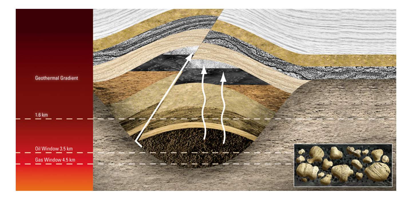 The slow micro-seepage of hydrocarbons gives rise to mineralogical changes high above a reservoir. (Source: ORG)
Pyrite as Hydrocarbon Indicator
Eirik Flekkøy, Chief Scientist of ORG and also a Professor of Physics at Oslo University, explains the importance of pyrite. “There are several mechanisms leading to the induced polarisation effect. A key one is the formation of pyrite. This can be through direct chemical reactions between sulphur in micro-seepages from a hydrocarbon reservoir and pre-existing iron in the rock, or indirectly via the degradation of ‘oil-eating’ bacteria. These are both hydrocarbon indications.” So the DNME technique does not try to detect hydrocarbons in a reservoir several kilometres deep, but to see much shallower evidence for the presence of the deep hydrocarbons, with the pyrite bodies possibly only a few hundred metres below sea bed or ground level. As Eirik says: “It’s like looking for a tropical island on or below the horizon which is hard to see, whereas the cumulus cloud above it is relatively easy to observe.” SGRPC has acquired 35,000 km of data in Russian areas since 2002 and claims 90% success rate in their predictions of nearly 200 wells.
The DNME technology relies on inducing polarisation in the pyrite bodies with electrical signals. IP is in fact a delayed electrical response. Eirik continues: “It’s like the effect you see in a battery. When a current is applied, it takes some time for the battery to be charged. We then look at the voltage decay after the current is turned off. When the current is applied and then shut off, in the pyrite grains, at pore scale, there is a chemical reaction that is similar to what happens at the electrodes of a battery when charging and discharging it.” The amount of over voltage when ‘charged’ is a measure of the IP effect. The voltage decays to a certain level in a certain time (the relaxation time) and the method also characterises the shape of the decay.
Simple Low-Cost System
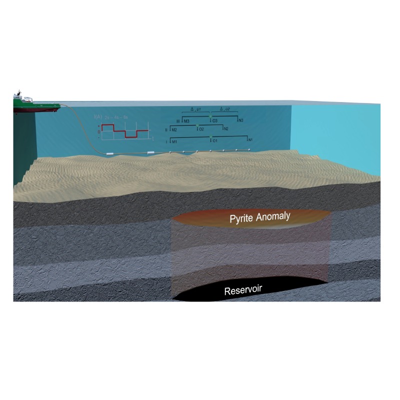 Pyrite forms above a hydrocarbon reservoir as a result of micro-seepage. A vessel towing source and receiver electrodes can induce polarisation in the pyrite and record the resultant distinctive signals. (Source: ORG)ORG has taken the Russian technique and adapted it to its own backyard, offshore Norway. The shallow nature of the target means that the equipment required for surveys can be kept at a modest level, reducing costs. In fact the whole package can be put into three 7m shipping containers and placed on a workboat when surveying offshore – it is not necessary to have a dedicated vessel. The whole system is towed, with a transmitter with two electrodes separated by 600m, the first one only a few tens of metres from the vessel. The detectors are a set of electrodes spaced 200m apart and organised into three sets of three electrodes that can each measure potential differences and electric field gradients at different offsets. The depth of tow is from 50 to 500m depending on targets and operational conditions and the system is towed at about three to five knots (about six to ten km/hr).
The signal is a step pulse that is switched on for typically four seconds, then off for the same period of time, then repeated with the opposite polarity in order to average noise. Because the targets are shallow, signal-to-noise is not usually a problem as the returned signals are still above background levels. Signals are also normalised to correct for offset differences.
The signals are processed using inversion based on the formulation called the Cole-Cole expression for electrical conductivity. This defines a relationship between electrical conductivity, σ, and the ‘chargeability’ or ‘polarisability’, η. Two other parameters in the relationship are the relaxation time, τ, and an exponent that can be derived from the decay shape. The measurements are inverted in an iterative manner for resistivity and chargeability in layers that have been defined using seismic or well logs and η (eta) is derived as a percentage value for the shallow pyritised layer.
Norwegian Testing
During 2012 and 2013, ORG conducted a number of test surveys in Norwegian waters across known hydrocarbon fields in order to see if the method was suitable for use in these areas. Over 3,500 line km have been surveyed across 20 fields, 18 of which gave results that corresponded to known drilling results, while one measured anomaly in chargeability was offset from the field and the results of one other are as yet unexplained. Reproducibility tests were also conducted, one in 2012 re-acquiring a line with a less than 1% difference from the original, while further tests of the same line in 2012 and 2013 gave very similar results. The 2013 survey used equipment that had been improved based on the 2012 experience and was judged to give better resolution.
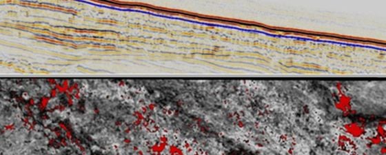
One of the surveys conducted in 2012 was across the Frigg area where the six lines surveyed showed ‘eta’ anomalies above three reservoirs, two in the Jurassic (oil and gas) at around 3,000m+ reservoir depth and one Tertiary oil reservoir at 1,900m depth. A known dry well that was crossed did not have any anomalies associated with it. Similar results were obtained on most of the other fields covered, including the Troll area. As a result of the positive tests, a multi-client survey with eight oil companies was conducted in 2013 in the Norwegian North Sea. Of the seven predictions made as a result of the survey, six have been confirmed as correct. Five of these were discoveries and in one case a dry well was predicted. In 2014, dedicated commercial surveys are due to start, with a typical 200 km survey having some £500,000 ($675,000) acquisition cost, including technical and weather risks.
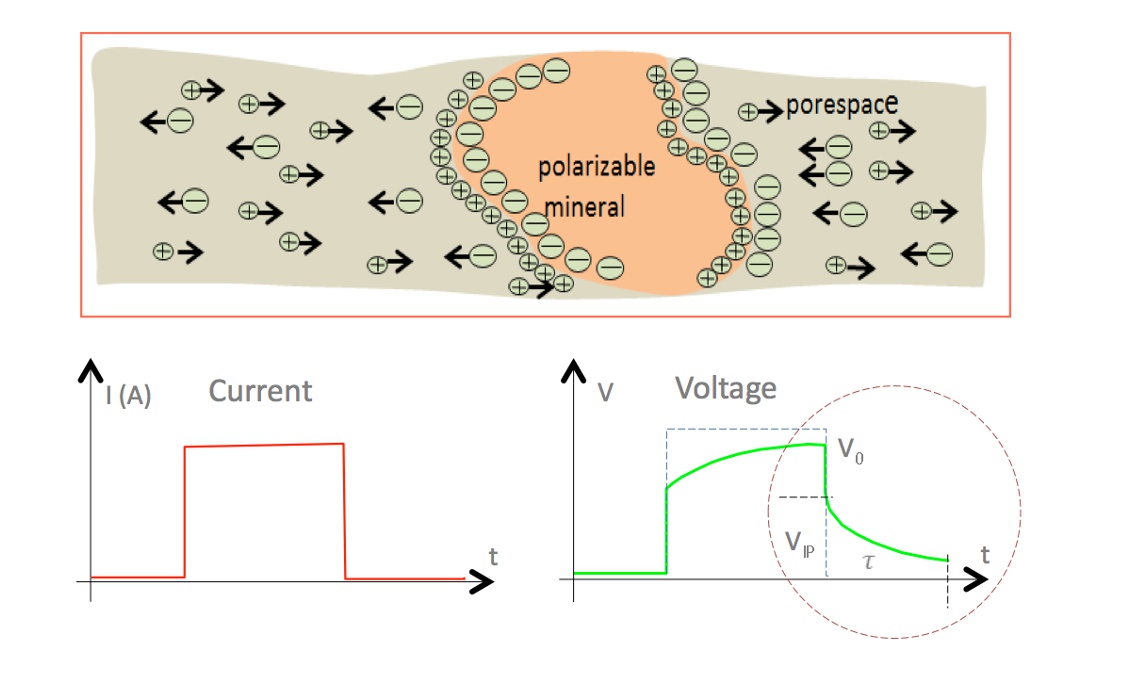
Polarisation occurs in a pyrite grain when a current is applied. The voltage builds up as in a battery and then decays when the current is switched off. (Source: ORG)
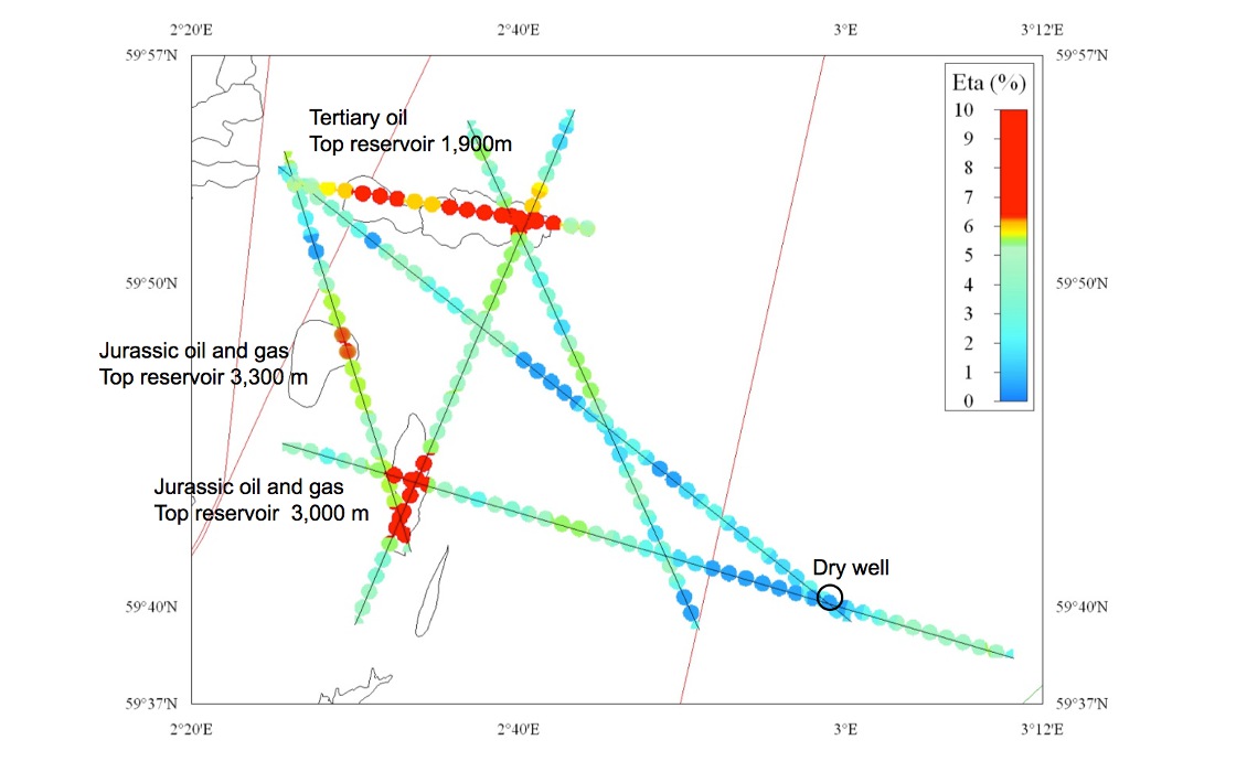
DNME survey across the Frigg Field, offshore Norway showed anomalies above three known reservoirs and no anomaly across a dry hole. (Source: ORG)
De-Risking Potential
The tests conducted in Norwegian waters showed that, at least here, this new technology based on well known principles has the potential to locate, quickly and relatively cheaply, hydrocarbon accumulations that may not be found using conventional exploration techniques, even in well explored areas. There is a clear potential to target stratigraphic traps that may not be readily detectable on seismic data. It may not work everywhere, for example where prospects are sub-salt or there has not been any micro-seepage, so should be tested before entering new areas. It also does not detect hydrocarbon reservoirs directly, and therefore should be seen as a complement to existing techniques. However, the method shows promise as an initial low-cost screening tool before planning more detailed focused work using techniques such as CSEM and 3D seismic.


