
Uruguay is a frontier area in terms of hydrocarbon exploration, but now the exploration spotlight has focussed on this region with the announcement of Uruguay’s second offshore licensing round.
Perfect Atlantic analogues
Offshore Uruguay is still regarded as an exploration frontier region, but is considered to have a wealth of hydrocarbon potential.
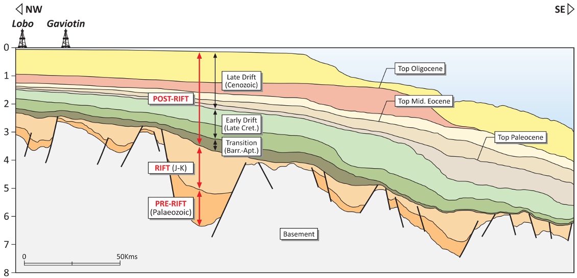
Limited offshore exploration occurred in Uruguay during the mid-1970s, resulting in two exploration wells, Lobo and Gaviotin. These were drilled on structural highs within the Punta del Este Basin in very close proximity to each other and in relatively shallow waters. The results were disappointing as both wells were declared dry. Critically, however, there were inclusions of oil and gas shows, indicating the possibility of a working hydrocarbon system.
Drilling exploration ceased during the 1980s and since then exploration has been limited to the acquisition of a number of seismic surveys, including Spectrum’s 2002, 2007 and 2008 surveys. However, the presence of hydrocarbon shows maintain the belief that there is a regional working hydrocarbon system and that the offshore area may deliver the next world class high impact hydrocarbons.
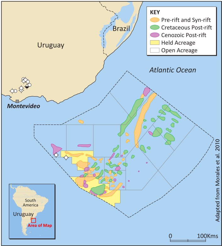
Three offshore basins
During the Permian and Triassic, Western Gondwana divided as a result of crustal extension, then during the Jurassic and Early Cretaceous the South Atlantic Ocean opened, due to dextral strike slip movement, initiating a triple junction. Prior to the break up, South America and Africa were joined and therefore the West African and Latin American east coast margins consist of a transform margin, characterised by a series of discrete on and offshore Mesozoic-Cenozoic basins.
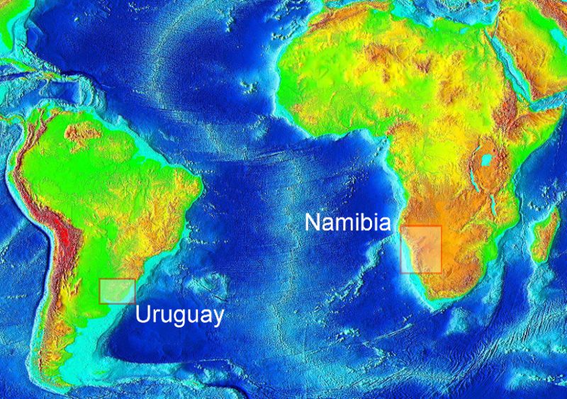
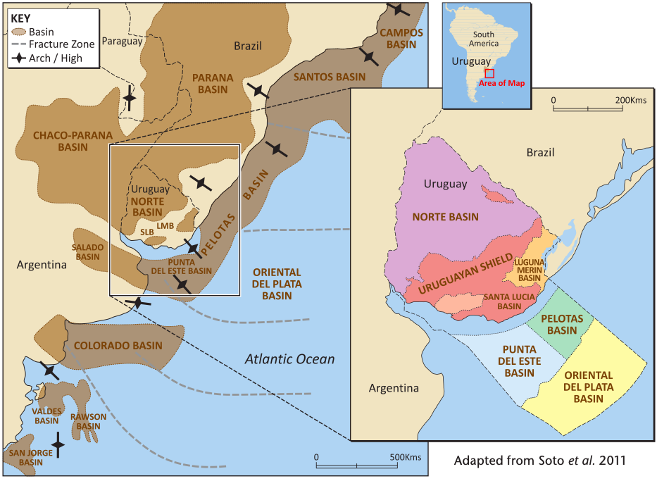
Uruguay has six main sedimentary basins, three of which are offshore: Punta del Este, Pelotas and Oriental del Plata. The offshore basins lie on trend with the prolific hydrocarbon-producing Argentinean San Jorge and the Brazilian Santos Campos Basins and on a conjugate margin with Namibia, where the Kudo gas field is located. Offshore basins cover a total area of 80,000 km² extending up to 370 km offshore, with water depth varying from 20m to over 4,000m.
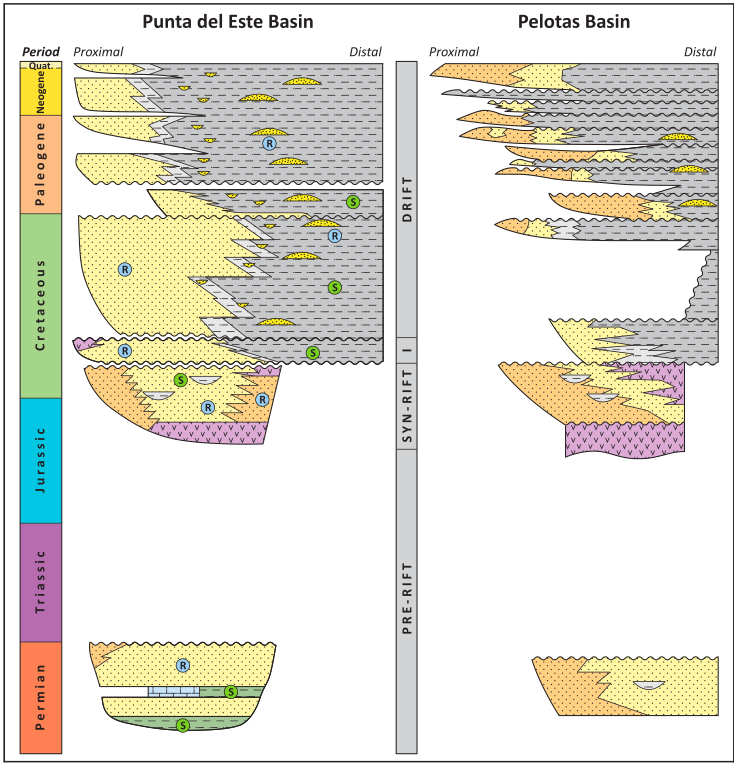
The Punta del Este Basin has four main tectonic stratigraphic stages: the pre-rift during the Permian, syn-rift in the Jurassic and Early Cretaceous, a transition period through the Hauterivian Aptian and drift through the Aptian to present day. The Pelotas Basin extends from the Polonio High to the Florianopolis Fracture Zone in Brazil, where the Santos Basin commences. The pre-rift sequence can be interpreted as an analogue to the Brazilian area, where it is shown to correspond to the Paleozoic and Mesozoic units of the Parana Basin.
The third offshore basin in Uruguay is the ultra deep water Oriental del Plata Basin. It consists of Cretaceous and Cenozoic marine sequences, comparable to the Argentine Ameghino Basin.
Promising petroleum systems
It is important to review the regional context of the petroleum systems to enable a better understanding of Uruguay’s offshore geology. Both the Orange Basin in Namibia and the Santos Basin in Brazil are examples of almost perfect analogues in petroleum system terms, and these systems can be extrapolated into offshore Uruguay. Both regions demonstrate lacustrine and marine source rocks with similar oil type and comparable reservoir depositional environments. The traps in the basins are associated with basement highs and the areas have vertical migration pathways with normal fault pathways to provide carriers.
Hydrocarbon-prone Aptian rocks are thought to be the primary source rock and have been identified and mapped throughout the offshore Uruguay continental margin. The Aptian source rocks play a vital role in the working petroleum system of the conjugate margin, offshore Namibia, particularly in the Orange Basin, where, as well as the main source rock, the Aptian sequence also provides the high quality reservoir sands found in the Oribi gas field. The Aptian source is responsible for the 1.4 TCF Kudo gas field where over 100m of high quality (TOC 2%) mature source rocks are present. As Namibia and Uruguay are a conjugate margin this source rock evidence is significant in evaluating Uruguay’s hydrocarbon potential.
Onshore exploration in Uruguay is far more developed than its offshore counterpart and it is thought that this data can also be extrapolated to the offshore basins. The main onshore source rock potential is associated with the pre-rift, rift and transition sequence. The onshore Norte Basin contains excellent source rocks in the Devonian marine shales of the Cordobles Formation (TOC 4%) and in the Artinskian marine oil shales of the Mangrullo Formation (TOC 13.5%). Secondary source rocks include Early Permian marine shales of the Cerro Pelado and Frayle Muerto formations (TOC 2%).
Uruguay has high quality reservoir rocks within the sedimentary record, as encountered in the Lobo and Gaviotin exploration wells, where porosity is up to 25%. The most important reservoir rocks are related to the alluvial fluvial sediments in the syn-rift sequence. Other reservoirs include the fluvial deltaic sandstones in the early drift sequence and the lowstand deposits in the early and late drift sequence.
Namibia has comparable good quality sandstone reservoirs with numerous prospective structural and stratigraphic traps. The reservoir rocks are composed of syn-rift sandstones, shallow marine sandstones with 12% porosity and widespread Upper Cretaceous and Tertiary turbidite systems. Seismic amplitude anomalies have also been identified in the Aptian succession in the deep water areas. Although these reservoir targets are untested, they can be correlated to similar rocks in the Santos Basin in Brazil and Uruguay.
Structural and stratigraphic plays have been identified in the basins offshore Uruguay, in both shallow and deep waters. They can been seen in the pre-rift and syn-rift sequences including anticlinal structures related to basement highs, rotated blocks, compaction synclines, truncation of syn-rift deposits and pinchouts against basement highs and grabens. Within the Cretaceous post-rift sequence, floor fans, channel fan complexes and lowstand fans are present, while Cenozoic pinch-outs are seen in both the post- and syn-rift sequences. Numerous prospects and leads have also been identified. Similar play types found offshore Namibia could be translated in to the Uruguayan region.
There is direct and indirect evidence of the presence of hydrocarbons including fluid inclusions of oil and gas, gas chimneys, oil seeps, velocity, frequency and AVO anomalies, and bottom simulating reflectors, suggesting the area has hydrocarbon generation and expulsion and therefore a working hydrocarbon system.
New round closing
Uruguay has announced its second licensing round, closing 29 March 2012, offering 15 areas ranging from 3000 km² to 12,000 km² located in both deep and shallow water within all three offshore basins. Spectrum has approximately 12,000 km of 2D seismic data covering offshore Uruguay and holds significant datasets offshore Namibia and Brazil.
Although still underexplored, offshore Uruguay is considered to have a wealth of hydrocarbon potential. Evidence of a mature regional source, potential reservoir sequences, numerous potential trapping geometries and abundant hydrocarbon indicators imply that the offshore region could deliver future hydrocarbons.
Analogue data from offshore Namibia and onshore Uruguay can be extrapolated into the offshore regions and provide further evidence of a working hydrocarbon system.
Editors Note: To find out what happened next take a look at Thomas Smith’s concise summary linked in the list below.


