
Offshore Ecuador as the sweet spot for oil exploration
It is about time to conclude that a single gas field does not do the prospective nature of Ecuador enough justice
Hollywood loves a geological sequel. Just about any film with “The Rock” in it will spawn a more successful follow-up or two, so after California showed the way for discovering oil on a destructive margin, the rest of the Pacific margin was sure to follow. The subduction of Pacific oceanic plates under the fragments of Gondwana has created a number of offshore sweet spots for oil exploration on the west coast of the Americas and one of these is offshore Ecuador. Oblique subduction under Ecuador has formed a truly surprising forearc basin offshore Ecuador’s coast with vast potential that is as yet underexplored.
Newly available 2D and 3D legacy seismic data from Searcher reveals a very thick Tertiary clastic sedimentary package, and an array of time-variant structural styles from compressional thrusts and folds to extensional half graben, with many, potentially huge, traps. The producing field – despite little historical exploration – together with abundant oil slicks and seeps indicate a strong working hydrocarbon system.
The margin can broadly be split up in two styles. The northern part of the coastal basin has a relatively narrow shelf that falls quickly into a subduction zone and an abyssal plain, whilst in the south, a wide structural embayment, the Gulf of Guayaquil, offers a wide shallow water basin to explore. This Gulf is interpreted as a strike-slip generated pull-apart basin or “rhombochasm” developed due to oblique oceanic crust subduction at the particularly complex junction between the subducting Nazca and Coco Plates. The location of the basin on oceanic crust has been inferred in the past as an impediment to thermogenic hydrocarbon generation; however, as we shall see, the evidence from proxies to heat-flow and oil seeps might suggest that the basin is, in fact, highly prospective for oil.
It is here, in the Gulf of Guayaquil, that Ecuador’s only offshore production from the Amistad field lies. Located in the Esperanza sub-basin, close to the border with Peru’s offshore area, the gas field was discovered in 1970 and commenced production in 2002. Whilst much of the gas resource is low liquid content, at least one of the development wells encountered thermogenic condensate.
First: what’s happening next door in Peru?
The plays and stratigraphy of the Gulf of Guayaquil Basin can be correlated to the plays of northwestern Peru, which has numerous onshore and offshore successes in the Tumbes and Talara Basins. Big oil is the prize here. Indeed in 2024, TotalEnergies and Condor Energy were awarded blocks in the Tumbes and Talara Basins offshore Peru under a TEA (Technical Evaluation) model. There is plenty of unexplored potential in these basins which is being evaluated with reprocessed and planned new seismic data.
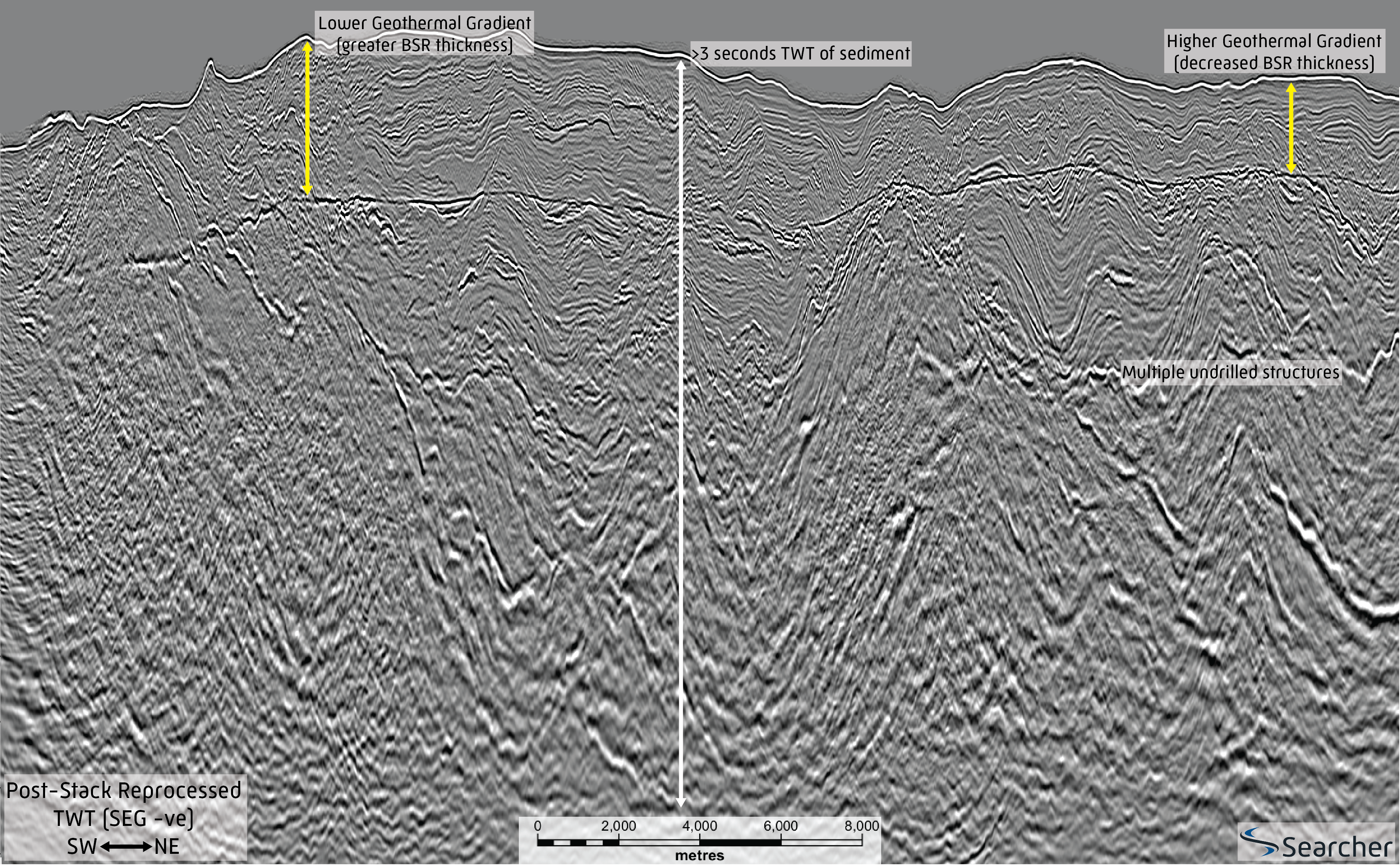
Intriguingly for Ecuador’s prospectivity, a line through TotalEnergies’ acreage shows a clear BSR (Bottom Simulating Reflector; Figure 2) interpreted as the base of an extensive methane hydrate zone which extends all the way from the Trujillo Basin in southern Peru, up to northernmost Ecuador. Using a well-established methodology to back calculate geothermal gradient from methane hydrate thickness, on Figure 2 there is a very clear thinning of the BSR at similar water depths to the north, meaning an increasing geothermal gradient in the Gulf of Guayaquil basin.
Using data from the BSR observed in the Gulf of Guayaquil, a geothermal gradient of up to 30°/ km has been estimated, confounding previous model-based low geothermal gradient estimates, and presenting a real case for thermogenic generation.
Let’s integrate the well data with the seismic data, and re-think reservoir
The well data that Searcher supplies as part of the offshore Ecuador data package demonstrates the presence and quality of sands in the offshore. This forearc setting on the Ecuadorean margin includes quartz-rich coarse clastic sediments pouring off the western margin of the Andes, as the orogenesis of the Andes and its subsequent erosion has generated a continuous supply of coarse clastics flowing east-west, channelled down the Rio Guayas as one of the few places on the margin where a major fluvial system can mature sediments prior to them pouring into the Gulf of Guayaquil rhombochasm from the Mesozoic to the present day.
Thick sands and big structures indicate both excellent prospect and resource density. These structures could be so prolific there are not many underexplored regions of the Earth that have this potential where the hydrocarbon system is already proven.
Let’s re-think about source, heat flow and oil
Thermogenic hydrocarbons are proven at the Amistad Field, the flanks of which have at least 5.5 sec TWT of sediments. Additionally, several old wells reported as dry have been reviewed and found to actually have hydrocarbon shows. Throughout Searcher’s legacy seismic dataset we can also observe numerous fluid flow indicators demonstrating a hydrocarbon system from the deeper parts of the basin showing active thermogenic hydrocarbon generation.
It is as yet unclear what stratigraphic level might be generating the thermogenic hydrocarbon offshore Ecuador. A recently published stratigraphic column by Condor Energy suggests a source may be present in the Oligocene and, indeed, the Eocene as proven in the Tumbes Basin where the Eocene age Talara Formation source rock is proven.
Integrating well and seismic data at a regional scale is key. Some wells offshore Ecuador encountered shale-rich Eocene to Palaeocene intervals which appear to correlate to a regionally extensive high amplitude anomaly on seismic representing a decrease in acoustic impedance. In many places where this potential source rock is buried under thicker sediment (over 5 seconds TWT), we find a strong association to high confidence oil seeps, which can be correlated with fluid escape features on seismic originating at the inferred Eocene to Paleocene source rock level.
Let’s reprocess the seismic and look at this basin with 21st century eyes
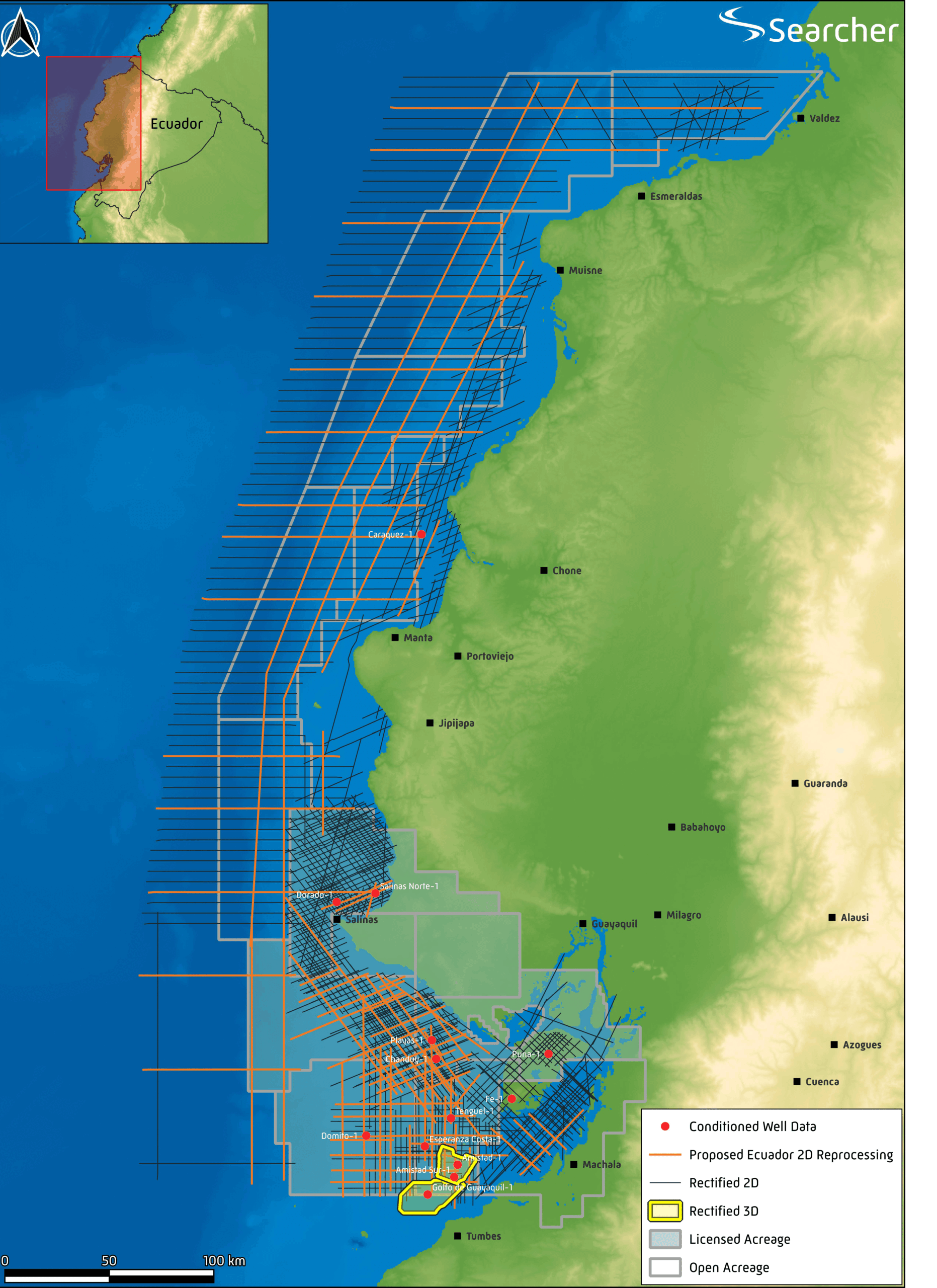
In 2024 Searcher will commence reprocessing of 5,000 km of vintage seismic (Figure 1) aimed at enhancing the seismic imaging and obtaining accurate far angle stacks and flat gathers to address the mapping of regional lower Tertiary sediments.
As a sequel to Californian success, offshore Ecuador has a script rich with classic plot motifs of a Hollywood Blockbuster. A downtrodden and misunderstood geothermal gradient joins a plucky band of thermogenic hydrocarbon indicators; oil seeps, seismic fluid flow and regional source rocks revealed on legacy seismic data. This heroic band take on the stereotypes of received wisdom about the margin and using their super-power; reprocessed seismic, lead the industry to new discoveries where the quartz-rich sediments from the Andes are caught in a massive strike-slip rhombochasm. This unique frontier basin, offshore Ecuador, has a scene set for the sequel to California in the saga of Pacific oil bonanzas.


