Decoding the spatial correlation of pockmark evolution and oil discoveries
Integrating fluid flow indicators, seismic DHI, and source rock modelling to reduce exploration risk
In 1752, at the height of the Age of Reason, Erich Pontoppidan, a Danish theologist, wrote, “It should be assumed that in the ocean as on land there exist here and there, seepages of running oily liquids or streams of petroleum and other bituminous liquids.” Before all modern geology was even a thing, and delightfully conflated with tales of sea monsters and other wonders, the Bishop’s vision rode shotgun for fluid escape being a key observation supporting the presence of a working hydrocarbon system.
Over the last three years, Searcher has acquired over 28,000 km² of new 3D multiclient seismic data offshore the Orange and Pelotas Basins in the South Atlantic, 1,800 km² of 3D seismic data in the Gulf of Papua, and accessed 8,500 km² of Wide Azimuth 3D seismic data offshore Nova Scotia. Studies from these datasets addressing presence and effectiveness of key exploration risk elements; source, reservoir and trap have been much discussed in GEO EXPRO over the last years. All of these basins have seabed pockmarks and strong satellite slick support for the presence of working oil generative systems, but since the 2024/25 Mopane and Capricornus discoveries in the Orange Basin, we can now correlate observations of subsurface flow with oil discovery.
Seabed pockmark trends, indicating points where subsurface fluid flows (oil, gas or water) reach the seabed, are observed on Searcher’s MC 3D datasets in all four basins. With the discoveries of oil on these data in Orange Basin, the spatial correlation of the characteristics of pockmarks, and source maturity modelling suggests these may be hydrocarbon generation and phase indicators.
In the Orange Basin, the larger migrating seabed pockmarks features (Figures 1 and 2, approximately 1,500 m wide and 250 m deep) are densely concentrated over and inboard of the Outer High, a basement ridge trending SE-NW along the basin margin. Oil seepage and slicks are also abundantly observed on SAR satellite images, such as those captured by Clément Blaizot in the same area (Figure 3, RHS). These larger pockmarks, whilst initiated by fluid flow to the surface, are understood to have subsequently migrated down slope under down-dip (gravity-driven) seabed current flow (Figure 3) locally focused through notches / canyons in the shelf edge.
Using exploration well and BSR-derived geothermal gradients to model the maturity of the Aptian source rock over and inboard of the Outer High (Figure 3), the larger pockmarks near the current seabed are spatially well correlated to the modelled, relatively recent generation of oil. On Figure 1, earlier forming large migrating pockmarks are located further to the east. When the early pockmarks formed to the east, the Aptian source rock was buried by an identical thickness of sediment to that above the source rock today in the west. The early pockmarks showed the onset of maturity of the source to the east, which migrated with further burial to the west. Today, the source rock to the east could be generating gas, feeding the narrow “pin prick” fluid pipes seen to the east (Figure 3). Fortunately, late gas is not charging the plays over the inner basin as exploration wells in this fairway are still discovering light oil. In April 2025, Rhino Resources drilled the Capricornus 1-X well, discovering 38 m of Lower Cretaceous sand which produced 37° API oil-on test at rates in excess of 11,000 stb/d.
pockmark clusters are also spatially correlated with numerous stacked AVO Type III anomalies in the underlying Gravity Driven Fold and Thrust Belt (GDFTB). There is possible bimodal correlation of the location of the pockmarks to small faults observed cutting the uniformly bedded mudstones above the GDFTB, however this fluid pathway observation requires further definition.
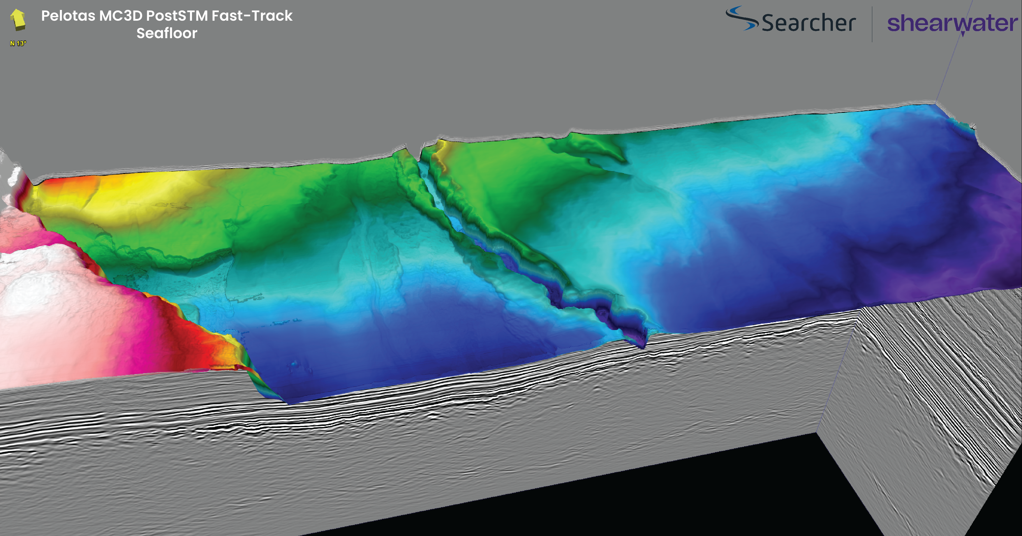
Taking the spatial correlation of modelled oil mature source to pockmark trails across the Atlantic to the Pelotas Basin, it’s cool to observe linear pockmark trails located above the thick (up to 400 m) Aptian source rock that is again modelled to lie in the oil generative window (Figure 4). There are strong AVO and other DHI’s (Direct Hydrocarbon Indicators) throughout the Cretaceous and Early Tertiary plays crossed by the inferred pathway of the hydrocarbon to the seabed, suggesting that the Pelotas is an extraordinarily exciting basin to explore.
A similar relationship has been observed in the Punta del Este Basin to the south, published in GEO EXPRO (Vol. 21, Issue 1, 2024) as part of a joint Searcher Ancap publication. Many authors have noted the correlation of very similar pockmark trails in seabed channels to underlying oil discoveries (for instance, Bryan Cronin recently from the Ghanian Tano Basin, but also examples from Angola, etc).
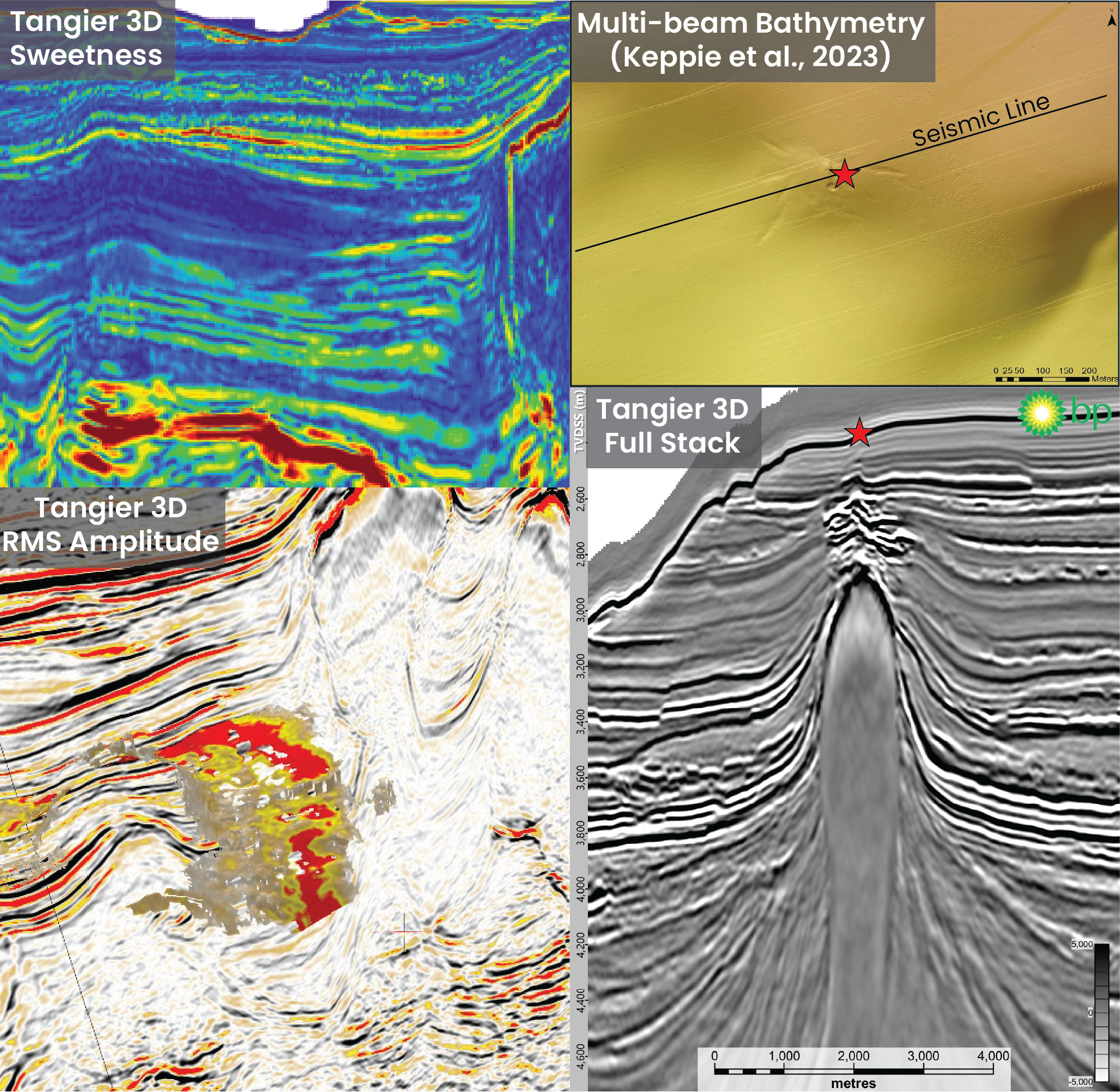
In frontier exploration mode, pockmarks and fluid pathway indicators that correlated with seabed sampled oil can be found in deepwater Nova Scotia, where Searcher offer one of the world’s most rigorously acquired and processed wide Azimuth (WAZ) 3D datasets, the huge Tangier 3D. One recent well drilled in the Tangier 3D area discovered oil in a sub-salt canopy setting. Here we have integrated all the compelling DHI’s and pockmark information revealing a stacked AVO Type III sand channel play (Figure 5), similar to the Yatzil-1 discovery made by ENI in the Campeche salt basin in the Gulf of Mexico. A license round was announced and opened here this month.
Pockmark observations and oil discoveries make a good start to this story. Pockmark evolution, suggestive of early-generated fluid (oil) and late-generated fluid (condensate / gas), provides a spatial correlation that supports a causative model. Getting this story together, i.e. “integration” of fluid flow phenomena with seismic DHI’s and source rock maturation modelling, is a developing toolkit to reduce (or accurately assess) phase risk. Bishop Pontoppidan would approve – and we need to integrate every observation we can make if we expect to get our oil finding game on.


