Admire soaring, fjord-like walls of Mesozoic limestone as you glide through the Strait of Hormuz by dhow, the type of traditional wooden ships that today share this strategic waterway with supertankers and flotillas of Iranian smugglers’ speedboats.
On a visit to Dubai, United Arab Emirates (UAE) we, like the city’s tens of thousands of other daily tourists, were wowed by the towering skyscrapers, glittering shopping malls, and dancing, choreographed fountain and light shows. But we soon yearned to experience the wilder side of Arabia. Fortunately, this exists a mere 2.5-hour drive north-east, on Oman’s Musandam Peninsula.
The walls of Khor Ash Sham, which rise 800m directly from the water, consist of Triassic Elphinstone Group overlain by more resistant Musandam Group limestone. © Lon Abbott and Terri Cook.
The Musandam Peninsula, the northernmost point of Oman, separates the Indian Ocean from the Arabian Gulf.
This isolated finger of land, which is little more than 20 km wide at its southern base, separates the Gulf of Oman to the east from the Persian (or Arabian) Gulf to the west. Every day 22.5 MMbo – 24% of the world’s global daily production, according to Vortexa energy analytics – pass through the adjacent Strait of Hormuz, the narrow waterway between these gulfs, making it one of the most strategic spots on Earth. In addition to being a geopolitical nexus, the Musandam marks the boundary between the modern Makran subduction zone on the east and the Zagros continental collision zone to the west, making it a geodynamic nexus that has received considerable attention from tectonicists.
From Dubai Glitz to Wild Arabia
As we barrelled north-east along a motorway from Dubai paralleling the UAE’s flat coast, the first hint of wilderness came after we passed through the city of Ras Al Khaimah, capital of the north-easternmost of the seven emirates that comprise the UAE. The city’s suburbs sprawl eastward to the foot of the Musandam mountains, which rise 1,600m above the coastal plain.
The Musandam mountains are the northernmost extension of the Hajar range, which hugs the Arabian Peninsula’s south-eastern coast from the Musandam to south of Muscat, Oman’s capital. The Hajar was raised by thrust faulting that began in the Oligocene and ended by the middle Miocene; the Hagab Thrust, which lies at the foot of the Musandam range, has accommodated about 15 km of east–west shortening, making it the master fault in this region.
We crossed the Hagab Thrust at the UAE–Oman border. Rugged, desert mountains rose directly from the water as we wound our way around one inlet after another on the remainder of the scenic drive to Khasab, the Musandam’s main town. Khasab lies just 20 km south of the Strait of Hormuz.
Cruising Through the Norway of Arabia
The Musandam’s tourist tagline touts it as ‘the Norway of Arabia’. The validity of that comparison becomes evident on a day-long dhow cruise through Khor Ash Sham, the largest of the many ‘fjords’ that grace the region. Because no glaciers have covered the Arabian Peninsula since the Permian, these aren’t actually glacial valleys. Rather, they are rias, drowned river valleys that strongly resemble fjords. The Musandam’s rias, which are among the most impressive on Earth, have formed because the Arabian continental lithosphere is being flexed down to the north, causing subsidence at a rate of about 6 mm/yr as the Eurasian plate overrides the Arabian plate.
Sunset in Khor Ash Sham, the longest ‘fjord’ in the Musandam peninsula. © Lon Abbott and Terri Cook.
The north-eastern Arabian Peninsula became a rifted margin in the Permian during the opening of the Neotethys Ocean. The area remained a stable continental platform from the Permian through the Early Cretaceous, accumulating a 4 km-thick section dominated by platform carbonates that host some of the world’s biggest oil fields. The platform’s tectonic serenity was disrupted during the Late Cretaceous, when the famous Samail Ophiolite and the associated deep-marine sedimentary rocks of the Hawasina Complex were thrust south-westward over the Arabian passive margin. Vast expanses of the Hajar mountains consist exclusively of that ophiolite, the world’s biggest and best-preserved such exposure, although it crops out only at the extreme southern reaches of the Musandam, in what is known as the Dibba Zone. The rest of the peninsula displays spectacular exposures of the most continuous section of Mesozoic sedimentary rocks on the Arabian Peninsula, making the Musandam a playground for field geologists seeking close examination of the reservoir rocks that host the region’s giant oil fields.
The dhow cruise of Khor Ash Sham. © Lon Abbott and Terri Cook.
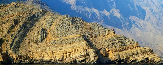
We got to examine this sequence on a dhow cruise of the 16 km-long Khor Ash Sham, the longest of Musandam’s rias. Cretaceous platform carbonates belonging to the Thamama and Wasia Groups comprise the mountains encircling Khasab and surround the mouth of Khor Ash Sham, which lies just a few kilometres to the north-east. As our dhow chugged deeper into this ‘fjord’, the peaks rose higher and higher, the tallest soaring 800m above the water. Several major east-dipping thrust faults cut the tightly folded sedimentary layers, so the farther east we ventured into the ria, the older the rocks became.These faults all piggyback atop the Hagab Thrust; together, their Oligocene through Early Miocene motion built the Musandam mountains.
First we passed from the Cretaceous carbonates to an overlying thrust sheet composed of the 1,500m-thick Jurassic Musandam Group carbonates. The ria widens to about 3.5 km where it crosses onto the next, structurally higher, thrust sheet. That widening is likely due to the exposure at sea level of more easily eroded orange, ferruginous sandstones interbedded with oolitic limestones that belong to the Upper Triassic Ghalilah Formation of the Elphinstone Group (Khor Ash Sham used to be called Elphinstone Inlet). Cliffs of Musandam Group limestone tower above the less-resistant Elphinstone rocks.
Folded Elphinstone Group rocks, with Musandam Group Limestones forming the mountains behind. © Lon Abbott and Terri Cook.
Dolphins played in the dhow’s bow wave as we headed to Telegraph Island, the most famous of several small islands located in this comparatively wide portion of Khor Ash Sham. We anchored just offshore for the first of two sessions of snorkelling and swimming in the clear water. Telegraph Island was the site of a repeater station, the ruins of which remain visible, on the London-to-Karachi telegraph line built by the British in 1864.
The line was abandoned less than 10 years later, but while it operated Telegraph Island was infamous as a hardship post. The summer heat is fierce and, although the British maintained extremely close relations with the Sultanate of Oman, some of the local tribes were sufficiently hostile that a gunboat had to be available at all times. The Oxford English Dictionary asserts that the idiom ‘go round the bend’ is an old naval term for someone who goes mad. Some claim it derives from the long procession of British naval officers who were slowly driven mad by the hardships and isolation of Telegraph Island and were recalled to India, rounding the bend in the Strait of Hormuz as they left.
Telegraph Island was the site of a repeater station, the ruins of which remain visible, on the London-to-Karachi telegraph line built by the British in 1864. © Lon Abbott and Terri Cook.
The Strait of Hormuz
Being so close to the Strait of Hormuz, there was no way we could pass up a chance to explore it. Although such trips are not on the standard tourist itinerary, we had no trouble hiring a dhow to make the full-day journey around the Musandam’s northern tip from Khasab to the village of Kumzar, Oman’s northernmost settlement. Throughout the voyage we were treated to spectacular scenery, with the craggy coastline and rugged mountains all comprised of Jurassic and Cretaceous shelf limestones. As we neared the Strait, we glimpsed several supertankers and cargo ships through the marine haze.
Islets in the Straight of Hormuz. © Lon Abbott and Terri Cook.
We then passed west of Jazirat Al Ghanem Island, home to an Omani naval base perfectly positioned to monitor the strait’s voluminous ship traffic. As we neared the island, we suddenly heard a cacophonous, high-pitched whine that turned out to be the vanguard of a flotilla of dozens of speedboats outfitted with multiple, oversized motors racing in formation southward toward Khasab. We reached for our cameras to record this unusual site, but the speedboats were so fast they were mere specks in the distance by the time we had our lenses trained on them. Our dhow pilot smiled and told us they were Iranian smugglers, who regularly come to Khasab to buy cigarettes and alcohol before returning to Iran at night. His prophecy was correct: that evening, as we sailed back to Khasab, the flotilla, whose pilots all stood at the tiller carefully surveying the scene around them, raced passed us again. What an unusual, exhilarating, and dangerous career that must be!
A Glimpse of Old Oman
As our dhow rounded the northernmost tip of the Musandam Peninsula we eagerly scanned the horizon for our first glimpse of Iran, expecting to spy Qishn Island, the southernmost anticline in the Zagros fold and thrust belt and the closest Iranian land, 56 km north-west of Kumzar. But the island never emerged from the marine haze. Instead, we looked south-east, across the Gulf of Oman, to glimpse mainland Iran. There, a mountain range with peaks up to 1,900m has been built by transpression along the north-west-trending Zendan fault, the structure that transfers plate boundary slip from the northward subduction of Arabian oceanic lithosphere beneath the Makran region of eastern Iran to the Zagros continent–continent collision zone. The imbrication of underthrust Arabian continental lithosphere has raised the Zagros Mountains, complete with their famous salt diapirs sourced from Neoproterozoic Hormuz salt deposits, which are so voluminous that they produce salt glaciers.
The authors stroll through isolated Kumzar. © Lon Abbott and Terri Cook.
When we reached Kumzar, we got a glimpse of how dramatic Oman’s recent modernisation has been. Khasab, with its modern port facilities and plenty of new buildings, embodies this modernisation. Kumzar, by contrast, was a glimpse of the old Oman, with goats roaming its rough gravel streets and threadbare couches perched on makeshift balconies from which residents survey the scene during warm Musandam evenings.
Sultan Qaboos bin Said al Said ruled Oman from 1970, when he staged a coup d’état against his father, until his recent death on 10 January 2020. When he ascended to the throne, Oman was poor and isolated, but he used the country’s growing oil revenues to fund an ambitious modernisation programme that has resulted, among other things, in gleaming buildings, airports, and a road network ranked among the world’s best. The pace of change is so rapid it is reaching even this most remote Omani outpost; we found crews hard at work building a road that climbs up and over the rugged Musandam mountains to link the very different worlds of Khasab and Kumzar.
Birth of a Nexus
While geographers and historians have pondered the geographic significance of the Strait of Hormuz, geologists have worked to explain how this narrow pinchpoint formed. Studies have shown that prior to 5 million years ago, the Makran and Zagros fold and thrust belts both involved thin-skinned deformation and were part of the same subduction zone. A sharp, north-trending geophysical boundary that coincides with the Musandam mountains and extends northward to Bandar Abbas, Iran, is thought to be a relict transform fault formed during the opening of the Neotethys.
Fjord-like walls of Khor Ash Sham rise 800m above sea level. © Lon Abbott and Terri Cook.
Arabian continental lithosphere is offset to the north along that transform fault from the Musandam westward. That offset destined the continental lithosphere west of the Musandam to enter the trench first, which it did about 5 million years ago, initiating continent–continent collision and slowing the convergence rate there, which today is 9±2 mm/yr. Oceanic subduction continued east of the Musandam, as it does today at a rate of 19±2 mm/yr. This difference in convergence rate produced the northward step in the Iranian coast that forms the Strait of Hormuz and gave birth to the transpressional Zendan Fault.
Perched on the edge of one of the world’s most important seaways, the Musandam offers glimpses into several very different worlds. We witnessed not only a subduction zone transitioning to a collision zone and the commercial realities of modern-day Iran, but also an Oman from a different time, one that will not last much longer. Lastly, we saw for ourselves the incessant ship traffic that makes the region so commercially important and glimpsed the unique geography that makes the Strait of Hormuz a location of almost unparalleled strategic importance.
Further Reading
The Best Geological Site in the Middle East
Jane Whaley
Join us as we take a look at just one of Oman’s many geological wonders: Wadi Nakhr, in the Al Hajar Mountains.
This article appeared in Vol. 15, No. 1 – 2018
The Search for Oil in Oman
Michael Quentin Morton
A discovery at Yibal in April 1962 marked the end of a long and frustrating search for commerical oil in the Sultanate of Oman. The country is now 24th in the global oil production table with reserves of about 5.5 Bbo.
This article appeared in Vol. 9, No. 1 – 2012


