Chevron has big ambitions in the North Atlantic Volcanic Margin. They believe the region can hold significant resource and be a major growth area for the Company for years to come. To succeed it takes courage, knowledge and experience, and – of course –financial capability.
“Our North Atlantic Margin Exploration team is focused on opportunities that may turn out to have substantial reserves,” says Team lead Dag Helland-Hansen, in Chevron Norway. “In addition, we focus our efforts on areas with seismic imaging problems, being sub-salt or sub-basalt, because these areas tend to be under-explored and hence the potential is greater.”
The latter doesn’t sound like a winner, because there is no known correlation between seismic quality and field-size. An explanation is thus required, and that is found in the prolific deep water Gulf of Mexico where Chevron has its fair share in several large discoveries, including Tahiti, Great White, Jack, Knotty Head, Mad Dog and St. Malo and now lately Buckskin.
“We are building on the success that Chevron has had in sub-salt plays in the Gulf of Mexico. By transferring knowledge gained and technology developed in this province, we believe that we have a competitive edge in the deep water geological provinces of Northwest Europe,” Dag says. This strategy has proven successful in UK waters as demonstrated by the significant Rosebank oil discovery made in 2004.
Deep water Gulf of Mexico exploration is characterised by several types of technical challenges with respect to both seismic imaging and drilling. In particular, geologists and geophysicists are struggling with sub-salt and pre-saltimaging, in which the salt may be several thousand meters thick.
Finding a look-alike
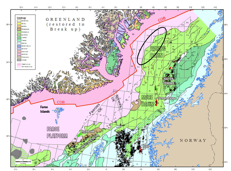
In November last year, Chevron Norge took part in the 20th licensing round offshore Norway. Blocks were announced both in the Norwegian Sea and in the Barents Sea, in shallow and deep water, and in areas with poor and excellent seismic quality. In the Norwegian Sea, Chevron chose to build on their experience from the volcanic margin further south in the Faroe-Shetland Basin.
“In this way we are taking advantage of our expertise, going from sub-salt in the Gulf of Mexico, to sub-basalt west of Shetland to sub-basalt west of Norway,” Kine Årdal says, geologist with Chevron for more than six years, proud of the company’s willingness to challenge the extreme.
“We see this as a way of creating competitive advantage for us and strengthening our ability to bid for and win high potential acreage. Also, such areas have in general seen little exploration and may still hide big secrets in strata with poor seismic signature,” Kine adds.
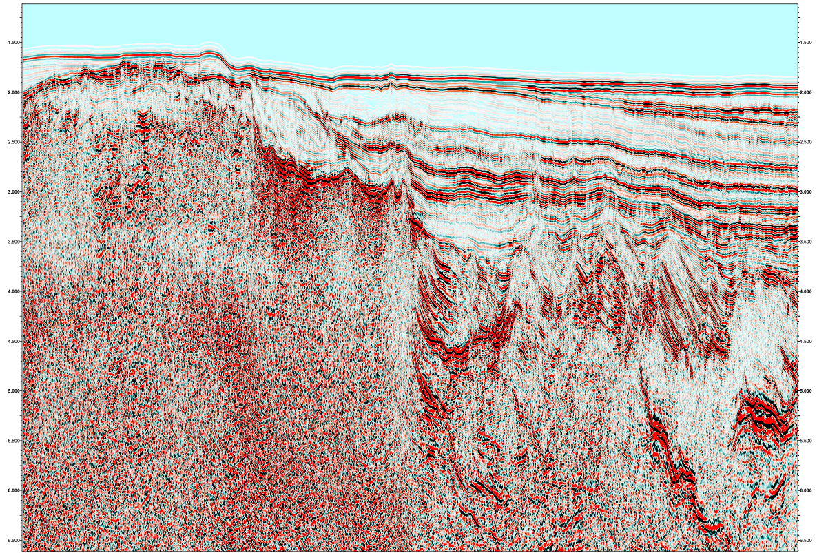
It all started with a seismic line displayed in a previous issue of GEO ExPro (No. 2, 2007, pp. 36-38). It is a “foldout” (3 pages) illustrating a transaction of the Mid-Norway continental shelf from the Trøndelag Platform in the east and all the way to the volcanic margin and the Vøring Marginal High in the west. The western part of the line (compare illustration) clearly demonstrates that the seismic character changes when passing the Gjallar Ridge, thereby reflecting the volcanic character of the margin.
“When I first saw this line in the magazine, I immediately recognised a seismic pattern that reminded me of the newly discovered Rosebank in the Faroe-Shetland Basin,” says Dag. Dag has worked in the oil industry for almost 15 years after graduating from the Norwegian University of Science and Technology. In 2003 he joined Chevron; three of those years that have passed he spent in Aberdeen, taking part in appraising and evaluating the Rosebank discovery, thereby getting intimate knowledge of both the field and the seismic signature.
The next step was to acquire the data and take a closer look. So, let’s have a quick look at this exciting field with reservoir in between volcanic.
Reservoir between volcanic rocks
Almost five years ago, Chevron made a significant and highly interesting oil and gas discovery some 150 km northwest of Shetland and adjacent to the UK/Faroe Islands median line. Well 213/27-1Z was drilled in 1100 m of water on an anticlinal closure on the northeast-southwest trending Corona Ridge. The well encountered two oil and gas accumulations for a total net pay of 52 meters with oil quality ranging from 27-36 degrees API.
Blocks 213/26 and 213/27 were awarded to Chevron subsidiary, Texaco North Sea U.K. Company (100%), under the UK 19th Licensing Round in 2001. DONG Energy, OMV and StatoilHydro farmed into the license before the first exploration well was drilled. Chevron and partners subsequently strengthened their position in the UK 23rd licensing round in 2005 securing additional acreage in proximity to the discovery.
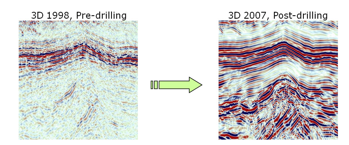
Since 2004, three appraisal wells have been drilled. The second, 205/1-1, was completed in 2007 and flowed at choked rates of 6,000 bopd of good quality light oil (37° API). Chevron and its partners invested more than 300 million dollars in this appraisal programme which started in October 2006.
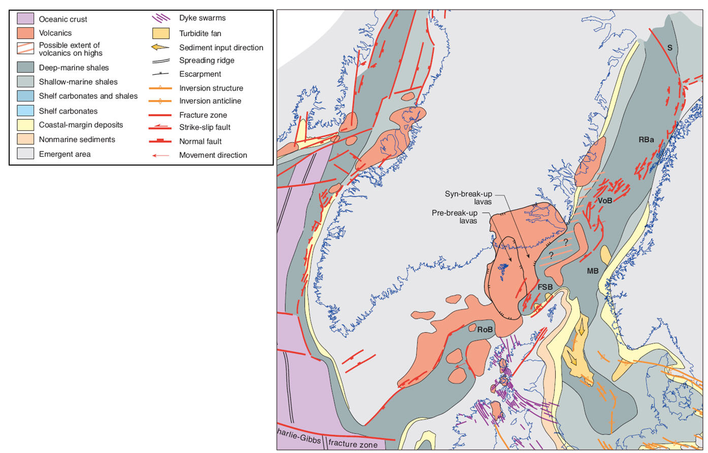
Hydrocarbons have been encountered in several reservoir zones within Eocene sandstones that lie in between thick layers of basalts and volcanics. As such, Rosebank is so far unique to the Northwest European shelf, no other field, at the time of discovery, has oil reservoired in between volcanic rocks. The geological maps on these pages illustrates that Rosebank is situated within the volcanic province that has resulted from the volcanism associated with the breakup of the North Atlantic Ocean in the Eocene (55Ma).
The Rosebank reservoir sandstones are interpreted to consist of distal equivalents of the Eocene north-westwardsprograding Flett delta. Synchronous to the build-up of the Flett delta was a long term volcanic eruption associated with the break-up of the Atlantic Ocean. The basaltic lava flows, hyaloclastites (lava flowing into water and water-saturated sediments) and associated erosion products generated an eastwards prograding system which filled up the basin to the west of Rosebank.
“Rosebank has proven crestal hydrocarbons in several separate zones on a large structure. However we recognize significant challenges caused by the volcanic-siliciclastic inter-fingering. Going forward, we address the challenges with the new well/production data in a cross-disciplinary sub-surface characterization, aided by carefully reprocessed seismic and undertaking field work on intra-basalt plays,” says Dag.
Reducing risk
At Chevron they are now waiting eagerly to learn the outcome of the 20th licensing round due to be announced in April. If the company is awarded the acreage, a dedicated high-tech seismic programme will follow for the purpose of improving the geologic knowledge in the area, evaluate the prospectivity and find the best location to drill a well to test the play.
“We need more data, but first and foremost we need to improve the data imaging in these sub-basaltic plays in order to reduce the risk, which should certainly not be ignored in this case,” Dag emphasises, “and we will of course rely heavily on our colleagues in Aberdeen, Houston and San Ramon, California with whom we have been working closely for a long time.”
“Given that new and improved data confirms the original interpretation, we are talking about a potential huge prospect. Gas is the most likely case,” Kine says, who also realises that the risk is high. “But that was also true for the Gulf of Mexico Wilcox trend.”
High risk, high reward; Chevron wants to find the BIG ones.