The importance of depth imaging
Depth modelling using several algorithms has significantly improved salt imaging in the deepwater Bay of Campeche.
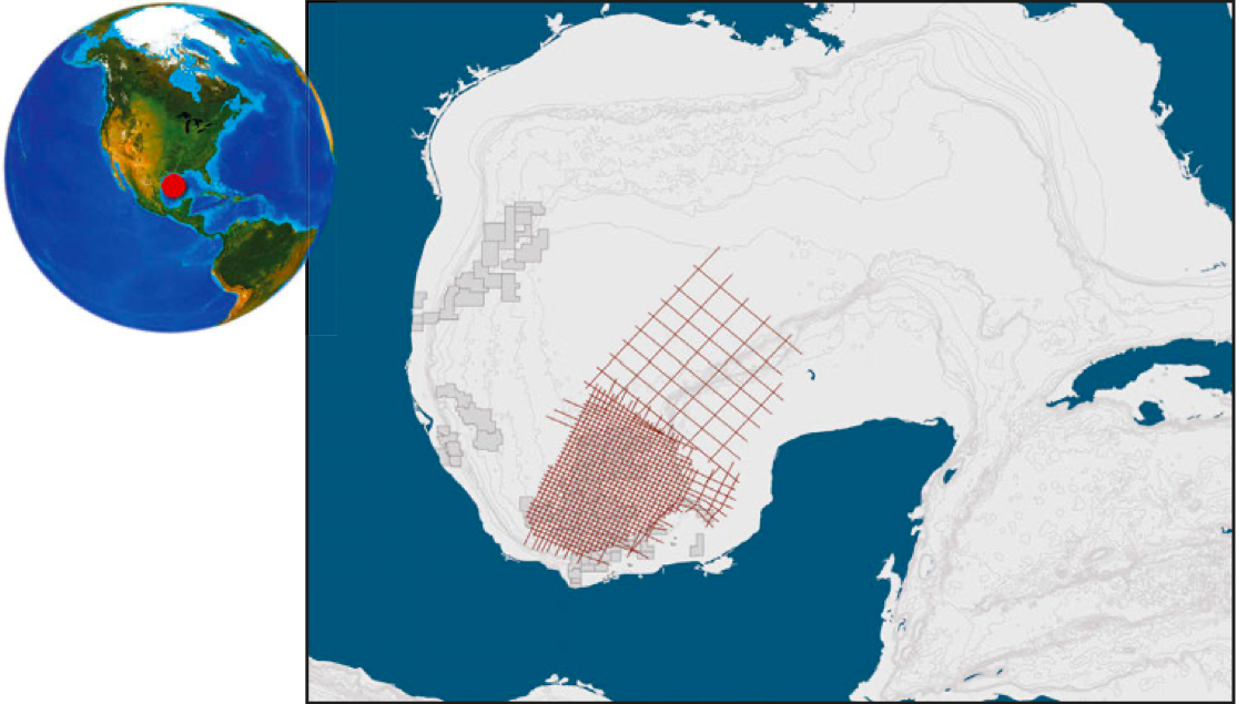
The Bay of Campeche lies along the western border of the Yucatan Peninsula. The shelf contains a system of horst and grabens that are affected by salt intrusions, creating very complex structures, which involve severe folding, faulting and fracturing due to salt movement, mobilised by sediment loading. Mobilisation of the salt was initiated around the Late Cretaceous, possibly by a combination of the sediment overburden and Laramide-style compressive stresses from the southwest. Salt uplift continued during Palaeocene, Eocene and Oligocene depositional sequences in the coastal plain and persisted until the Miocene. Within the Bay of Campeche many structures are influenced by thick allochthonous middle Jurassic salts, while in the Yucatan Peninsula, salt bodies are thinner and considered to be more autochthonous. Primary exploration targets within the Bay of Campeche include conventional pre- and post-salt depositional structural and stratigraphic traps, both in the shelf margin and in deep waters.
Since 2013, when Mexico changed its policy allowing foreign exploration companies to invest and explore for oil and gas onshore and offshore Mexico, there has been an increased interest in the hydrocarbon potential of the southern Gulf of Mexico. MultiClient Geophysical (MCG) acquired the Maximus survey in 2015–16 over the Bay of Campeche and the Yucatan Platform. The Maximus survey is a high-resolution 2D seismic survey ith very long offsets (12 km) and deep recording (14 seconds) with the objective of providing a clear image of all the play elements of the petroleum systems offshore Mexico. The processing sequence used state-of-the-art broadband solutions. High quality pre-stack time, pre-stack depth, gravity and magnetic data are available, and this survey is in a position to support future licence bid rounds offshore Mexico.
3D Velocity model
Imaging complex structures, such as fold belts and salt-related structures, is challenging. These challenges were addressed though new pre-stack depth migration sequences. However, the success of seismic imaging methods not only depends on data quality, but also on accuracy of the background velocity model. When lateral velocity variations are significant, the generation of an accurate velocity model using a standard velocity analysis is difficult. For this project, a thorough interpretation of salt bodies and a local velocity model was created in order to support high quality imaging techniques.
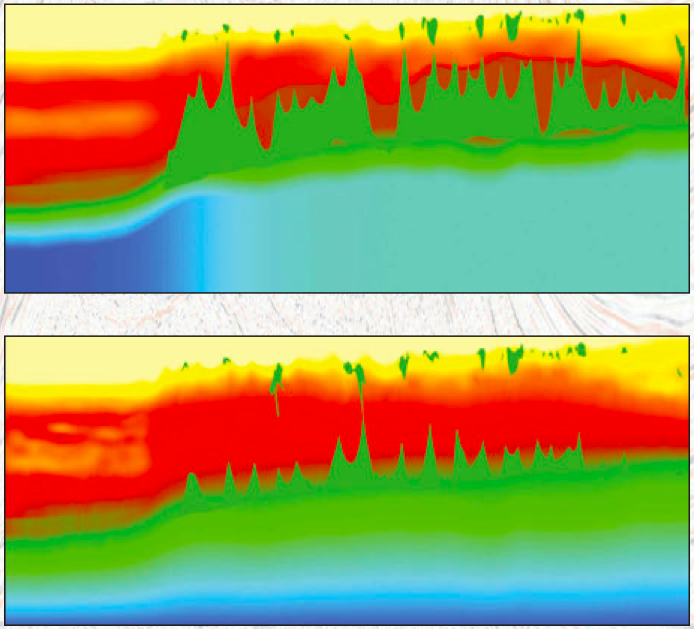
The original processing was done by iterations of sediment model-building, picking top salt, flooding with salt velocities, picking bottom salt and revising the salt picks where needed. These 2D velocities were used to build a pseudo 3D velocity model which avoided depth-velocity mis-ties at line intersections. The initial model was generated using time RMS velocity models, followed by at least three iterations of sediment velocity tomography and inclusion of salt geometries for each line, which were then incorporated into the final 3D model. The resulting imaging from Kirchhoff Pre-Stack Depth Migration (KPSDM) was of good quality, especially in the sediment package. However, it did leave some room for improvement in more complex areas, where a refined salt interpretation may lead to enhanced imaging, especially with more advanced migration algorithms. In such complex areas, more work needs to be done to help define the salt geometries.
The process of enhancing the product was aided significantly by involving interpreters with extensive local experience. Changes to the shallow salt involved re-picking the base of many of the salt geometries and removing significant salt stalks. The deeper salt was modified to remove significant volumes of salt, which relied on the interpreters’ experience and knowledge of the expression of the salt and its movements in the local geological setting. The salt modelling followed standard methods of picking a top salt on a Kirchhoff stack image, but several migration algorithms were used to test base salt scenarios after ‘salt-flooding’ the model.
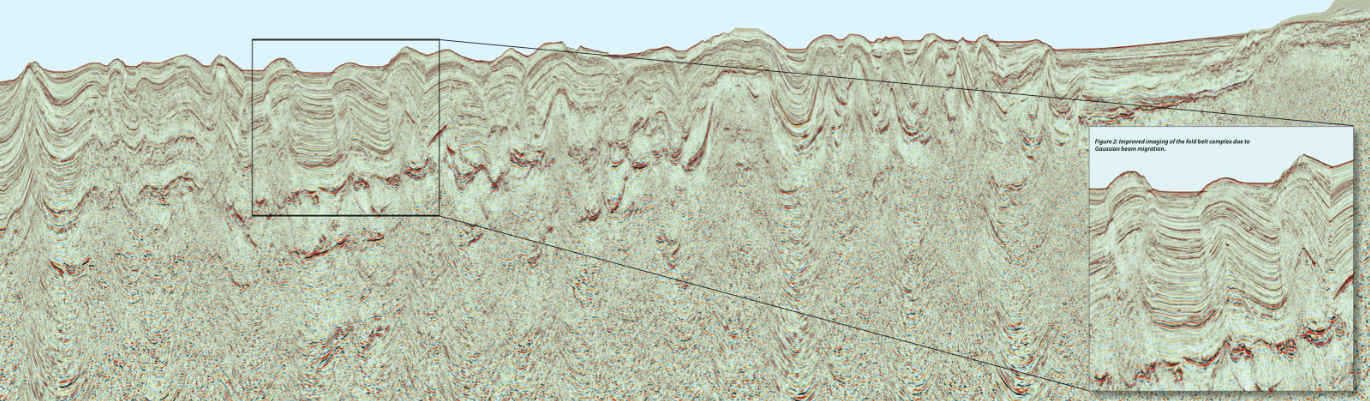
During this and further model building KPSDM was the main tool for assessing the sediment modelling. Gaussian Beam Migration (GBM) was effective in areas with complex ray-paths such as those found near salt flanks and areas with overhanging salt and salt feeders or stalks. Lastly, Reverse Time Migration (RTM) was used, mainly to evaluate the model below the allochthonous salt and for the modelling of the autochthonous salt. The interpreters used all migrations to adjust the salt interpretation. The process was iterated at least five times until no further improvement was seen. Some regional complexity was added to the model, including a new transition from the base of the autochthonous salt to the base of the model (Figure 4).
Care was taken to adjust for some unreasonably high velocities at or near tips of salt structures that were suggested by the tomography.
The final, individual 2D velocity models of the selected lines are structurally consistent and highly resolved, tying at the intersections and producing better pre-stack migrated images.
Enhanced imaging
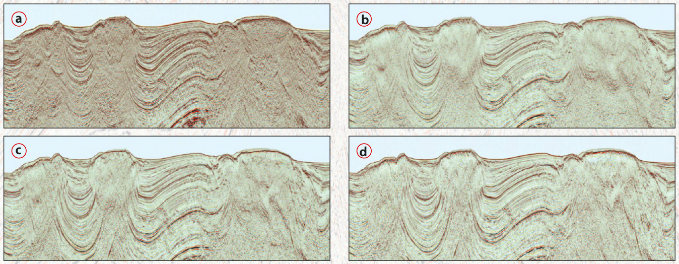
The final images were built from each of the three different algorithms, KPSDM, GBM and RTM. Careful consideration and testing of key parameters for each migration was undertaken. At this phase of the project there were no surprises in parameterising each of these migrations, as they had all been used and the parameters optimised along the way. Key parameters such as aperture, aperture taper and antialias filters had been tested and optimised. For each of the migrations the maximum aperture was set to 12,000m radius.
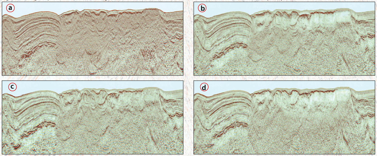
GBM has the advantage of being better at imaging steep dips such as seen at salt flanks and salt stalks (Figure 5). The 45 Hz mid-frequency RTM final product gave the best pre-salt images (Figure 6).
All these modifications to the original models and inclusion of additional migration algorithms resulted in significant improvements in the sediment and deeper pre-salt imaging within the Bay of Campeche and Yucatan Peninsula. With this improved new dataset, exploration companies will be able to generate new exploration prospects in preparation for future bid rounds.
Further reading
Caribbean Atlantic Margin Deep Seismic Imaging
Jennifer Masy, Tom Wolden and Robert Sorley; MultiClient Geophysical AS (MCG)
A new regional study of the South-Eastern Caribbean hydrocarbon exploration opportunities using deep seismic imaging.
This article appeared in Vol. 16, No. 6 – 2019
New Seismic Data from Morocco Reveals Fascinating Geological Insights
Steve Lawrence; SRC for Geoex Ltd
High-resolution 2D seismic data acquired by Geoex provides new clues to crustal architecture and deformation history in Atlantic Offshore Morocco.
This article appeared in Vol. 16, No. 3 – 2019
New Hydrocarbon Prospects in Equatorial Guinea
Chris Irons and Richard Bray, SAER Ltd; Peter Abrahamson, Geoex Ltd.
New 3D surveys, covering over 8,400 km2, have identified a large number of new hydrocarbon prospects in Equatorial Guinea.


