Frontier exploration
Despite previous disappointments, geologists can now demonstrate the probable presence of prolific source rocks, good reservoir rocks and huge structures in an area that is now open for licensing.
Poor seismic coverage, in combination with outdated geological models, has so far largely kept the oil industry away from the West-Greenland offshore sedimentary basins. There is also a scarcity of borehole data, as only six wells have been drilled so far. Several wells have, however, been drilled in shallow waters of the Labrador Shelf, proving a working hydrocarbon system further south and west, although most of the finds predominantly contain gas.
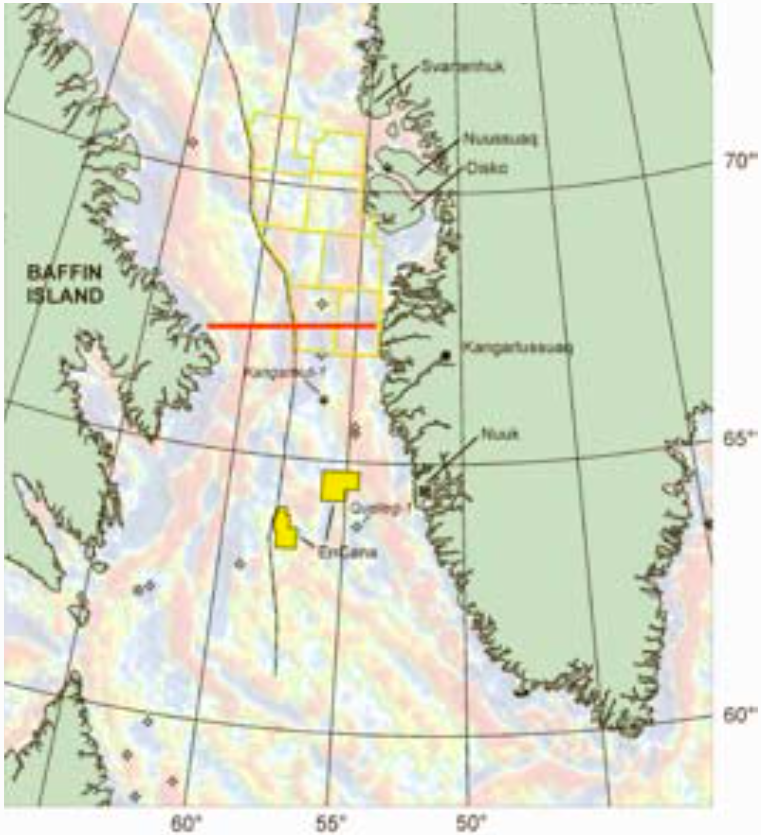
The acquisition of modern seismic data, gravity profiles and aeromagnetic surveys has during the last six years gradually changed the oil industry’s view of the prospectivity west of Greenland. The authorities in Greenland (Bureau of Minerals and Petroleum; www.bmp. gl) has thus experienced an increased interest in the oil potential offshore West-Greenland. In the upcoming licensing round offshore the Disko-Nuussuaq region, 12 international oil companies have been pre-qualified as operator. The criteria for qualifying as an operator are chosen to protect the fisheries activities in the area, and the unique populations of whales, walruses and bird colonies.
Exploration history
Hydrocarbon exploration offshore West Greenland was initiated in the beginning of the 1970’s. Five exploration wells resulted. None had oil shows, but one of the wells detected gas under high pressure (Kangamiut-1). A production test only yielded drilling fluids.
Oil seeps were first registered on the Disko Island in 1992 due east of the area that is now offered for licensing. In the following years numerous seeps were recorded over a wide area, extending from northern Disko through Nuussuaq peninsula to the southern part of Svartenhuk peninsula further to the north. In 1996, additional oil shows were reported from a 3000m deep exploration well drilled on Nuussuaq by the Canadian company Grøn-Arctic Energy Inc. Oil proved to be present throughout the whole volcanic rock sequence.
In the period 1999–2003, commercial geophysical companies acquired extensive new non-exclusive seismic data offshore West Greenland, and in 2000, a group led by Statoil drilled Qulleq-1. The well was dry but showed the existence of good quality Upper Cretaceous sandstone reservoir rocks.
The only existing exploration licenses offshore Greenland, awarded in 2002 and 2005, is operated by the Canadian company EnCana (compare map). No wells have been drilled on these licenses yet.
The petroleum system
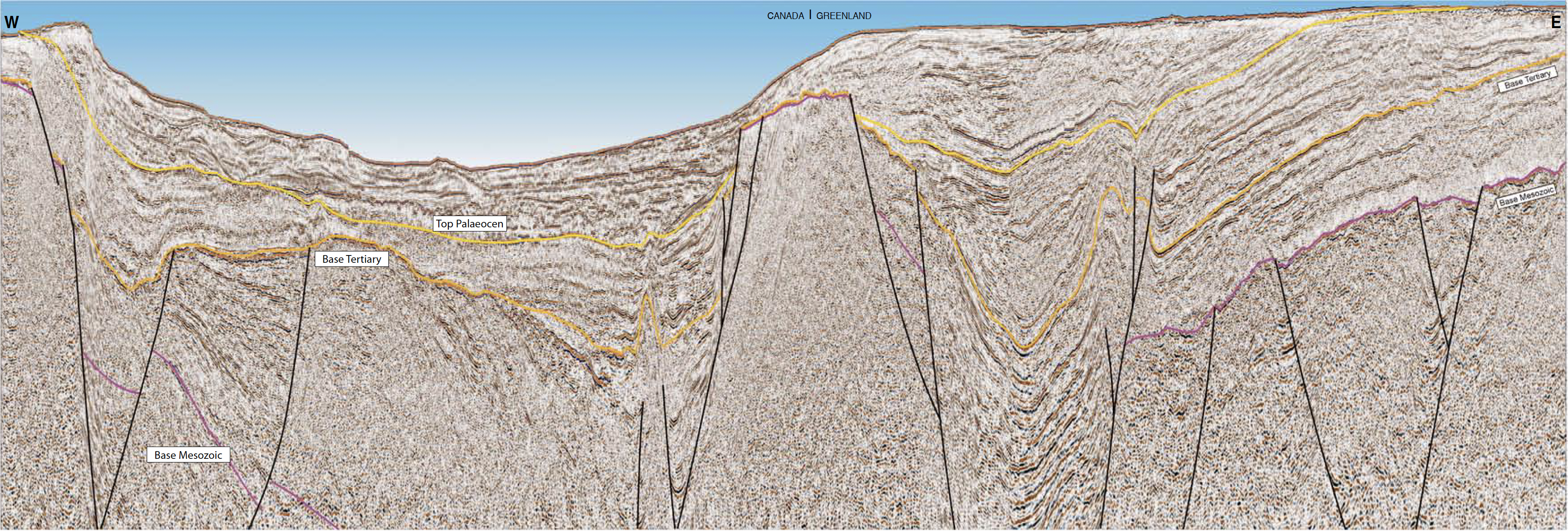
The seismic data acquired over the last 5-10 years have revealed the existence of very large sedimentary basins offshore West-Greenland. An integrated evaluation of seismic, gravity, magnetic and satellite data – primarily collected trough the last 5 years – confirms the possible existence of a very large interconnected Mesozoic grabens with petroleum deposits along the so-called Ungava Fault Zone with the Central Ungava Horst consisting of Pre-cambrian granites. This basin system links the petroleum deposits in the Labrador-sea south of 60 °N, with the collected oil seeps on Disko- Nuussuaq, all the way up to 71 °N.
Numerous and widespread oil seeps next to the license round area, in combination with amplitude anomalies and shallow gas related features observed in the seismic data, clearly indicate the presence of source rocks. There are so far documented 7 different distinct types of oils ranging in age from Paleocene through the Cretaceous, Jurassic and all the way down to the Paleozoic, thus giving the possibility of several different play concepts.
Reservoir rocks do also exist in several stratigraphic intervals. There are many good analogues onshore, and throughout Cretaceous and Paleocene huge quantities of sand were poured into the basins. The seismic data indicate the possible presence of Jurassic rocks in the offshore basins, even if they have not yet been found onshore or offshore.


