
What lies offshore Florida?
Despite recent political events cooling interest in the area, newly acquired seismic shows that there remains considerable potential in the easternmost part of the Gulf of Mexico.
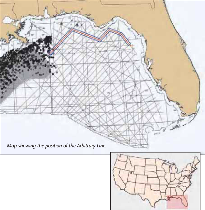
In the Federal Waters offshore the West Coast of Florida and Alabama there has been a renewed interest in exploration, although recent political events had cooled interest in this region for a while. New regional long offset seismic data acquired by Fugro in 2009 and 2010 suggests that the Eastern Gulf of Mexico (EGOM) shelf and slope show potential for new oil and gas plays. Integration of this seismic with newly acquired gravity, magnetic and biostratigraphic data, together with well log information, is providing insight into the evolution of the Gulf of Mexico basin.
The new seismic data extends from the Florida coast westward to the central Gulf, tying previous surveys acquired by Fugro with three lines extending to the Texas shelf. The Deep East Survey is made up of over 35,000 km of 10 km offset seismic data along with gravity and magnetic data acquired across the shelf in various orientations, providing a comprehensive look at the deep structure. The Survey ties most of the exploration wells on the Florida shelf and incorporates the geological interpretation from those drilled on the slope.
Eastern GOM geology revealed
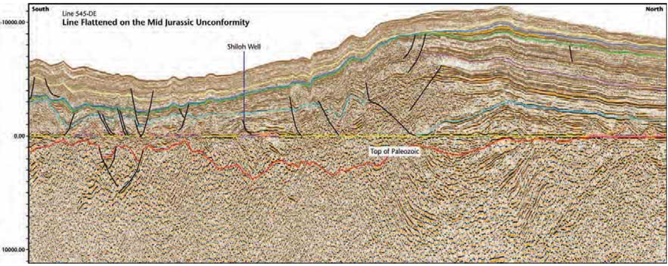
Geological data from the EGOM indicates rocks range in age from Paleozoic to Recent. New regional seismic data suggests that folded Paleozoic age rocks extend under the Florida Shelf. The folds have been extensively modified by subsequent rifting in the Triassic and early Jurassic. The grabens created by this rifting are filled with clastic and evaporite sediments, which are distributed extensively across the shelf but are relatively thin. Deeper sediments that had been interpreted as Triassic basin fill on older data now appear to be folded Paleozoic rocks. Thick Paleozoic strata are also found in the southern part of the Eastern Gulf of Mexico along the border with Cuba where continental – transitional to oceanic crustal boundaries are not always clearly defined. Seismic data across the margin suggests there are early stages of rift that failed or translated to the Atlantic Margin at some point before or during the Permo-Triassic.
Jurassic Cotton Valley Group, Smackover, Norphlet Formations and the Louann Salt extend southward from the Florida panhandle onto the Florida shelf and slope. However, the area is at the Eastern Margin of the Gulf of Mexico Salt Basin, where less salt formed than in the central Gulf of Mexico. Salt was also deposited on the paleo-shelf in the Destin Salt Basin. The thickest parts of the salt basin are located around the base of the modern Florida Escarpment where paleo salt rafts were able to form.
New plays and ideas
The Eastern Gulf of Mexico will be explored as an extension of current plays being made both onshore and offshore Louisiana and Alabama. Interpretation and integration of new data will help to develop new ideas for the region. One of the more recent plays in the EGOM is the Southern and Eastern extension of the Jurassic Norphlet Formation. Interest in this play increased with the results from the Shiloh Well, drilled in Desoto Canyon 269 by Shell and partners in 2003. This well, drilled to approximately 7,300m (24,000 ft), encountered hydrocarbons in the aeolian Norphlet aged Jurassic sands, with reported porosity readings that rivaled the Norphlet sands from wells drilled in the shallow waters offshore Alabama. Although described as a discovery well, it is still being evaluated by the operators. A second discovery in the Norphlet was made in 2007 in Desoto Canyon 353. This well also encountered hydrocarbons in Norphlet aeolian sands, where average porosity was reported at 20%. Possible solids in the hydrocarbon column may restrict permeability. The presence of aeolian sands in these wells suggests a much larger extent to the Norphlet Formation.

Bottom: Seismic line that extends across the southern region near the border with Cuba. Note the Paleozoic structures in the deeper part of the section.
The eastern extension of the Jurassic Smackover Formation is another potential play. New seismic data shows there are several facies changes within the Jurassic as it is followed south and nearshore across Florida.
Cretaceous age sediments are found throughout the Eastern Gulf of Mexico. Some of the earlier plays made in the southern shelf area are Albian in age. Drilling activity in Cuba and Mexico suggests there could be good potential for these sediments in the Eastern Gulf of Mexico; however, to date the drilling is sparse, and with the lack of drilling, there is still a lot that needs to be understood about their prospectivity.
In the southern region of the Eastern Gulf of Mexico there are interesting structures found in the Paleozoic rocks along the southern boundary with Cuba. These sediments suggest a possible collision with Cuba from the south, forming large structures. In 1959, Gulf Oil produced live oil from a well drilled into Cretaceous age dolomites off the Marquessa Key. Several older wells that can be tied to the seismic data will provide some insight into the shallow regional geology. There are no deep penetrating wells offshore the southern coast of Florida to date.
Fugro is in the process of interpreting the regional data as well as integrating these data with new biostratigraphy from some of the historical wells drilled offshore Florida. This information should provide new insights into the petroleum systems and geology of the EGOM. Large 3-D surveys are also planned for this exciting offshore margin for the next phase of exploration.


