
Power of Picanha
Exploration and production in Campos and Santos Basins, Brazil has hit a crossroads unlike anything in the past two decades. Increases in sub-economic discoveries and dry holes are leading the industry to postpone investments and strategically await key well results before making further long-term commitments.
Trends such as infrastructure-led exploration (ILX) and geopolitical policy uncertainties around low-carbon energy solutions continue to convolute the scope of the ever-evolving energy market. Through this lens, reprocessed 3D seismic data at the regional scale is the most cost-effective, fit-for-purpose subsurface instrument which can provide the risk reducing intelligence the industry covets to guide their disciplined investment strategies.
TGS’ Picanha 3D seismic dataset provides a unique visual scope of the subsurface through three of the most prolific Brazilian offshore basins using an unprecedented reach of reprocessing and contiguous merging of vintage datasets over 260,000 km2 of Brazil’s Atlantic waters.
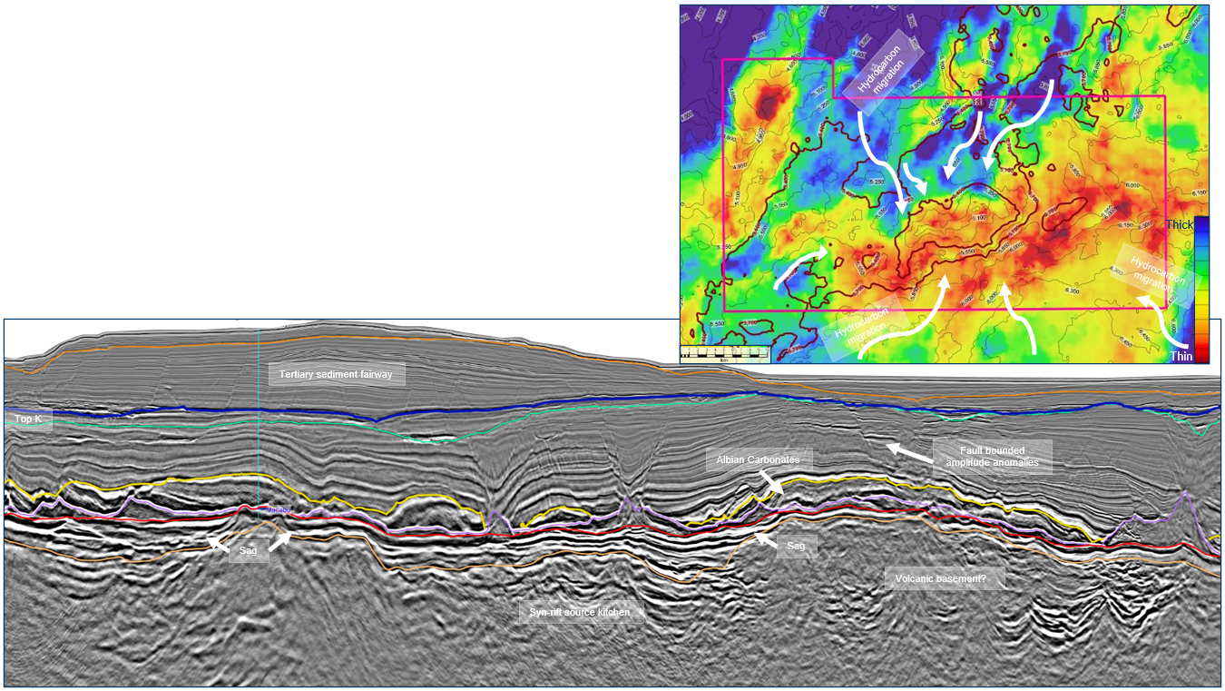
The results of the reimaged, seamlessly merged 3D seismic and subsequent attribute data allow for diverse applications to ILX or frontier exploration. Seismic interpretation and analysis of regional subsurface data supports the evaluation of basin’s geologic history, depositional systems, and paleoclimate as they relate to the offshore petroleum system. Picanha 3D can be used to define these characteristics more confidently by differentiating key features based on broad observations which can be used to interpret hydrocarbon fetch and migration pathways to a high-profile lease blocks, such as Agua Marinha (Figure 1).
One hundred and seventeen datasets were merged and reimaged in a phased approach, from field tape, with a consistent workflow to achieve a contiguous, seamless result. Throughout the imaging process, the team interpreted meaningful, well-tied stratigraphic horizons, not only to calibrate velocity model building, but also to build structure and isopoach maps at major geologic boundaries to evaluate sediment thickness, salt evacuation patterns, and pre-salt carbonate accumulations.
Applying such strategies in the evaluation of high-profile blocks on offer in during the Permanent Production Sharing Offer Round and future ILX territories, gives a substantial advantage to those with access to bulk Picanha licences. Comprehensive maps of the three most distinct isopachs can be evaluated for broad basin architecture and exploration purposes for improved understanding of the heterogeneous petroleum system characteristics across the basins.
Pre-Salt supremacy
The pre-salt isopach reveals where the deepest, most probable source kitchens are present in the syn-rift and sag basins. The underlying continental and transitional crust display horst and graben geometries producing syn-rift accommodation space for kerogen-rich, alluvial sedimentation into the restricted marine lacustrine environment. Structural interpretation, seismic character comparisons, and well-ties suggest the presence of a regional sub-areal volcanic layer at the crest of basement structures within the inner-rift basins however SDR-like volcanic characteristics are found the outer-rift basin.
Campos basin pre-salt thickness averages 2500 m thickness and Santos basin pre-salt average thickness is 1900 m. The basal volcanic unit initiates paleo-environmental conditions for “hydrogen-rich organic matter in the [inner rift] lakes resulting in the deposition of laminated-calcareous black
shales and calcareous shales with excellent source potential” and permeable migration pathways to uplifted, high porosity carbonate reservoirs. Many questions remain in the chaotic, SDR volcanic rift of the outer kitchen in both Campos and Santos Basins where a drastic increase in CO2 is threatening recent development.
Dash of salt
The Aptian Salt isopach (Figure 2) displays halite and layered evaporite thickness for the regional pre-salt reservoir seal and conversely, salt welds which provide windows for hydrocarbon migration into post-salt clastic turbidite systems. In the Campos basin, evaporite deposition occurred in a shallow, restricted marine-platform, flooded, and evaporated during mid-Cretaceous thermal subsidence.
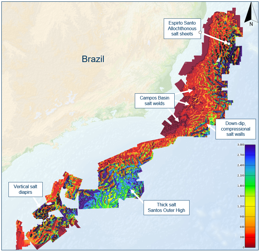
Campos salt is substantially thinner than its southern counterpart in Santos, displaying evidence of sustained pulses of basinward, gravitational salt flow, with deep-water salt walls and ridges reaching up to 4.5 km thick, separated by deep, elongated, mini-basins, welded at the regional base salt level.
In the Santos basin, the 2 to 2.5 km thick, blocky-salt sequence contains sub-parallel seismic reflectors representing evaporites of different chemical makeup, densities, and sonic velocities. These thick and folded, layered evaporites are uniquely isolated to south-eastern Santos, suggesting massive layered evaporite accumulation, filled from groundwater seepage, evaporating in a deep, isolated, adiabatic rift basin.
Potent Post Salt?
The Post-Salt Isopach, which displays the sediment thickness from the water bottom to the Top of Aptian Salt exhibits the mega-sequence of the open marine drift period, including drainage patterns of late Cretaceous depocenters imprinted by down-dip, extensional salt deformation.
Acreage with deep, Upper Cretaceous depocenters in Northern Campos contain post-salt sediment thickness over 4800 m, and in western and southwestern Santos, the post salt thickness reaches upward of 5,500 to 7,500 m, providing evidence of favourable burial history for post-salt source rocks such as the Itajai-Acu formation at the Atlanta field and Ametista Block.
Additionally, thick minibasins in outboard Campos, Espirito Santo and western Santos display complex, allochthonous salt structures signifying he possibility of under-explored play types such as “Gulf of Mexico style” salt flank amplitude truncations. Thorough investigation of these alternate play types may provide a new frontier for offshore Brazil exploration.
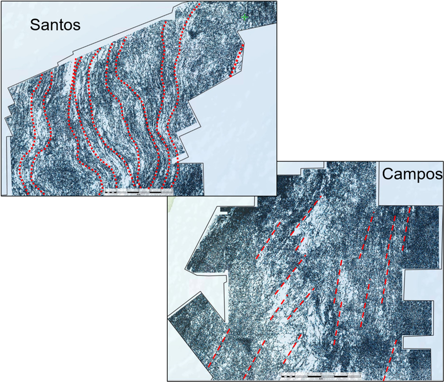
Semblance in “sight”
Lastly, combining these maps with a Semblance attribute extracted along the interpreted basement horizon builds on the regional observations by relating basement fracture patterns to the distribution of sediment, salt, and pre-salt reservoirs. High-density, chaotic semblance trends are possibly related to rifted basement fabric and/or fractured facies that coincide with known reservoirs. We hypothesize that this character
suggests to the presence of rift volcanics at paleo-lacustrine shorelines which controlled the accommodation space for deposition of Barra Velha & Lagoa Feia carbonates. Broad, wavey, and linear differences in the semblance character from basin to basin are likely due to hotspot plume migration through Santos and not Campos Basin (Figure 3).
Up next
The latest chapter of the Picanha story, Phase 7 (see main seismic line above), completed in February 2023. The updated data merges seamlessly into the existing Santos Basin dataset, growing coverage in Northwest Santos Basin and expanding the application of these exploration techniques in both pre-salt and post-salt. As the energy environment and risk appetite changes, new play types will become commercial beyond the traditional outer-high pre-salt play. In preparation for this shift and focusing on ILX initiatives, Phase 7 is well positioned for up-dip, shallow water, inner-kitchen sourced, carbonate and clastic reservoirs in the Albian Gap extensional structural regime. Furthermore, the combination of Picanha with existing TGS Brazilian data library will continue to provide a unique and resilient perspective of Atlantic margin subsurface exploration.
Conclusions
Relating observations from key isopach maps across offshore Brazil and extracting attributes from regional horizons reveals insights that significantly de-risk potential pre-salt and post-salt targets. The recent strategy of merging and reprocessing legacy datasets no longer requires years and costs of permitting, planning, and acquiring new data to determine feasibility of Brazilian petroleum exploration blocks. Instead, the fit-for purpose data allow for a refocusing on the regional scale basin characteristics to revitalize the state of Brazilian exploration.
Acknowledgements
The author would like to thank the processing, imaging team and interpretation teams of TGS, for their hard work and dedication providing the foundation for this study.