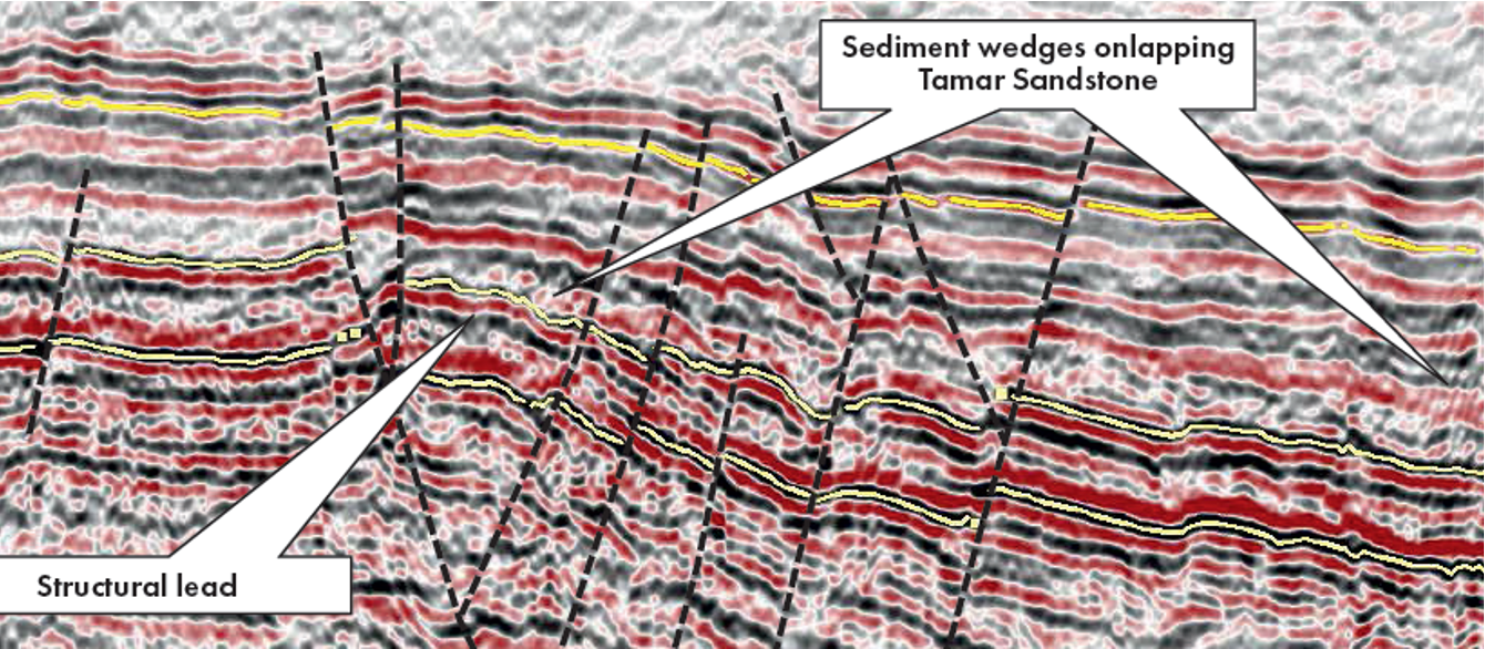
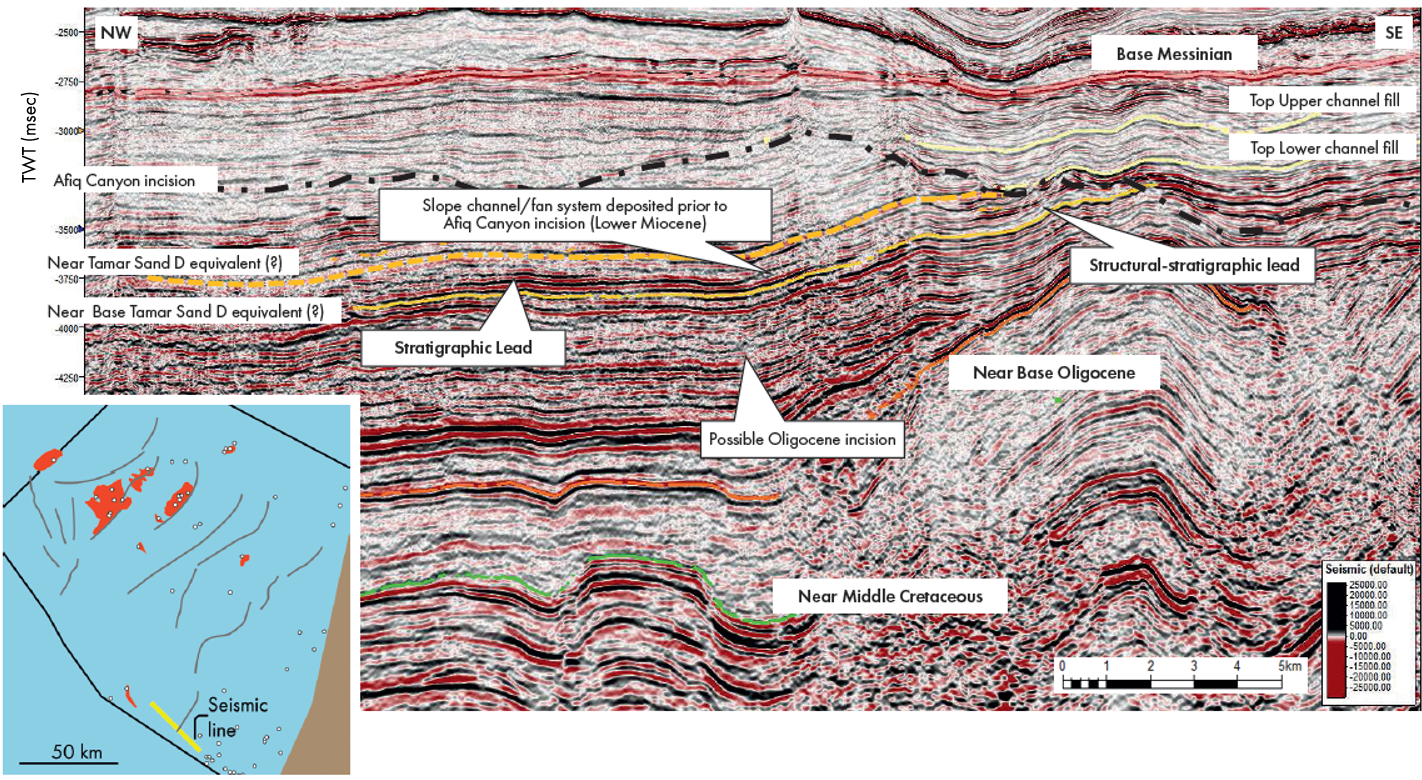
Exploration opportunities in the Israeli offshore. Detail from seismic line shown in Figure 5.
New studies in the Levant Basin offshore Israel
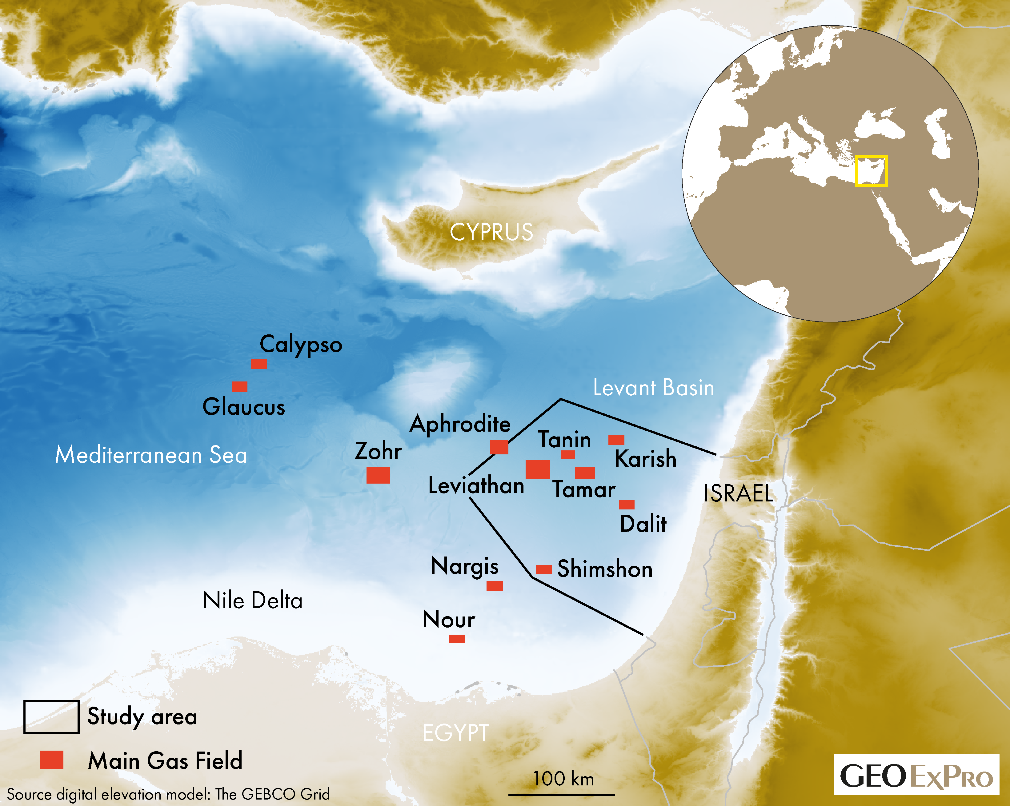
For the past 20 years, hydrocarbon exploration has had an enduring focus in the Levant Basin, with around 85 Tcf (2,400 BCM) of gas (GIIP) discovered during that period. It has re-invigorated activity in Israel, Egypt and Cyprus and opened up new plays.
The Israeli Ministry of Energy has been at the centre of these activities, both from a technology and analysis and interpretation perspective. It has also facilitated recent initiatives and research partnerships, not only involving operators in the area, but also organisations such as BEICIP, Petrostrat, CGG, the Geological Survey of Israel, GaffneyCline and the Ministry of Energy itself.
The results of this work include (1) the review of fundamentals of hydrocarbon plays in the area, including stratigraphic correlation, source models and reservoir concepts, (2) the refinement of the existing principal play and (3) boosting the play and prospect inventory.
The aim of this article is to provide an overview of the conclusions of these projects, which form a foundation for the Israeli 4th Offshore Bidding Round (OBR4), recently launched by the Ministry of Energy.
Opening and closing of the Tethyan Ocean
The geological history of the Levant Basin results from the breakup of Gondwana and the opening and subsequent closure of the Neotethys Ocean. The age of extension is Permo-Triassic to Mid Jurassic. Magmatic activity occurred, but without sea-floor spreading (Gardosh et al., 2010).
Variations in crustal attenuation control basin subsidence and sedimentary facies in the Mesozoic and provide the foundation for the evolution of the Levant Basin. For example, the facies change from onshore and nearshore Mesozoic shelfal carbonates and clastics transitioning into slope-basinal mudstones with turbiditic sandstones offshore.
Late Cretaceous reversal of Tethyan plate motion led to compression in the northern part of the basin. Older extensional features were re-activated, and a series of “Syrian Arc” folds and thrust faults were created, particularly along the eastern margin of the basin (Gardosh et al., 2008).
Doming to the south of the Levant Basin during the Oligocene-Miocene resulted in erosion and transport of siliciclastic sediments into the basin, leading to the deposition of what are the principal gas reservoirs today. Subsequent closure of the Mediterranean Sea during the Latest Miocene led to the partial desiccation of the Levant Basin and deposition of the Messinian evaporite beds.
The main established gas play: Tamar Sandstone and its equivalents
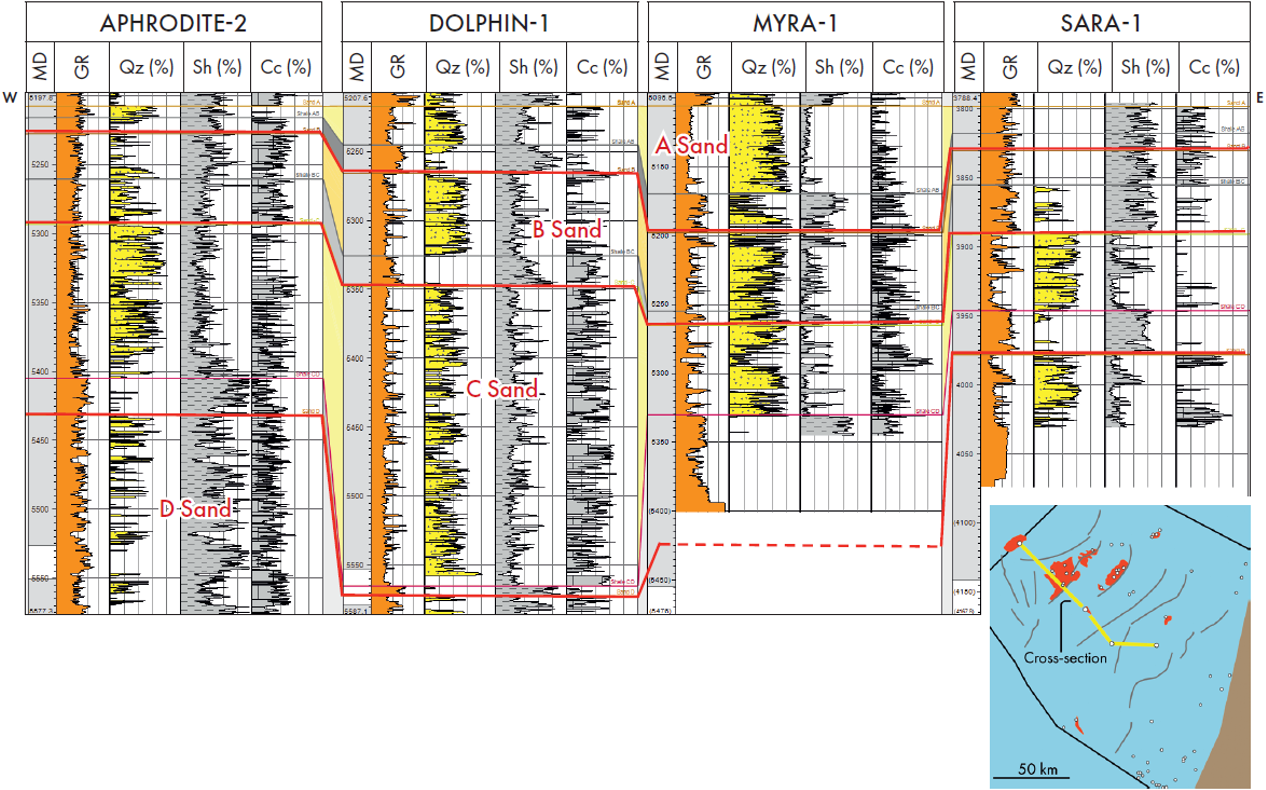
Turbidite sandstones of Oligo-Miocene age (discovered at Tamar-1 by Noble Energy; Figure 1) are the most prolific gas reservoir in the Israeli offshore, of which the net sand thickness can exceed 150 m (Needham et al., 2017). Basin-wide correlation, from the Dalit to the Aphrodite field, shows four distinct sandstone layers (A, B, C and D) and biostratigraphic work confirms these as Aquitanian to Burdigalian in age.
Although the sandstones can be correlated overall, reservoirs range from high net-to-gross, quartz-rich sandstone in the centre, to lower net-to-gross, quartz-poor sediments with greater mudstone and carbonate content at the flanks (Figures 2 and 3; Kachkachev-Shuifer, 2021).
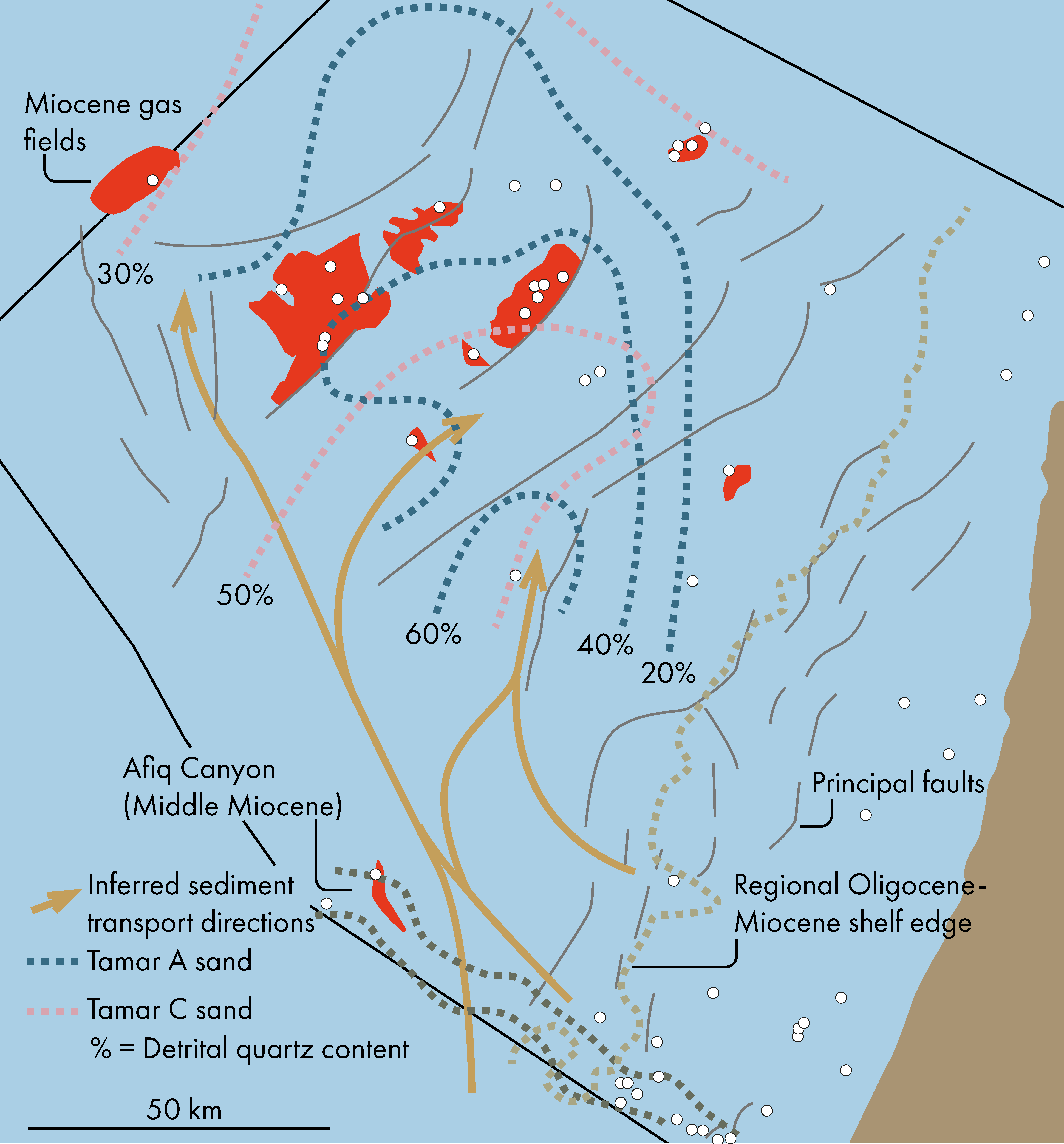
Two controls on sandstone distribution have been previously proposed: (1) a Palaeo-Nile source where sands were transported axially along the basin (Steinberg et al., 2011) and (2) a Levant source where sands were transported across the Levant and Sinai shelf (Gardosh et al., 2008). New mapping of thickness, lithology and mineral composition favours the second model, where, for example, mapping of detrital quartz provides a proxy to define the orientation of the overall system (Figure 3). Regional seismic mapping of the Tamar Sand packages (Top A Sand to CD Shale) shows a 200 – 400 m thick depocentre oriented NE to SW, centered on the Tamar Field (Lippman, 2021).
The inferred sediment pathway aligns with the position of stratigraphically younger sediment fairways along the regional palaeo-shelf edge. For instance, the position of the younger and well-recognised Middle Miocene Afiq Canyon (Figure 3) suggests a long-lived zone of shelf to basin transport. Seismic interpretation has linked the established fields with the Levant and Sinai margins with recognition of possible Tamar correlative units containing candidate channel and lobe complexes (Figure 4).
Additional Cenozoic Plays
Other Cenozoic sandstone reservoirs lie above and below the Tamar Sandstone, and range in age from Oligocene to Late Miocene. As such, these correspond to additional episodes of relative sea level change and/or source reactivation. The age of the younger sandstone units has been confirmed by new detailed biostratigraphic work (Petrostrat, 2021) in offshore wells as Mid Burdigalian, Early Langhian and Serravalian, which places them in a robust regional context of relative sea level change. An even younger phase of sandstone deposition took place during the Tortonian, established by dating in the Afiq Canyon area in the south (Figure 3).
Sandstone systems may be both confined by erosional surfaces (e.g. in the Afiq Canyon) or display an unconfined character. Canyon incision took place in multiple stages from the Oligocene to Early Miocene, and sedimentary fill displays up-dip termination caused by truncation through younger events. Potential traps have a complex mix of stratigraphic and structural geometries. Interpretation of these geometries can be achieved by the simple mapping of reflector terminations but is also supported by seismic amplitudes as well as other seismic attributes such as spectral decomposition and AVO.
Middle to Upper Miocene Plays
The Afiq Canyon Fill is the most important example of this play, but other sand fairways of this age are also thought to be present. The existence of good quality sandstone reservoirs within the Afiq Canyon (Figure 3) fill is demonstrated by several wells; for instance, Shimshon-1 encountered gas within sandstones of Serravalian age. This discovery established the Middle to Upper Miocene play in the basin, which is younger than, and distinctly different from the Tamar Sandstones play.
The play comprises a complex of stacked submarine channels and fans deposited within the overall confines of the Afiq Canyon. Most potential reservoirs have been interpreted within the Mid to Upper Miocene successions, in the latest stages of canyon erosion and fill, partly subcropping the Base Messinian unconformity. However, similar high-amplitude events in the earliest canyon fill may have been overlooked thus far. Interpreted traps are stratigraphic in nature, with fans onlapping onto highs within the canyon, and onto the canyon walls. Lateral facies changes within the canyon fairway into overbank/inter-channel units provide an additional trapping mechanism (Figure 4).
The Afiq canyon system is a long-lived element in the Israeli offshore, but in more distal locations, in the western part of the offshore, detailed seismic stratigraphic, attribute and spectral decomposition work has shown the existence of other more ephemeral channel/canyon systems within the uppermost Middle and Upper Miocene section and at the Basal Messinian unconformity.
Plays below the Tamar Sandstone
Seismic interpretation was also carried out to map sandstones pre-dating the Tamar complex in the southern part of the Israeli Levant Basin. These are distinct as they are developed proximal to the main Tamar depocentre. While sediment provenance is likely to be the same, transport into the basin is probably separate from the channel system sourcing the main Tamar Sand reservoirs. Combination traps have been interpreted, combining lateral facies changes with dip closures and truncation at the base of the Afiq Canyon. Channel incision and levees are visible on seismic and locally coincide with amplitude anomalies where areas of channel incision display the brightest amplitude response (Figure 4).
New plays in the Tamar Sandstone
In addition to sedimentary process, there is also a structural picture emerging. Established fields such as Leviathan and Tamar comprise ancestral, NE-SW trending Mesozoic highs, that have undergone reactivation during the Latest Cretaceous to Miocene “Syrian Arc” event. In the area between these highs, there is a complex of further fault trends across the basin, mostly conjugate to the main NE-SW structures, which are important in focusing structural activity, especially during episodic wrench tectonics and uplift. In part, these faults are manifested as short sub-parallel swarms of NW-SE striking faults at Miocene level, often termed as the “Piano Key” fault system (Joffe et al., 2022, Ministry of Energy, 2022).
Major Mesozoic faults exert direct control on Miocene faults, for example on the northern side of the Leviathan Block. Here, normal fault splays exhibit flower structure geometries that merge downwards and laterally into the North Leviathan Fault, suggesting a dextral motion on the master fault (Figure 5). Subsequent uplift of the main block led to formation of onlapping sediment wedges.
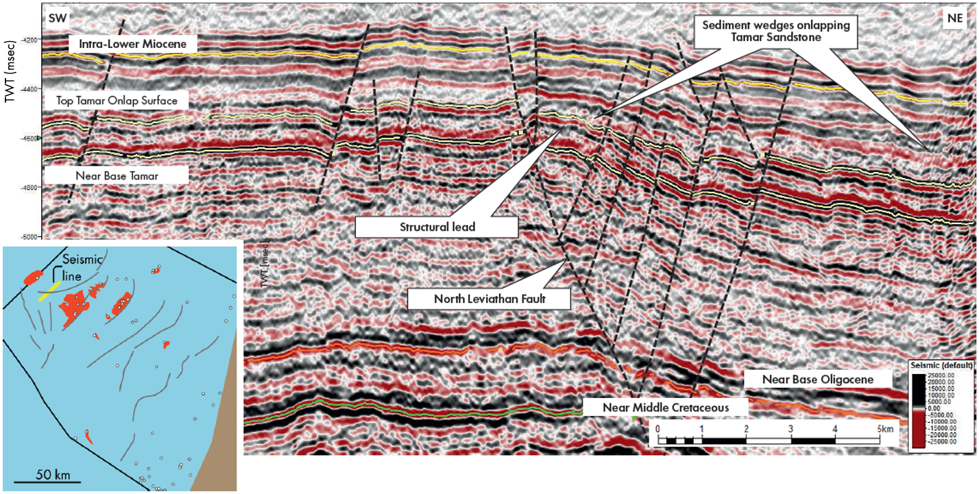
Elsewhere, rather than relating to a deeper master fault, Miocene fault patterns show more distributed arrays. Each consists of SW and NE-dipping normal faults, separated by oblique transfer zones, across which the sense of dip can change. Faults appear to nucleate within the Tamar Sandstone interval, soling out upward within the Middle Miocene. Downwards, the faults sole out at various stratigraphic levels, but commonly within the Oligocene. The overall sense of shear observed supports an anticlockwise rotation of the Leviathan Block, cf. Steinberg et al. (2018).
The detailed interpretation of faulting not only supports the understanding of basin kinematics, but also defines potential hydrocarbon traps, in combination with onlapping sediment wedges onto the major highs. It is significant that the main intervals of structural activity appear to have taken place both before and after the deposition of the main Tamar Sandstone and are therefore expected to contain correlative submarine sandstones within the Aquitanian to Burdigalian.
Petroleum systems
Biogenic gas is a proven hydrocarbon source offshore Israel and has charged most of the Cenozoic reservoirs. However, there is also evidence of thermogenic gas and oil generation, charged from Mesozoic source rocks in the eastern part of the basin. For example, high condensate-gas ratios from samples in the Karish field, in the north, point to more widespread liquid-prone (thermogenic) source rocks in the Mesozoic section. A new database of source rock data has been compiled by the Geological Survey of Israel (GSI, 2021), which demonstrates several intervals of oil and gas prone source rock in the Jurassic, Lower and Upper Cretaceous. This is expected to pave the way for better future modelling of kitchens for the deeper, more distal parts of the basin.
An active hub
The Eastern Mediterranean area, and in particular offshore Israel, remains an active hub of research and exploration. New integrated studies have improved the understanding of the basin’s geological history and have led to expansion of the play and lead inventory for future exploration and development activity.
New work is not only expected to maximise the economic exploitation of resources, it also facilitates possible future carbon storage projects now that the distribution, control and properties of the main sandstone units are much better known.
References
Gardosh, M., Druckman, Y., Buchbinder, B. and Rybakov, M., 2008. The Levant Basin Offshore Israel: Stratigraphy, Structure, Tectonic Evolution and Implications for Hydrocarbon Exploration: Geological Survey of Israel, p. 118. Report GSI/4/2008.
Gardosh, M.A., Garfunkel, Z., Druckman, Y., Buchbinder, B., 2010. Tethyan rifting in the levant region and its role in early Mesozoic crustal evolution. Geol. Soc. Lond. Spec.Publ. 341, 9–36.
Geological Survey of Israel, 2021. Geochemical Evaluation of Mesozoic Source Rocks and their Potential to Support Petroleum Systems, Israel Continental Shelf
Joffe, A., Jackson, C. A-L, Steinberg, J, Bell, R.E. and Makovsky, Y, 2022. Origin and kinematics of a basin-scale, non-polygonal, layer-bound normal fault system in the Levant Basin, eastern Mediterranean. Pre-print submitted to Basin Research.
Kachkachev-Shuifer, M., 2021. Tamar sands properties within the Levant Basin from core analysis and upscaling to wireline log interpretation. Internal Report, Ministry of Energy, State of Israel.
Lippman, S., 2021. Seismic Mapping of the Upper Oligocene to Lower Miocene Turbidite Sand Package in Israel EEZ. Internal Report, Ministry of Energy, State of Israel.
Ministry of Energy, 2022. Promotional montages in support of Offshore Bid Round 4 (OBR 4). Prepared in conjunction with GaffneyCline.
Needham, D.L. and four others, 2017. The Tamar Giant Gas Field: opening the subsalt Miocene gas play in the Levant Basin. In: Giant fields of the decade 2000-2010, AAPG Memoir 113, p. 221-256.
Petrostrat, 2021. Biostratigraphic review study of the Miocene intervals from selected wells, Levantine Basin, offshore Israel Report produced for Israel Ministry of National Infrastructures, Energy and Water Resources
Steinberg, J., Gvirtzman, Z., Folkman, Y., Garfunkel, Z., 2011. Origin and nature of the rapid late Tertiary filling of the Levant Basin. Geology 39, 355–3
Steinberg, J., Roberts, A.M., Kusznir, N.J., Schafer, K. and Karcz, Z., 2018. Crustal structure and post-rift evolution of the Levant Basin. Marine and Petroleum Geology, v. 96, p. 522-543.
