A hibernating giant?
The new long-offset data reveals insights into crustal architecture.
Northern Argentina has a continental volcanic rifted margin, segmented by major transfer zones which reflect the pre-existing Gondwanan structural fabric. The individual rift basins along this margin initially formed from intracratonic rifting within the paleo-continent of Gondwana during the middle Mesozoic, and evolved into a true passive margin following the separation of the South American plate from the African plate in the early Cretaceous. The evolution of the Argentine margin was far more complex than had been previously understood.
Only 26 exploration wells have been drilled on the northern margin (north of 47°S), with none in water depths greater than 100m and all located at least 15km inboard from the continental shelf edge. The last offshore well in this area (Pejerrey x-1) was drilled by Shell in 1997. During the mid-1990s, a handful of wells were drilled, mostly by major oil companies, without any commercial success.
Recent academic work has focused on understanding the opening of the South Atlantic Ocean, rifted margins, and ocean basins. This work, combined with industry exploration in other deepwater, rifted passive margins around the world, has led to a much better perception of the Argentine margin for future exploration.
Seismic observations
Crustal Architecture: Long-offset seismic data acquired with a 12 km cable has enhanced the Moho signature significantly. Interpretation of the Moho has allowed us to develop conclusions about the nature of the crust and the position of the continent ocean transition zone (COT). Seaward Dipping Reflector (SDR) zones are easy to distinguish on the high quality seismic dataset and the varying acoustic signature and thickness of different SDR packages allow us to make inferences about the volume of magmatism at the time of rifting. Transfer zones observed on strike lines cut by numerous strike-slip faults appear to correlate with thinning and offsetting of these volcanic SDR packages. The imaging at depth outboard in the deep basin is of high quality, allowing clear identification of SDRs quenched by first flooding and the onset of oceanic crust.
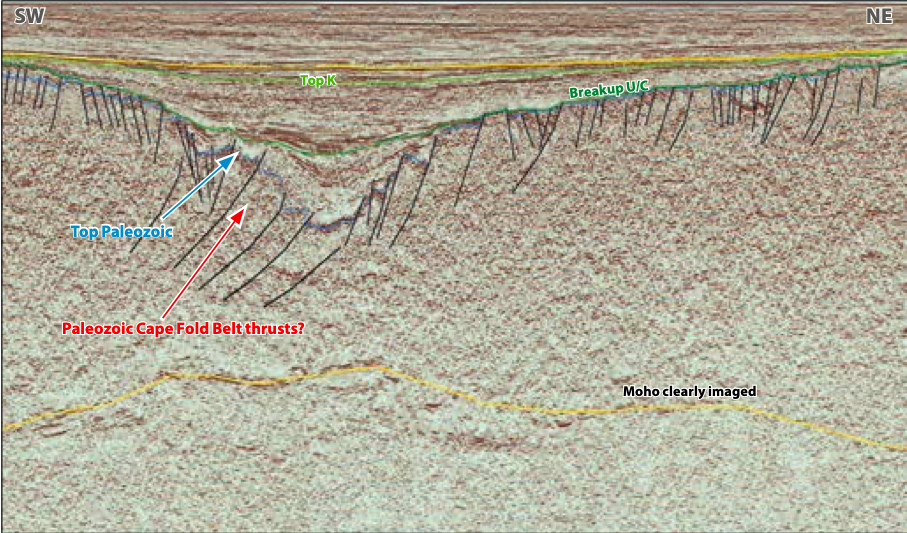
Pre-Rift Structuration – Shallow Water Potential: Pre-rift structuration is associated with orogenic events from the Neoproterozoic, Cambro-Ordovician and the Permian. Onshore, in the Sierras Australes, pre-rift rocks exhibit box fold structures which evidence these compressional events, and we can trace similar events in the seismic data extending into the offshore region. Many structures have been eroded at the break-up unconformity level but the forelimbs and backlimbs of the folds are still present. This truncated stratigraphic relationship as well as the uneroded anticlines may act as hydrocarbon traps sourced by Permian, Carboniferous, and Early Cretaceous syn-rift source rocks.
The Colorado and Salado Basins that formed following north-west to south-east extension prior to the east/west extension that resulted in the opening of the South Atlantic can be clearly seen superimposed on the predominantly compressional pre-rift architecture (see figure top of page 54). Multiple syn-rift packages within grabens are well imaged on these lines and have been recorded in wells.
License round information
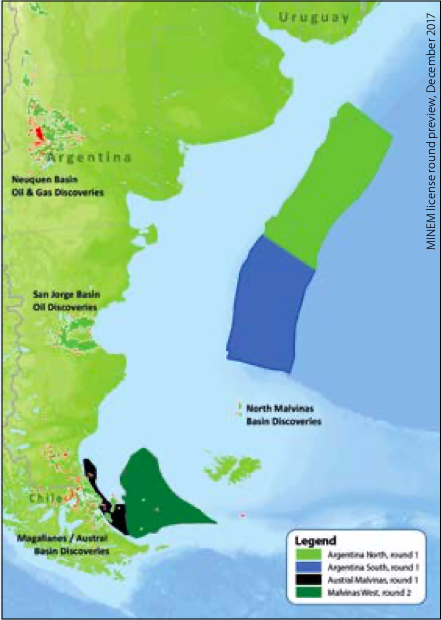
In December 2017, the Argentine Ministerio de Energía y Minería previewed the first new offshore Argentina license round in more than 20 years. In 2018 two large areas will be opened to tender: the northern deepwater Argentina Basin and the offshore Austral and Malvinas Basins. This will be followed in 2019 by a license round covering the southern deepwater Argentina Basin.
For the northern deepwater Argentina Basin and the Austral and Malvinas Basins, the official opening is planned for July 2018, with bids due in late November 2018. Final regulations on qualification, block size, work programs and fiscal terms will be published with the official declaration.
Post-rift deposition – deepwater potential
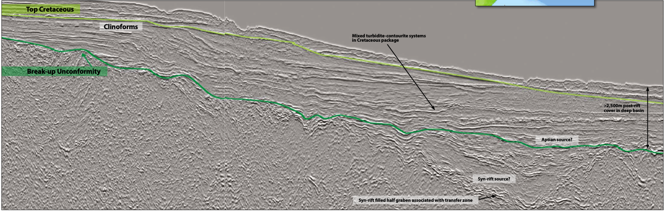
Further offshore there is seismic evidence that tilted fault blocks are present inboard from the inner SDR packages, and a Kudu- type play may exist within continental sands interbedded with flood basalts, sourced by syn- or pre-rift organic-rich sediments. Just above the break-up unconformity we can identify a thin, acoustically opaque but laterally extensive package which bears a striking resemblance to the prolific Aptian-age source rock on the conjugate Namibian and South African margins (see main foldout line). Approximately 2,500m of post-rift cover is present in the deep basin, providing sufficient burial for source rocks to mature.
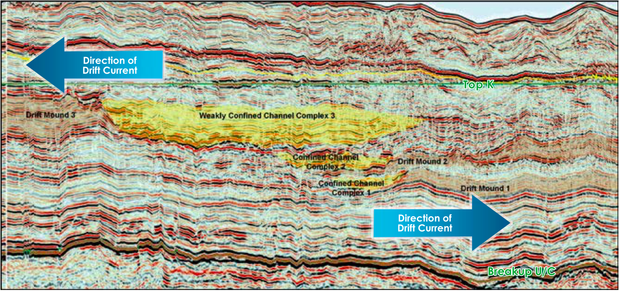
This presents a case for a high quality source rock with sufficient burial depth to generate hydrocarbons overlain by numerous stacked, mixed turbidite-contourite drift mounds and confined channel complexes throughout the Cretaceous and Cenozoic. These clearly demonstrate the alternating dominant bottom current directions at the time of deposition (see below). Drift mounds comprise predominantly muddy, fine-grained silty sediments, whereas the intervening confined channel complexes are likely to consist of coarse-grained well-sorted sands with high net: gross – ideal reservoirs for hydrocarbon accumulations. Acoustically opaque packages are also identifiable during periods where ocean currents were apparently much weaker in the Paleogene and Cenomanian-Turonian, when the depositional environment in the deepwater setting would have been ideal for source rock deposition.
Extraordinary structures revealed
Newly acquired long-offset seismic data offshore Argentina reveals extraordinary structures in a margin that has remained underexplored. The potential for deepwater source rocks is ever-present, and the data provides exciting insights into the pre-Cretaceous continuation of the Cape Fold belt from South Africa, with excellent images of rift grabens and large contourite deposits. The upcoming licensing round in May 2018 has the potential to make Argentina the new South American giant in oil and gas exploration.