
GeoStreamer X innovative acquisition design and advanced processing
Key to enhanced subsurface imaging
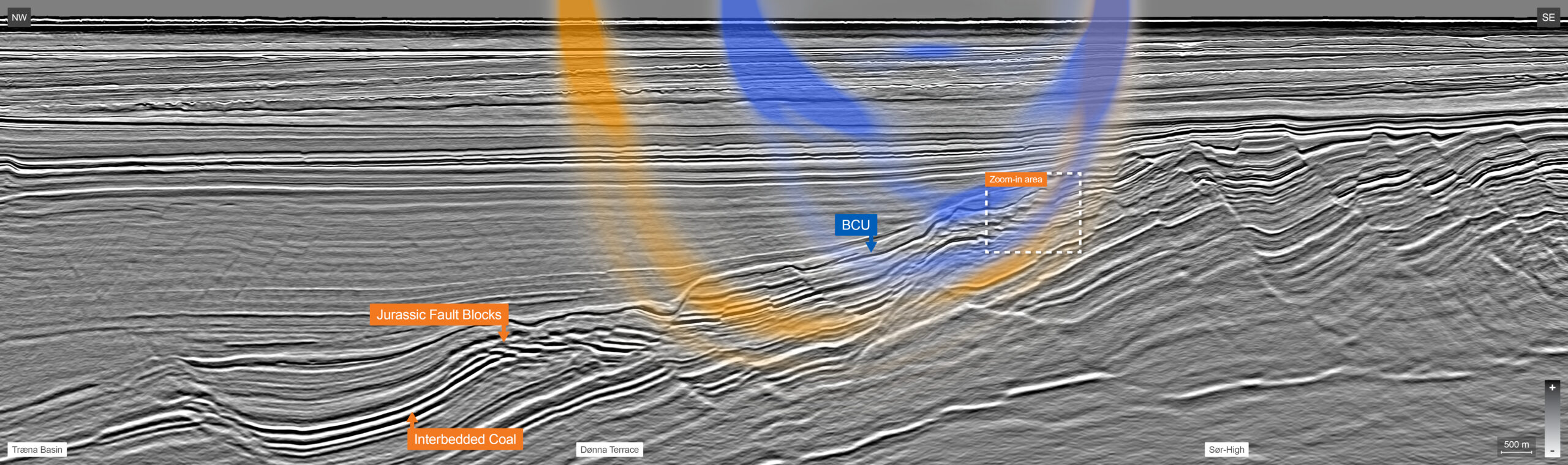
The Norwegian Sea is renowned for its high-quality hydrocarbon reservoirs situated within complex geological settings. Tilted fault blocks, formed during Late Jurassic rifting, host prolific pre-rift petroleum plays, characterized by high-quality Jurassic sandstone reservoirs located in structural traps. Recent advances in seismic processing deliver improved data quality and have redirected attention toward marine post-rift deep-water clastic systems and stratigraphic traps within the Cretaceous section. Looking ahead, the drilling will continue to focus on more complex accumulations for both exploration opportunities and potential field development extensions. A critical factor in evaluating these opportunities lies in high-resolution, AVO-friendly seismic data that provides comprehensive subsurface illumination beyond what single azimuth data can offer.
GeoStreamer X: From acquisition innovations to superior image
The 2022 GeoStreamer X acquisition program covers an area of approximately 6,777 km2. The acquisition program was designed with an azimuth orientation perpendicular to the existing GeoStreamer datasets acquired between 2011 and 2016. Through a combination of reprocessing existing data and employing state-of-the-art depth imaging techniques, a large scale and uniform multi-azimuth dataset was created for the region.
The innovative GeoStreamer 2022 acquisition configuration employs a wide-tow triple source setup, allowing dense crossline sampling. The source array separation was 250 m between the outer arrays, and the data was recorded using 14 streamers spaced at 75 m intervals (12×7 km and 2×10 km long). The 2 long streamers, referred to as streamer-tails, were extended to achieve longer offsets, which provide greater depths during FWI-based velocity model building. The difference of the depth of penetration between the 7 and 10 km streamers is shown using FWI sensitivity kernels on the foldout line and illustrates the uplift from 10 km-long streamer-tails.
Additionally, the cables are towed as close as possible to the source arrays, allowing near offset reduction to 65 m. These near traces help to improve the de-multiple flow and led to an improved and detailed image in the very shallow overburden. The significantly enhanced near-offset distribution provides further comprehensive azimuthal coverage and together with the already existing GeoStreamer azimuth allows the utilization of all traces together in a regularization scheme.
Improved subsurface risk and uncertainty assessment
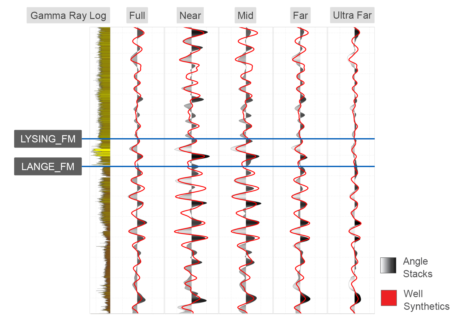
Rigorous control over the Amplitude vs Offset (AVO) behaviour throughout the entire processing sequence has yielded a dataset well-suited for exploration, near-field exploration, infrastructure lead exploration (ILX), and appraisal activities. The final dataset’s quality has been quantitatively assessed by well to seismic ties across 43 wells in both the Cretaceous and Jurassic intervals. The cross-correlation coefficients, averaging over 0.7 on the multi-azimuth full stack, underscore a significant improvement in signal-to-noise ratio when compared with single azimuth legacy data. This uplift is particularly evident in low-reflectivity Cretaceous sections, as illustrated in the well-to-seismic tie panel for the 6406/3-9 well shown in Figure 1.
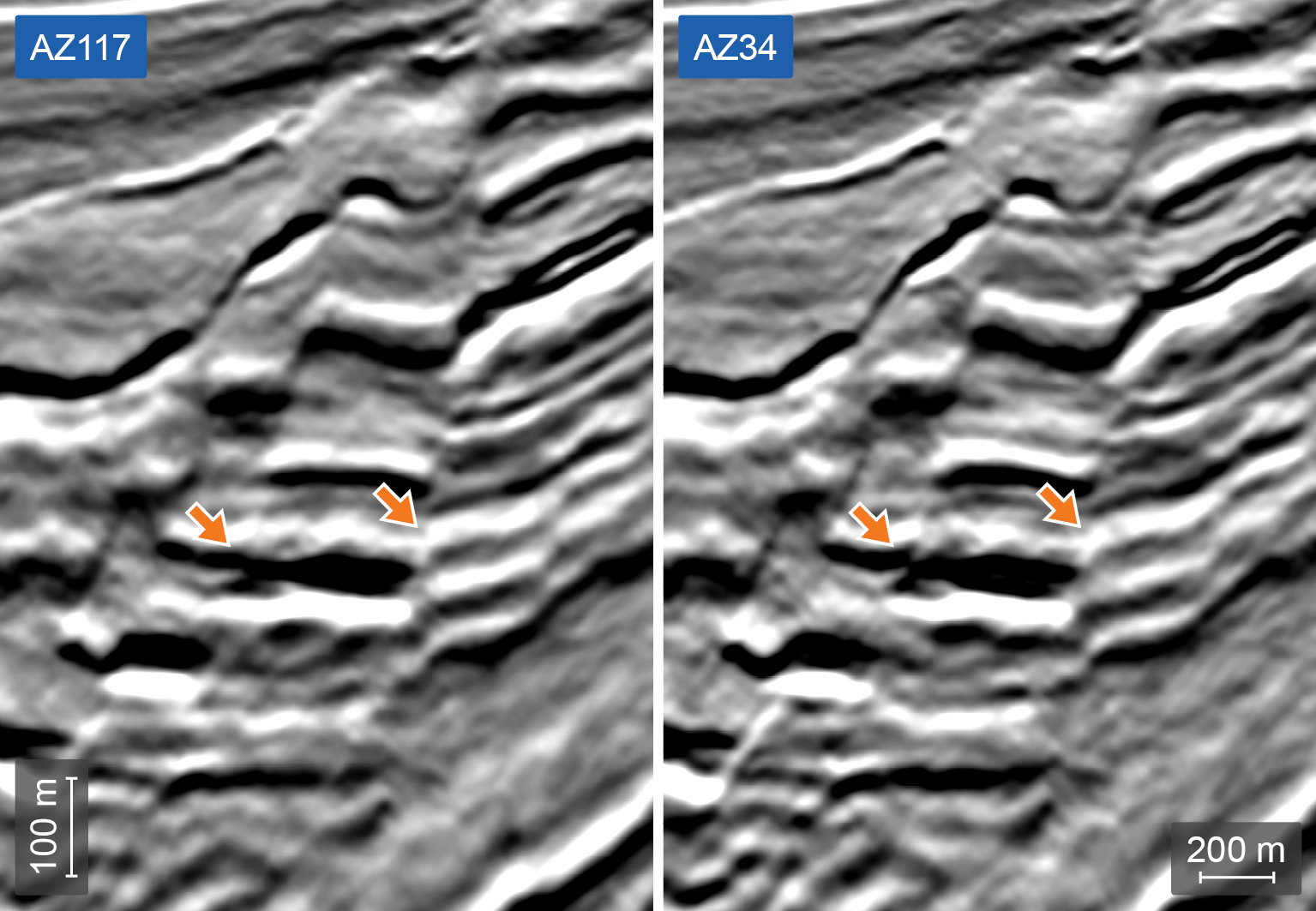
Improved GeoStreamer X multiazimuth illumination leads to significant enhancement in structural and stratigraphic imaging in both the Jurassic and Cretaceous sections. Fault plane imaging depends on illumination direction and in some cases, minor fault features that are not visible on the single azimuth data become apparent. The estimation of fault offset magnitudes can also depend on the illumination angle – one zoom-in example from the foldout line (marked with a rectangle) is presented here in Figure 2. Analysis of this new perspective can lead to better structural fidelity and structure uncertainty understanding, and consequently to improved appraisal of e.g. trap geometry, block compartmentalization, and fault property estimation.
The new data represents a significant advancement to unlock the full Cretaceous potential. It allows interpreters to investigate subtle structural features that constrain and compartmentalize prospects. The true value of this lies in enhanced trap geometry analysis and reservoir characterization, which accurately captures prospect segmentation and internal reservoir continuity.

GeoStreamer X helps unlock remaining prospectivity
To further assess the remaining prospectivity within the area, the dataset was inverted in a pre-stack simultaneous inversion scheme to P-Impedance and Vp/Vs. Furthermore, by leveraging PGS’ comprehensive petrophysics and rock physics rockAVO library, stochastic depth dependent rock physics modeling of Cretaceous and Jurassic intervals was conducted. The inversion results were subsequently classified using a Bayesian scheme in terms of the most likely lithology-fluid class.
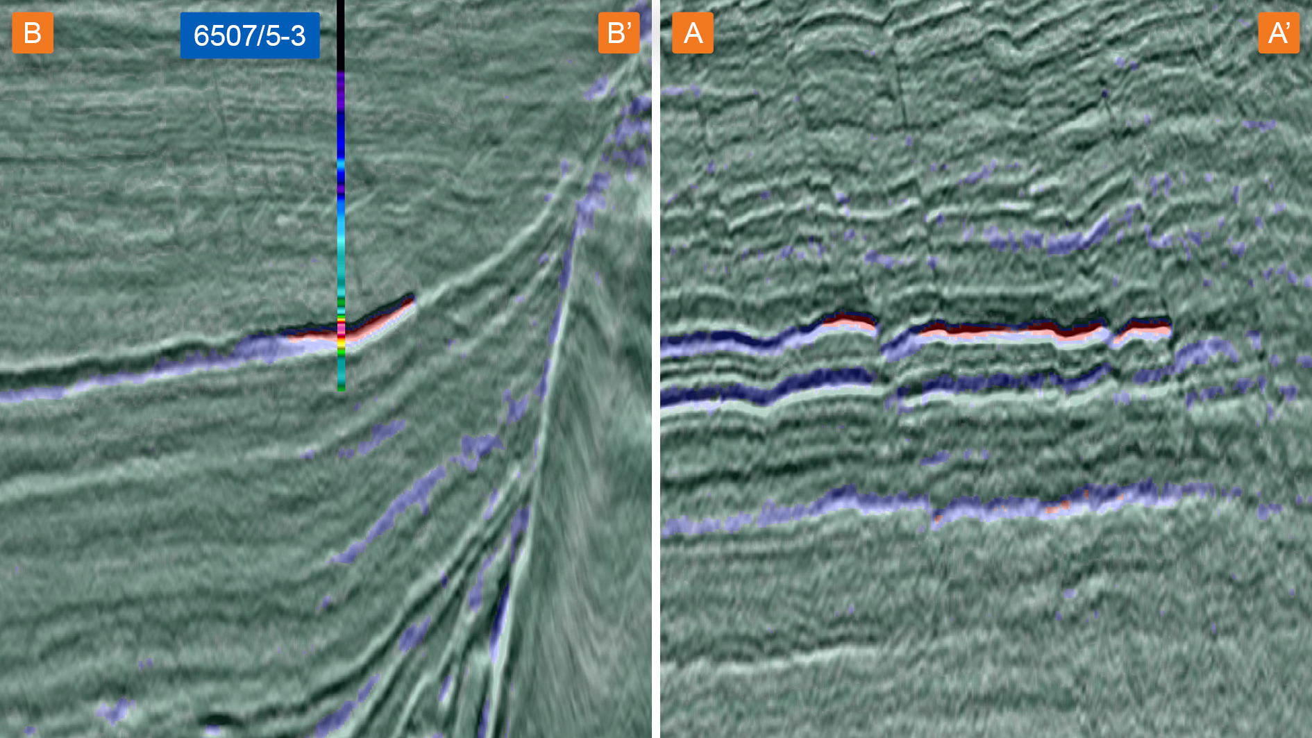
The facies classification process integrates both seismic and well information, yielding a probabilistic description of the subsurface. These results correlate well with known accumulations, the Ærfugl litho-fluid classification line through discovery well 6507/5-3 is presented on Figures 3 and 4 (left), together with the identified prospect Figure 4 (right) – and provides further reassurance regarding hydrocarbon fill as a cause of the prospects anomalous seismic amplitude and AVO response.
In the Jurassic, there is potential for added reserves in existing developments and discoveries. Figure 5 shows Well 6507/10-2 (Novus discovery well) drilled by Faroe Petroleum Norge in 2014 about 13 km south of the Heidrun platform encountered oil and gas (24,5 m column total) in a reservoir with better-than-expected quality. After resources evaluation, the discovery was deemed non-commercial – despite easy tieback to Heidrun facilities.
After our analysis of the inversion results and litho-fluid classification, we reveal the possibility of added resources in a down-thrown fault block. The litho-fluid classification in the existing discovery agrees very well with hydrocarbon column height encountered in the well. If confirmed, a similar 50 m hydrocarbon column in the downthrown block within the Middle Jurassic Garn Fm. reservoir would affect subsurface volume estimation and the economics which could in turn result in development plans being brought forward. A similar but small anomaly in an underlying section suggests the presence of additional reserves at deeper stratigraphic levels.

GeoStreamer X solves exploration challenges
Through a small number of example extractions, we have demonstrated how an innovative acquisition set-up with wide-towed sources and a state-of-the-art depth imaging workflow, result in a high quality, multiazimuth broadband seismic dataset that has the potential to help overcome the main exploration challenges in the Norwegian Sea. Adding a second perspective/illumination direction allows for the assessment of the uncertainty in fine structural details and delivers a significantly improved understanding and characterization of shallow to deep reservoirs. Leads and opportunities suitable for near-field exploration have been mapped using an integrated quantitative interpretation workflow. There are many more to be unraveled!


