Hydrocarbon Potential of Offshore Namibia
In 2012 and 2013, PGS shot approximately 15,000 line km of broadband seismic data in the deep and shallow waters offshore Namibia, with a view to enhancing geological understanding of the margin and de-risking exploration in this frontier part of West Africa.
Frontier basins of West Africa have experienced a growing demand for high quality seismic data in a regional context in order to de-risk exploration. Deepwater basins offshore Namibia appear increasingly promising and recent wells drilled by Petrobras, HRT and Chariot have confirmed the elements of a working petroleum system for the first time. More wells and continued seismic acquisition are planned for 2014 and the area is set to have an exciting future.
De-risking exploration
To date, exploration offshore Namibia has been rather limited. Along a margin with an area covering 670,000 km2, only 12 wildcat wells have been drilled. In the last few years, however, a renewed drilling campaign has resulted in a suite of modern seismic and several dry wells. The information gained from these drilling programmes has improved knowledge of the area substantially and has provided key insights into the working petroleum system. The wells which have provided the greatest insights were the Kabeljou-1, Moosehead-1, Murombe-1 and Wingat-1.
To better understand the petroleum systems of offshore Namibia, PGS in association with NAMCOR, the national oil company of Namibia, acquired two 2D surveys using the GeoStreamer® with GeoSource™ dual-sensor broadband towed streamer system. The first of these surveys was in 2012, with 5,000 line km acquired over blocks 2112B, 2113 A&B and 2413B, and in the second, in 2013, 10,000 line km of regional 2D were obtained, focused in deepwater Namibia.
Several source rocks
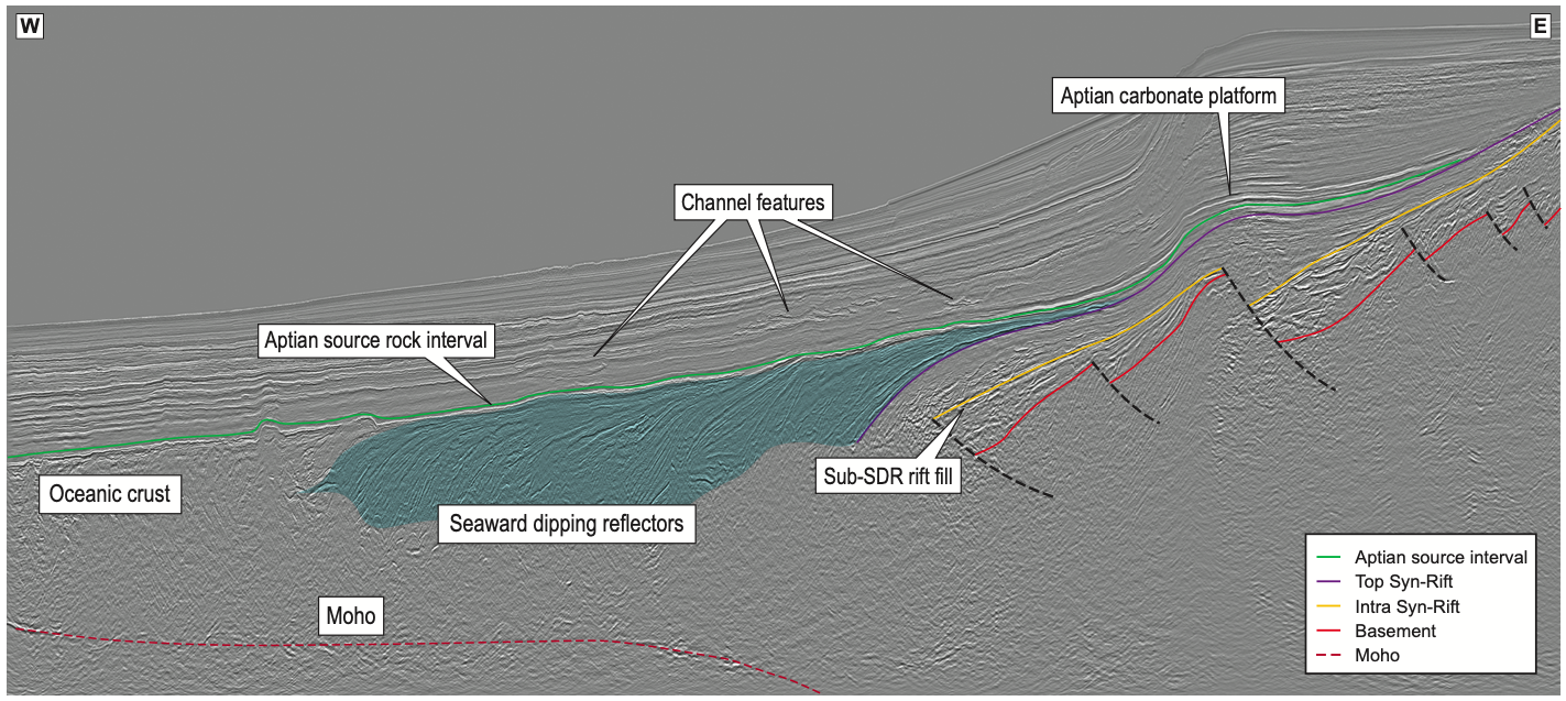
The oldest known source rocks in Namibia are Karoo-aged coals and carbonaceous shales, found in the coastal well Toscanini-1 in 1972. Offshore, the prevalence of this source rock remains unknown. The oldest proven source rock tested by offshore wells is found in the Kudu Field and is believed to be lacustrine syn-rift in origin, equivalent to the prolific Bucomazi Shales. Offshore South Africa, the effectiveness of syn-rift lacustrine source rock is demonstrated in the AJ-1 discovery (1988). In the Aptian post-rift section, marine shales, interpreted to be deposited as part of Oceanic Anoxic Event (OAE) 1a, were encountered in Kabeljou-1, Wingat- 1, Murombe-1 and Moosehead-1. In Wingat-1, the interval was apparently oil mature, with small samples of light, and 38 to 42 degree API oil recovered.
Another potential major source rock is the Cenomanian- Turonian shales associated with OAE 2. Encountered on the shelf by well 2012/13-1 with Total Organic Carbon (TOC) content of 5%, the shales were thermally immature, but indicated the possibility that, where sufficiently buried, they could generate hydrocarbons.
Syn- and post-rift reservoirs
Early Cretaceous late syn-rift reservoirs have been proven by the Kudu Field. Interestingly, the original reservoir target for this field was in the Upper Cretaceous post-rift, but poor reservoir results in the post-rift led Chevron to drill deeper into the syn-rift. The reservoir at Kudu is complex, with development being hampered by high pressures and porosity and permeability reduction. These complexities, combined with commercial export issues, have led to stagnation of development from the initial discovery in 1974 to anticipated production by 2017. The reservoir lithology is Neocomian Aeolian sandstones, with porosity and permeability values reaching up to 20% and 767 mD respectively, and preservation at depth due to early calcite cementation and secondary porosity generation due to leaching. The deeper syn-rift remains untested, though thick packages are clearly visible on seismic data.
Aptian carbonates have been proven in Namibia by recent drilling campaigns. However, good quality reservoir has proved difficult to find. The primary target of HRT’s Wingat-1 was a high amplitude interval interpreted as a set of prograding carbonates – the well did encounter carbonates, but found only low quality lime muds. Moosehead-1 also targeted a fourway- dip closed carbonate of Aptian age which failed due to a lack of porosity development. Understanding these carbonate systems is difficult, but as exploration increases, so does comprehension of the geology, and thus a more detailed picture of facies distribution will begin to unfold. This allows more focused targeting of good quality carbonate reservoirs.
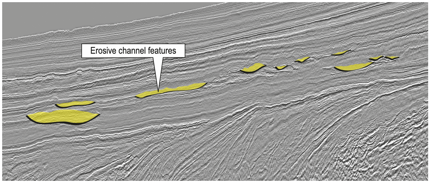
The final and perhaps the most promising reservoirs are the Late Cretaceous turbidite channel and fan systems with up-dip stratigraphic and structural traps. The secondary target of Murombe-1 was a Santonian-age channel complex and although water-wet, the 36m of net sand within a 242m interval had an average porosity of 15%. These types of traps are becoming a common target around the world and there are some significant problems to overcome – not least finding a working trapping mechanism and defining migration pathways from source to reservoir sandstones.
Seal and trap
An adequate seal is perhaps the final piece missing in the Namibian jigsaw puzzle. Many of the wells drilled offshore Namibia have had good evidence of source and reservoir, but have only had hydrocarbon shows. In wells located on the shelf, thick clastic sequences have been found with very little shale to act as a seal for the sandstone reservoirs. On the other hand, some wells have encountered the opposite problem – thick shale sequences with little sandstone.
There is clearly plenty of shale in the Namibian system. As exploration is focused offshore and into deeper waters, the presence of shales will be almost guaranteed and the risk of seal failure will be significantly reduced.
Exciting future
Even the brief analysis of the petroleum system presented in this article shows that offshore Namibia has an exciting future for hydrocarbon exploration. Although dry, the recent wells have proven several previously unknown elements of the petroleum system.
Broadband seismic has improved the imaging of syn-rift and post-rift structures, enabling more confident identification and mapping of prospects. These data clearly demonstrate the presence of thick syn- and post-rift packages and thick sediment in deep water. The improved imaging and resolution provided by this type of seismic acquisition significantly de-risks exploration in frontier areas, something that is of high importance where well costs are extremely high.