Mozambique’s deepwater Zambezi Basin: Where AVO meets untapped opportunity
Integrating AVO analysis into frontier workflows to identify exploration opportunities
Assessing frontier basin prospectivity with limited subsurface data presents significant challenges in evaluating its petroleum potential. As well data is often sparse or absent, it becomes essential to acquire and interpret high-resolution 3D seismic data to build knowledge of petroleum systems and plays.
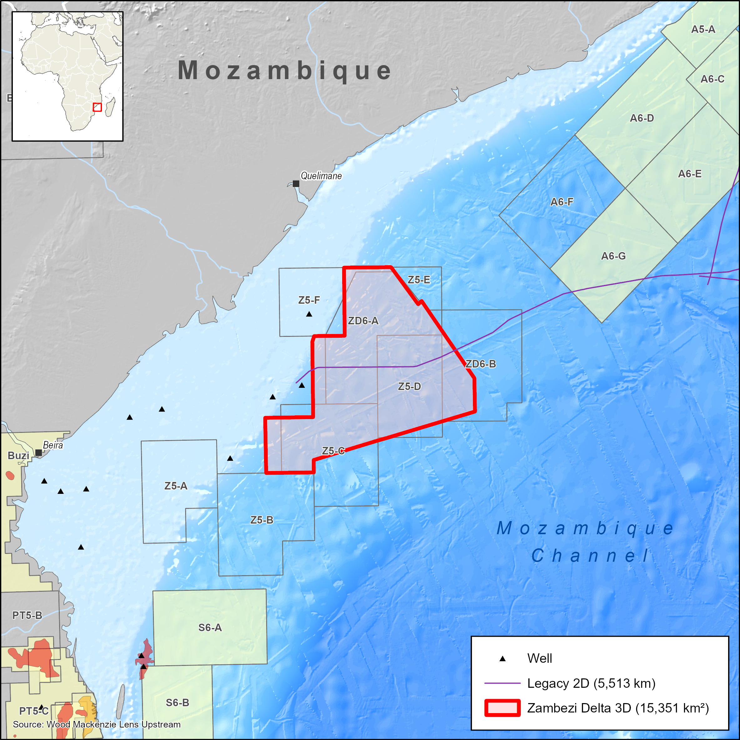
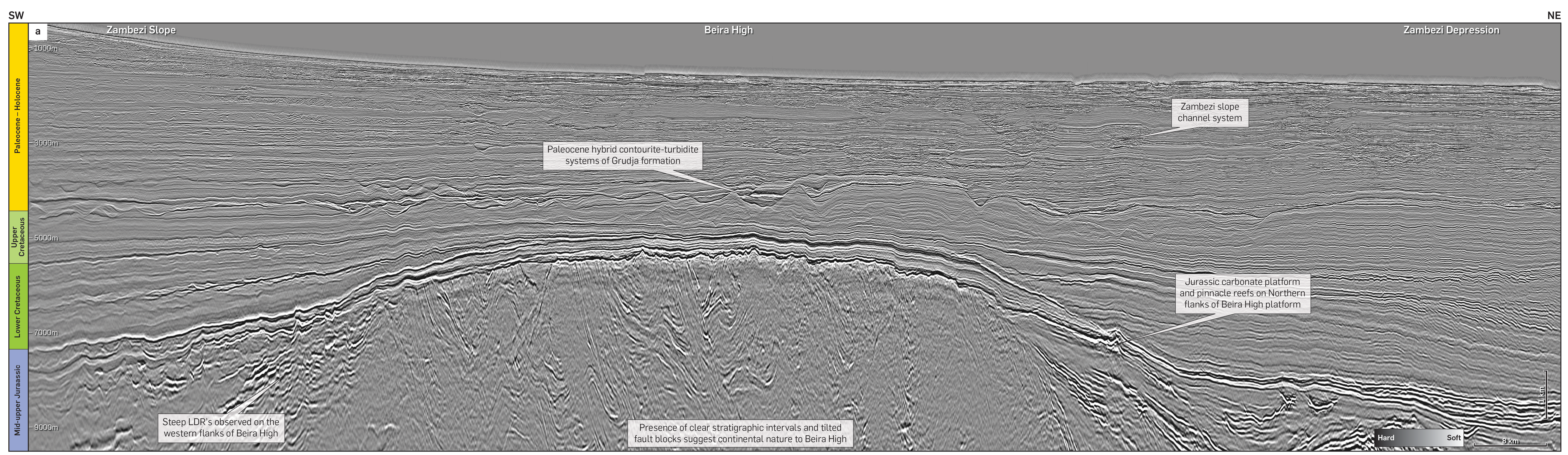
To further enhance our understanding of the Zambezi Basin, Viridien recently conducted a regional AVO screening study on its 15,000 km2 3D seismic survey. Several plays have been identified in the post-rift sequences of the deepwater Zambezi Basin ranging from Upper Jurassic to the Oligocene-Holocene play. The study focused on hybrid turbiditic-contourite channels of the Paleocene Upper Grudja formation with an aim to assess fluid characterisation and better understand rock physics to delineate zones of prospectivity within this interval.
Paleocene reservoirs
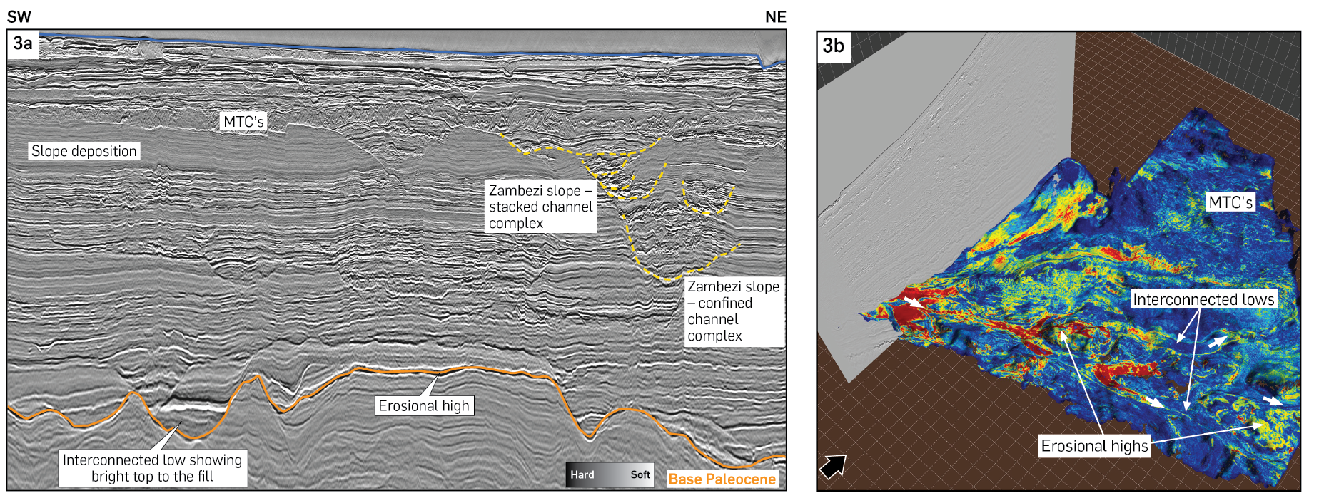
The Paleocene Upper Grudja formation is considered to have reservoir potential with sedimentation occurring largely within a slope setting. The Upper Grudja formation within the southern part of the survey area is characterised by migrating channel levee complexes indicating synchronous interaction of downslope-flowing turbidity currents and along-slope contour currents (hybrid channel systems). These hybrid channel systems were strongly controlled by the position of the pre-existing Upper Cretaceous contourite drifts and moats. The reservoirs consist of thick channel deposits (Figure 3a) with potential vertical connectivity. An RMS map of the Base Paleocene (Figure 3b) shows the distribution of potential reservoir sands, some of which exhibit a high-amplitude response within the connected lows of the hybrid channel systems in the south of the survey. These reservoirs are sealed by fine-grained clastic slope deposits. Hydrocarbon charge is likely to be from Early Cretaceous (Aptian-Albian) and Late Cretaceous (Turonian-Coniacian) source rocks. Traps are stratigraphic and consist of truncations, onlap and ponding within the lows of the channel systems.
From insight to outcome
For the AVO screening, our rigorous workflow included data QC on gathers to assess and condition data for AVO attribute generation, AVO class screening, generation of additional attribute volumes and, finally, geobody picking.
First, a seismic velocity field was required to convert horizons from depth to time. This volume provided a low-frequency trend for impedance estimation. Four angle stacks – near, mid, far and ultra-far – and offset gathers were available for this screening. The data quality of angle stacks was observed to be good with noise well suppressed.
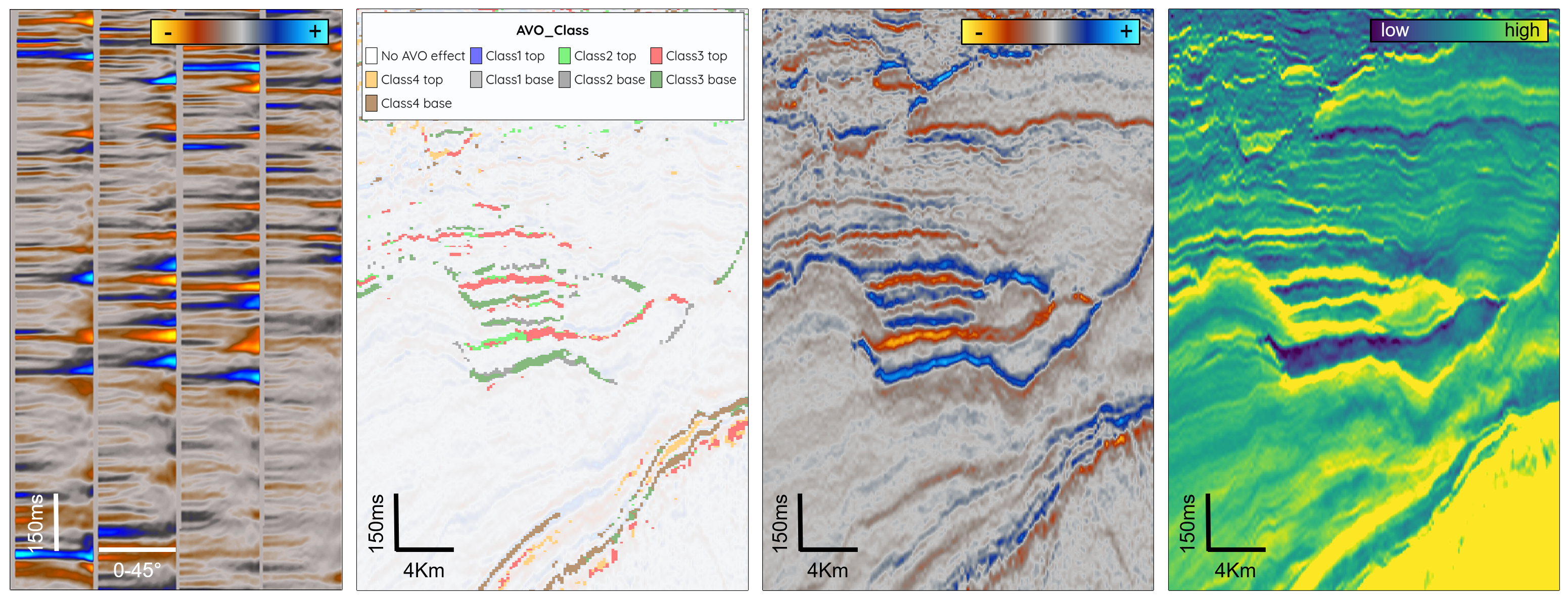
The basic screening attributes were generated from AVO fitting of the data using Shuey and Fatti approximations. Further attributes such as AVO class and chi rotations were generated from the Shuey-derived intercept and gradient, whilst Fatti provided P and S reflectivity. The P and S reflectivity allowed us to generate the fluid factor attribute, and after inverting for P and S impedances, we obtained Lambda-rho/Mu-rho and fluid indicator, any of which can be used as potential hydrocarbon indicators (Figure 4).
Key learnings
The Fatti-derived fluid factor and Shuey-derived chi rotation (20° works best) both identify the same anomalous features, whilst the AVO class display provides further information about the position of the data in the familiar R0/G crossplot space. For this project, we required data that was appropriate for AVO analysis. The data was made more robust using volume-based attributes, preferable to the interface properties provided by the reflectivity attributes. The reflectivity volumes from Fatti were therefore inverted to provide P and S impedances and, from there, the fluid indicator attribute was generated. Rocks containing hydrocarbons instead of brine will tend to exhibit reduced P impedance values and hence low or negative fluid indicator values (Figure 5a).
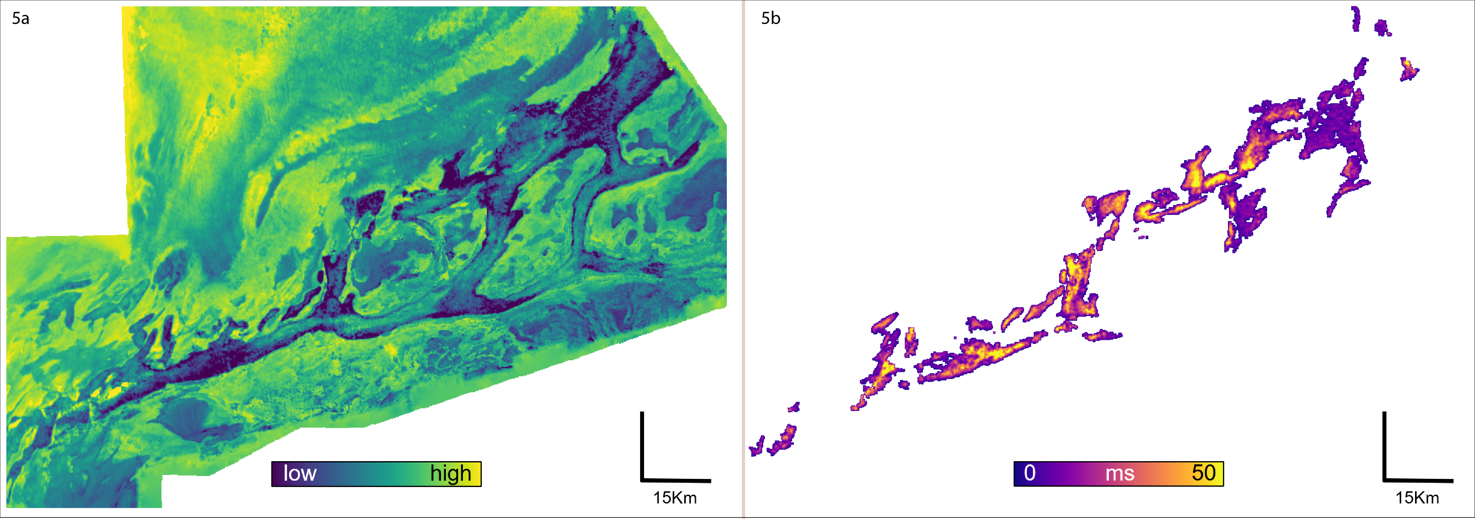
We then further high-graded the fluid indicator attribute using a selection criterion in the fluid indicator/S impedance space and picked geobodies from the result. By mapping out the geobodies, we can visualize areas where the seismic data indicate potential sweet spots for hydrocarbon prospectivity (Figure 5b). The geobodies vary in extent, reaching up to 90 ms two-way time in thickness; when coupled with their positions within the channel systems, some will be more attractive or plausible than others. By linking this information with our understanding of the lithology, paleogeography, and geological timeline, we can determine which of these areas are likely to have reservoir potential.
Foundation for informed action
Our AVO screening indicated several potential hydrocarbon leads within the Paleocene hybrid channel systems seen in this seismic volume. These channels are observed to exhibit Class II/III AVO. The fluid indicator attribute allowed us to identify areas with potential fluid effects and, when combined with S impedance, isolate and capture the most anomalous features. The integrated methodology successfully demonstrates how advanced seismic attributes can help unlock prospectivity in frontier basins.


