
Understanding the structural evolution of the Norwegian Sea
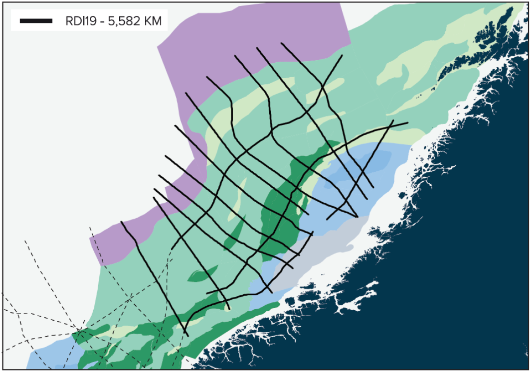
Every continental margin deserves a consistent, regional 2D seismic dataset, which images the mega-structures, including the Moho. MCG’s Regional Deep Imaging (RDI) MC2D project is just the data needed for this task. With recording lengths down to 16s TWT and meticulously geologically designed survey profiles, a full view of the mega-structures can be mapped. In this article, we will focus on the RDI19 dataset in the Norwegian Sea.
The RDI19 dataset
The RDI19 data was acquired with Rosgeo’s Akademik Lazarev in the late summer of 2019. To image the very deep structures, such as the Moho, MCG applied a large source of 6,270 in3 and a 12,000m-long streamer. The first part of the streamer was towed slanted from 15m to 30m, while the last part was towed flat at a depth of 30m. This was done to acquire high frequencies in the front and weaker signals from the Moho in the deep part of the streamer. Data was recorded in continuous mode with a record length of 16s TWT. The data was processed by DUG in London using the newest deblending and deghosting techniques. Processing was completed in June 2020.
The Norwegian extensional system
The Mid-Norwegian Møre and Vøring rifted margins record a tectono-sedimentary history that is exceptionally long, spanning more than 400 million years. It can be summarised in three major geological stages, including an orogeny, its gravitational collapse and a successful rifting that led to the establishment of the northern segments of the North Atlantic oceanic ridge system. The geodynamic evolution of the Møre and Vøring margins is obviously polyphase, and the interpretation of the offshore imaged geometries is not straightforward. The basement and sedimentary structures have been shaped by various geological processes, including brittle and ductile deformation modes, magmatism and metamorphism of various degrees, sedimentation in both shallow nearshore and deep offshore contexts, particular uplift and subsidence histories. Geometries are complex and misunderstanding of the accurate architecture and evolution is easy when studied on a standard dataset. The analysis, interpretation and modelling of this unique rift system therefore requires a specific first-class dataset.
As introduced above, the geodynamic evolution of the Møre and Vøring margins is polyphase: the pre-Mesozoic rift setting is structurally extremely heterogeneous, including inheritance from the previous orogenic and collapse tectonic phases (e.g. Bartholomew et al., 1993; Faleide et al., 2010). It was early assumed that the offshore Mid-Norwegian area, which previously corresponded to the Caledonian orogeny, encompasses significant remnants of structures related to the orogenic collapse, such as shear zones, basement fault systems, and paleo-highs, which controlled, or at least influenced, the subsequent development of the rift basins (Fossen et al., 2016). The correct identification and mapping of these structures is thus fundamental to a proper understanding of the tectono-sedimentary evolution of the rift basins lying above.
From Mesozoic times, rifting in the Norwegian Sea is presumed to have evolved in a ‘classical’ way with a succession of distinct deformation phases, as often assumed in conceptual models (e.g. Peron-Pinvidic and Osmundsen, 2018). These are:
- A stretching deformation mode that formed a new series of high angle normal faults, cutting or reusing the former ‘collapse’ detachment faults (depending on activation/reactivation structural context);
- The necking operated by a combination of brittle and ductile deformation, similar to the collapse deformation mode, although in a more local context;
- Once the crust was sufficiently thinned, the rift system passed the ‘coupling point’ and entered the hyperextension/exhumation mode and ultimately the break-up mode.
These distinct deformation phases affected the extensional system successively, each involving specific tectonic structures leading to distinct sedimentary record contexts. Geometries issued from previous rift stages can additionally be reused, reactivated, deactivated and/or cannibalised by the subsequent deformation phases giving rise to complex architectures (e.g. Naliboff et al., 2017). Within that context, the quality, resolution, and coverage the RDI19 dataset made available to the study is crucial.
Unprecedented possibilities
The RDI19 dataset allows for an unprecedented imaging of the Mid-Norwegian margins. Not only does it provide an excellent imaging of the major sedimentary and basement structures of the Møre and Vøring margins, it also gives access to unique information about the overall basement thinning evolution, sedimentary record, and uplift-subsidence history at margin scale.
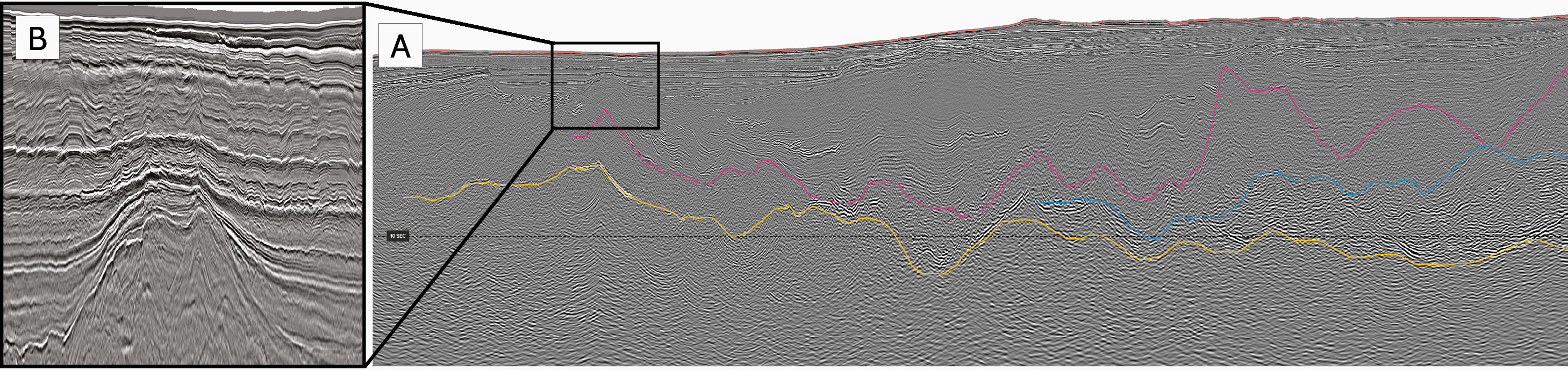
The major strength of the RDI19 dataset is that it, for the first time, images the entire crustal section of the rifted margins at a regional scale. To perform a robust and accurate study and mapping of a rift system, the interpretation must include the first order interfaces: the seafloor, the acoustic top-basement and the Moho. These interfaces are the fundamental envelopes delineating the core architecture of every rifted system. They enable us to determine and quantify key parameters such as the amount of basement thinning, accommodation space and subsidence, sedimentary and magmatic input, and newly accreted basement. All these parameters are of crucial importance for any mapping and modelling purpose. Even though the focus area for some projects can be extremely local and at smaller scale (e.g. reservoir), the correct calibration of the study within the regional structural framework is fundamental. It will also help to avoid any misinterpretation and misunderstanding of the mapped geometries.
Modern seismic reflection datasets, acquired during the last two decades, have enabled us to identify and map some of these main basement geometries. The RDI19 dataset now allows for a correct and robust calibration of these geometries by including a proper structural mapping of the entire basement, including the deepest geometries (crust and mantle) and the Moho. The RDI19 is the first dataset providing clear imaging of the Moho interface at margin scale. The high quality seismic profiles image the Møre and Vøring margins in dip and strike directions and allow for robust and accurate mapping and studying of the base of the crust, from the proximal to the most distal settings, revealing unprecedented geometries. The underlying mantle is also clearly imaged and can be investigated. Dip and along-strike facies variations, together with internal structures are identified, pointing to a tectonic history that is not yet constrained.
The RDI project may look academic at first glance, but the mapping of deeper geological layers and rocks, understanding the temperatures and heat flow, mapping the regional deep faults and correlating the sedimentary mega-sequences have a serious impact on play and prospect analyses.
References
- Bartholomew, I.D., Peters, J.M., Powell, C.M., 1993. Regional structural evolution of the North Sea: oblique slip and the reactivation of basement lineaments, in: Parker, J.R. (Ed.), Petroleum Geology of Northwest Europe: Proceedings of the 4th Conference. Geological Society, London, pp. 1109-1122.
- Faleide, J.I., Bjørlykke, K., Gabrielsen, R.H., 2010. Geology of the Norwegian Continental Shelf, in: Bjørlykke, K. (Ed.), Petroleum Geoscience: From Sedimentary Environments to Rock Physics, pp. 467-499.
- Fossen, H., Khani, H.F., Faleide, J.I., Ksienzyk, A.K., Dunlap, W.J., 2016. Post-Caledonian extension in the West Norway–northern North Sea region: the role of structural inheritance. Geological Society, London, Special Publications 439.
- Naliboff, J.B., Buiter, S.J.H., Péron-Pinvidic, G., Osmundsen, P.T., Tetreault, J., 2017. Complex fault interaction controls continental rifting. Nature Communications 8, 1179.
- Peron-Pinvidic, G., Osmundsen, P.T., 2018. The Mid Norwegian – NE Greenland conjugate margins: Rifting evolution, margin segmentation, and breakup. Marine and Petroleum Geology 98, 162-184.


