The hydrocarbon potential of the East African Rift System (EARS) has been known for years, with discoveries dating back to the early 1920s. Countries like Sudan, Uganda, Tanzania and Kenya have been proved to contain considerable quantities of oil and gas, but further south, where the rift passes through Malawi, exploration has barely started. Much of the country, and the Lake Malawi Basin in particular, is believed to possess promising geology and has indications of petroleum systems.
Rifting Dominates
As with much of East Africa, the geology of Malawi is dominated by the ongoing splitting of the African plate, which has resulted in the EARS. This stretches more than 4,000 km from Eritrea and Ethiopia in the north, where rifting initiated about 40–50 million years ago (Ma), southwards to Malawi where rifting may have commenced as recently as 8 Ma, and on into Mozambique. The system comprises two arms; the older eastern branch through Kenya is more volcanically active than the younger western branch, which contains some of the world’s oldest and deepest lakes, including Lakes Tanganyika and Malawi.
The majority of the country is dominated by crystalline metamorphic and igneous basement rocks which have been subjected to several periods of deformation, primarily during the Precambrian. In the Permo-Triassic, the continental extension splitting the supercontinent Gondwana apart led to extensive faulting, resulting in the formation of long narrow north-east to south-west trending troughs in which sandstones, limestones and mudstones of the Karoo Supergroup were deposited. These sediments were subjected to repeated periods of uplift, erosion and faulting from the Jurassic to the present, producing graben structures in which Tertiary and younger sediments were deposited. Quaternary lacustrine sands and gravels are common in the Lake Malawi area, indicating the retreat of the lake to its present position.
There are some Jurassic-aged basalts in the far north and south of the country and several carbonatite intrusions in southern and south-central Malawi. Unlike the older rift system, however, there is little evidence of magmatic activity and volcanism associated with rift formation, with the exception of some Pleistocene volcanics found near the northern end of Lake Malawi. There are also hot springs in the western and southern lake area.
About 75% of Malawi’s land surface is a gently undulating plateau lying between 750m and 1,350m, with mountains over 2,500m in the north and south. Lake Malawi comprises 20% of the county’s total surface area.
Evidence of Hydrocarbons
Unlike much of East Africa, oil exploration did not commence in Malawi until the 1980s, when ten international oil companies sponsored Duke University to conduct a seismic survey over Lake Malawi. Lying as it does in the EARS, bounded on either side by major faults, and the recipient of deltaic sediment input from a number of rivers over millennia, the lake has long been considered the most likely place to find hydrocarbons in Malawi. Although a very broad-brush approach, this survey did indicate that there were thick sedimentary units, in places exceeding 4,000m, and also identified large structural features, suggesting the potential for Tertiary hydrocarbon systems similar to those found in the Albertine Graben, where ten discoveries have been made since 2006. The water depths where the greatest thicknesses of sediments were located made exploration uneconomical at the time. Further UN-funded airborne geophysical surveys noted the presence of thick sedimentary rock formations under Lake Malawi, in the Lower Shire Valley in the south and the northern Vwaza Marshes area.
Oil seeps have been observed in Lake Malawi and its vicinity for years, indicating the possibility of mature source rock deposition at depth. The seeps may be the result of the anoxic conditions which have been part of the development of the lake since the Tertiary, but could also be linked to the older Karoo sediments common in the southern part of the EARS, which are coal-bearing elsewhere in southern Africa. Studies by Kagya et al. (1991) suggest that kerogens found in Early Permian Karoo coals and carbonaceous shales in the Lake Malawi area could be good sources for gas/condensate or light oils. The source rock kitchen is expected to be in the deeper part of the half graben. Through sequence stratigraphy (Saunders), it has been shown that there have been many oscillations in the lake level linked to climate variations, and that peak source rock deposition may be linked to lake highstands and reservoir formation to lake lowstands.
The evolution of the rift basin itself provides a trapping mechanism for migrating hydrocarbons, not just in the Lake Malawi area but also further south in the valley of the Shire River, the only outlet of the lake.
State of Exploration
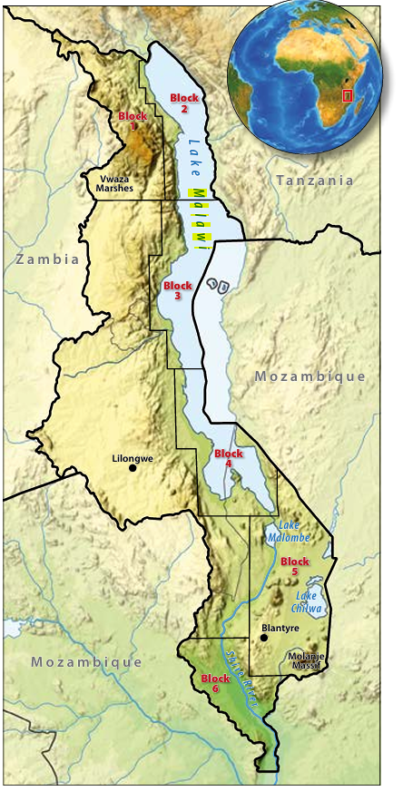
In 2011 the government offered six blocks for hydrocarbon exploration. Block 1, covering the Vwaza Marshes/Chitipa area in the north-west, is considered to have potential, as it contains a number of fault-bounded basins filled with Karoo sediments, overlain by Tertiary sediments. South African independent Sac Holdings have held the area since 2012 and have undertaken regional geological, geophysical and satellite screening studies, as well as environmental and social risk screening. After positive results from these, they are now planning a geochemical study and passive seismic tomography. The block encompasses environmentally sensitive areas both inside and outside national parks.
Lake Malawi is divided into three blocks roughly coincident with the basin structure. Block 2, Lake Malawi North, encompasses the North Basin, which is a single half-graben with the primary border-fault margin running along the eastern side of the lake. A zone of north–south trending faults downthrown to the west lies in the centre of the lake here. The Central Basin, covered by Block 3, extends about 150 km and is bound on the west by a border fault system downthrown to the east. In the middle of the block a north-west dipping fault zone striking south-west to north-east cuts through the southern edge of the basin, displacing the water bottom by about 75m. Blocks 2 and 3 were awarded to Surestream Petroleum in 2011, who undertook environmental and social impact studies before selling the acreage to UAE-based Hamra Oil in 2013. It undertook airborne gravity, magnetic and full tensor gravity surveys and claims that the results indicate potential hydrocarbon accumulations, particularly in the deepest areas of the lake. The company is reportedly planning further investigations, possibly including 2D seismic and onshore drilling using environmentally friendly techniques.
Block 4, Lake Malawi South, encompasses the largest and shallowest part of Lake Malawi, the South Basin, where water depths of about 400m are found near the primary borderfault on the eastern edge of the lake. Another UAE company, RAK Gas, holds this acreage and the adjacent onshore Block 5 in the Lake Chilwa/Lake Malombe area to the south and has completed full tensor gravity surveys as well as environmental impact assessments over the two blocks. There are plans for more detailed geological mapping in parts of the acreage. Block 5 is believed to hold good thicknesses of sedimentary rocks.
Ghana-based Pacific Oil and Gas has also conducted airborne geophysical surveys across its Block 6 Lower Shire rift acreage in the very south of the country.
The Malawi government recently launched a project to geologically map the whole country, last done in the 1960s. Funded by France, Finland and South Africa, the project will commence with a countrywide aeromagnetic survey and will have a particular emphasis on mineral potential.
Issues to Solve
Although still in its infancy, hydrocarbon exploration in Malawi is already controversial. Licence allocation and alleged secrecy surrounding the process raised concerns that the original contracts had serious shortcomings. Exploration by RAK Gas and Hamra was briefly suspended in 2014 while legal investigations were ongoing and there have been some renegotiations, with moves to increase government take. The government is also undertaking a review of the Petroleum Act to tighten licences and regulations.
The greatest chance of hydrocarbon discoveries is in and around Lake Malawi, which is bordered to the north and north-east by Tanzania. There is a decades-long dispute over this area, as Tanzania claims half the lake – which it calls Lake Nyasa – while Malawi draws the boundary at the east coast. In May, Malawi threatened to take Tanzania to the International Court of Justice over the issue and negotiations are ongoing. Neither Mozambique, which owns the east-central part of the lake, nor Tanzania are encouraging exploration in the area at the moment, because exploration and discoveries elsewhere in their countries are taking priority. Heritage Oil has undertaken gravity and geochemical surveys on its Tanzanian Kyela block at the northern end of the lake and reported the presence of tilted fault blocks and structural features, reinforcing the prospectivity of the area.
Environmental Concerns
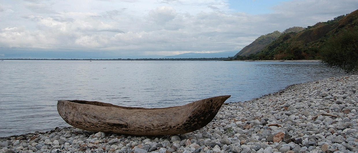
The prospect of drilling in Lake Malawi raises a number of environmental and ecological concerns which must also be taken into consideration. The third largest lake on the African continent, it is hugely important in the local economy; over a million Malawians rely on it for water, electricity, irrigation, and most importantly, fish. The lake is thought to be home to more tropical fish species than found in any other freshwater body on Earth, including over 1,000 species of colourful cichlids, of which at least 395 are endemic. Scholtz et al. (2001) found that water levels in Lake Malawi have ebbed and flowed many times over the past million years, sometimes by as much as 200m, which is thought to explain this diversity. The lake gives a unique record of climatic, evolutionary and tectonic change in tropical east Africa, and some believe it is as important in evolutionary studies as the Galapagos Islands. In recognition of the unique nature of this lake, the Lake Malawi National Park at its southern end was designated a UNESCO World Heritage site in 1984.
It is clear to see, therefore, that the prospect of drilling for, and producing hydrocarbons from such a unique and fragile ecosystem will be fraught with environmental concerns for many people. The government has countered these by pointing out that they have an overall structure in place to ensure sustainable development and also insist that only onshore drilling using modern technology will be allowed in the lake area.
Managing Expectations
Malawi is one of the world’s most densely populated and least developed countries; more than three-quarters of the population depend on agriculture, which accounts for about one-third of GDP and 80% of export revenues, the majority being tobacco. Most of the population use wood as their domestic fuel, which, coupled with deforestation for tobacco plantations, is environmentally unsustainable.
It is understandable therefore, that Malawians are looking at the possible wealth in their rocks, and in particular at the definite potential for discovering oil and gas. Licences to explore for hydrocarbons include local content policies to ensure local opportunities and jobs, and discussions have been held with local stakeholders, increasing expectations in those regions. However, it is early days in the exploration process and these expectations should be tempered by the reality of the time scale and economics involved in exploring and developing a discovery; the many calls on oil companies’ limited exploration budgets in the present price situation; and the issues involved in exporting from landlocked Malawi to markets a long way away.
Acknowledgement
Many thanks to Hilton Banda, Akatswiri Mineral Resources, for assistance with this article.
Further Reading
Western Tanzania: The Lake Rukwa and Lake Nyasa Rifts by Will Thornton
Independent explorer Heritage Oil focuses on regions which may have been overlooked and where it can participate as an early entrant. We look at its exploration efforts in two blocks in Tanzania, considered analogous with the Lake Albert Basin in Uganda. This article appeared in Vol. 11, No. 5
Oil and Gas Exploration in East Africa: A Brief History by Peter Purcell, P&R Geological Consultants Pty Ltd.
East Africa is the emerging hydrocarbon province of the 21st Century – but it is worth remembering that this success comes after six decades of unsuccessful exploration. This article appeared in September, 2014
The East African Rift System – A View from Space by Michael Hall and John Diggens; Astrium Geo-Information Services
Remote sensing data has given a unique perspective on the East African Rift System, allowing both large regional structures and more subtle features to be identified and placed in context This article appeared in Vol. 8, No. 4
References
Carter, G. S and Bennet, J. D. (1973). The Geology and Mineral Resources of Malawi. Bulletin Geological Survey Malawi, 6.
Lyons, R, Scholz, C. A., Buoniconti, M. and Martin, Matthew. (2011). Late Quaternary stratigraphic analysis of the Lake Malawi Rift, East Africa: An integration of drill-core and seismic-reflection data. Palaeogeography, Palaeoclimatology, Palaeoecology. 303. 20-37. 10.1016/j.palaeo.2009.04.014.
Ray, G.E (1974). The Structural and metamorphic geology of northern Malawi. Journal of the Geological Society, 130, 427-440.
Ray, G.E. (1975). The Geology of the Chitipa-Karonga Area. Bulletin Geological Survey, Mw. 42.
Saunders, C.C., Petroleum Systems in East African Rift Lakes: Past and Present
Scholz, C. A and McCartney, T. (2016). 1.3 million year record of synchronous faulting in the hangingwall and border fault of a half-graben in the Malawi (Nyasa) Rift. Original Research Article. Journal of Structural Geology, Volume 91,
Scientific drilling in the Great Rift Valley: The 2005 Lake Malawi Scientific Drilling Project — An overview of the past 145,000 years of climate variability in Southern Hemisphere East Africa – Scientific Figure on ResearchGate. Available from: https://www.researchgate.net/251491837_fig2_Fig-2-Bedrock-geology-and-fault-map-of-the-Lake-Malawi-Rift-from-Lyons-2009 [accessed 17 Sep, 2017]
https://www.researchgate.net/publication/260438305_Basement_and_alluvial_aquifers_of_Malawi_An_overview_of_groundwater_quality_and_policies [accessed Sep 13, 2017].


