Helping non-geologists gain a better understanding of reservoir geology by exposing them to outcrops, in multidisciplinary teams, with geological guides on hand
Understanding the geology of a potential or producing field is a key component in calculating its potential volumes, and in planning its successful development. Yet it is often difficult for the geologists in integrated teams to explain concepts such as the interpreted depositional setting in which the reservoir formed, inter-well correlation, sand body connectivity and reservoir heterogeneities to their colleagues, or how these will affect the production of the resource. One of the biggest challenges is trying to get an appreciation of the scale of the reservoir and its component elements such as sand bodies and fractures. How can non-geologists such as geophysicists, reservoir engineers, petrophysicists and petroleum engineers really get to grips with the rocks?
A G4NG field trip looking at limestone outcrops in the Rockies, close to Exshaw, Alberta, Canada, which will help appreciate reservoir scale. (Source: Jon Noad)
Sedimentary, My Dear Watson
All is not lost. One of the most enjoyable aspects of geology is its accessibility to the layman, primarily because it is based on careful observation and interpretation, rather than complicated equations. Geology is full of ‘wow moments’, with dinosaurs, mammoths, volcanoes, earthquakes and tsunamis giving it an almost lurid appeal.
An avocado demonstrating the Earth’s internal structure. Image by TheCozyCoffee.
However, many of the aspects of sedimentary geology are far more mundane, such as looking at rivers and shallow seas, and the deposits that they generate. They are also readily available to view in outcrops all over the world. Elements such as sedimentary structures and trace fossils, once explained, are easily comprehended.
Over the last 20 years I have set up several ‘Geology for Non-Geologists’ (G4NG) courses for various oil companies, in diverse locations and spanning four continents. Ideally the course is divided up into a single day in the classroom followed by two days spent in the field. Everyone recognises that there is a lot to learn, and rather than wallow in the complexities of sedimentary structures and strain ellipses, the classroom lectures are kept short and entertaining. They are interspersed with practical exercises designed to teach geological concepts through the application of simple principles.
A good example is a short lecture that uses food to explain concepts such as folding and fracturing, by gradually bending cheddar cheese until it cracks. An avocado can be used to show the Earth’s crust and mantle, and we ask the students to use sliced bread to create geological cross-sections. Another exercise has them designing organisms to live in different settings, and then imagining what sort of structures they would create as they burrow through the sediment. Geological themes covered include sedimentology, palaeontology, structural geology, oil genesis and migration, exploration and production, and basin evolution, all attacked from novel perspectives.
Dinosaur footprints, forming part of an exercise during a G4NG field trip, Purbeck Limestone, Isle of Portland, Dorset.
Location, Location, Location
Of course, the key learnings take place on the rocks. When selecting the field location, ideally the outcrops should offer the widest possible range of depositional settings within a relatively small area, in order to minimise driving time. In addition, the presence of a working petroleum system in the area adds an extra element of relevance to the fieldwork. Dorset in southern England has proved to be an outstanding location for a G4NG course: an area of natural beauty and a World Heritage Site, with a wide variety of sedimentary rocks exposed along the coast, in addition to oil production.
A G4NG group on the outcrop at Freshwater Bay, on the Isle of Portland Portland, Dorset. (Source: Jon Noad)
Oil is being produced from both the Kimmeridge and Wytch Farm oil fields, the latter being Britain’s largest onshore oil field with a STOIIP of some 900 MMbo. The main reservoir rocks, the Sherwood Sandstone and Bridport Sands, are exposed at Ladram Bay and Bridport respectively, and a world-class seal and source rock outcrop at Kimmeridge Bay (below). Another source rock at Lyme Regis is chock-a-block with giant ammonites. Depositional settings range from rivers to deserts, alluvial fans, lagoons, beaches and shallow seas. The same structures that trap oil at Wytch Farm are strikingly exposed at Lulworth Cove, where a huge fault drags the sedimentary rocks until they dip near vertically. There is even an oil seep on the beach at Osmington!
Another classic location for a G4NG field trip is around Canmore and Banff, in the Canadian Rocky Mountains of Alberta. Also a World Heritage Site, the region offers a breath-taking backdrop. A field trip run over one day includes two clastic outcrops, one exposing shallow marine mudstones and sandstone beds with some striking trace fossils. The second has a continuous succession shallowing up from turbidite deposits, through shoreface sandstone beds with fossilised tree trunks, and up into fluvial channel deposits. The attendees walk it out, imagining that they are swimming up the palaeoslope and clambering onto the beach.
There are also two limestone outcrops, which provide the chance to talk about depositional cycles and sea level change. Bedding planes expose several fracture sets, which are utilised in a fascinating exercise on producibility. An ash bed, deposited in the same eruption that created Mono Lake, leads to a lesson on catastrophic events, and there is an obligatory structural stop to look at thrusts, illustrated with a folded field guide. As in Dorset, there is a working petroleum system in the vicinity to provide a strong link to the hydrocarbon industry.
The world-class seal and source rock outcrop at Kimmeridge Bay, Dorset, UK. (Source: Jane Whaley)
Nodding donkey producing oil at Kimmeridge Bay, Dorset, UK.
G4NG participants working on the logging exercise in Bowes Quarry, Isle of Portland, Dorset. (Source: Jon Noad)
G4NG participants examining stacked, Triassic, reservoir sandstone beds at Ladram Bay, Dorset. (Source: Jon Noad)
The ammonite graveyard at Lyme Regis, Dorset, visited during the G4NG field trip. (Source: Jon Noad)
Getting Back to the Rocks
Fossil tree trunk exposed in the Jurassic Fernie Formation at the Banff Traffic Circle, Alberta. (Source: Jon Noad)
In terms of overall logistics, a safety briefing and short introductory lecture set the scene the evening before the field trip begins, and multi-disciplinary teams of four are assigned. Everyone gets a field guide, packed with information and diagrams, as well as a basic geological glossary, because geologists have an inordinate fondness for acronyms and obscure terminology. For example, one man’s sea level rise is a geologist’s transgression.
The following morning we head into the field. I like to start each outcrop with a short story, which helps to embed the basic geology in the participants’ heads. For example, when looking at deep water sedimentary deposits, they learn about the 1929 earthquake in Grand Banks, Newfoundland. This triggered landslides that sent turbidity currents racing downslope at up to 130 km/hour, breaking transatlantic cables in at least 23 places. The resulting tsunami reached Portugal, while the cable breaks allowed scientists to prove the existence of turbidites for the first time. Hopefully the next time someone mentions turbidites in the office, they will think of sediment-laden plumes careering through submarine canyons.
Sketch drawn for the G4NG field trip. showing a series of thrusts exposed around Banff, Alberta. (Source: Jon Noad)
The next thing is to set the participants loose. At every outcrop they are given a simple exercise, usually a combination of observations, followed by interpretations. An example would be to sketch an outcrop and then to try to pick out the different sediment packages. Once completed, they have to pick out the potential reservoirs, and decide how to drill them. Each exercise is carefully designed to build upon the ones preceding it, developing the confidence of the students by not introducing too many new concepts in too short a space of time. Two field trip leaders, both experienced geologists, move between the teams to help them whenever necessary.
After completing an exercise, a team will be chosen at random (to keep them all on their toes) to present their findings, which leads to a facilitated discussion. There are no wrong answers. The field trip leader will draw their attention to some of the aspects that help to determine the answer to each exercise. Any specialists on the trip may be asked to contribute, for example the geophysicist may be asked whether a particular bed or structure would be visible on a seismic line. A white board is an invaluable aid for everything from explanations of depositional settings and structures to sketching what the participants should be focusing on.
A highlight of every G4NG field trip is when the non-geologists get to log a short (5- to 10-metre) section of outcrop. Each section has been carefully selected to expose a variety of facies and sedimentary structures, and hopefully a small fault or two. Another unforgettable activity is on the second evening, before dinner. Each team is assigned a fun topic, such as using trace fossils, designed to make them pull together observations from more than one outcrop seen during the field trip. They then put together a ten-minute presentation, delivered to all the attendees, without recourse to slides, often in a convivial setting in the hotel. It is incredible to watch how far they have come in three short days, and the geological discussion continues over dinner.
Getting close to the rocks. (Source: Jon Noad)
A G4NG group on the outcrop near Banff, Alberta. (Source: Jon Noad)
The Gift That Keeps on Giving
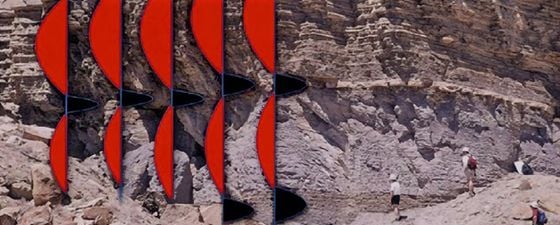
Outcrop of parasequences at Woodside Canyon in Utah, overlain with seismic wiggles.
While it is obviously not possible to ‘create’ a geologist from an engineer over the course of a few days, the G4NG courses provide an awareness of basic geological concepts that can then be directly applied back in the workplace, while ensuring that geologists and their counterparts are now ‘speaking the same language’.
Choosing the right field localities ensures that there are plenty of highlights to keep the newly acquired skills fresh, while an email, sent to the participants as an aide memoire shortly after the field trip, details everything they have learned in 15 concise bullet points. Successful exploration and production rely on working efficiently in integrated teams.
The best way to build cooperation and understanding is by learning from one another and sharing ideas. What better place to do that than on a stunning outcrop in the sunshine?


