It’s now well known that the North Sea was an area of exposed land during the Last Glacial Maximum, around 25,000 years ago, when Global Mean Sea Level was much lower. The landscape was exposed to the elements, particularly ice and wind. But the landscapes now submerged under the North Sea remained poorly imaged and difficult to constrain since the early days of marine geological exploration.
Recently, new, high-resolution geophysical and geotechnical datasets, acquired for offshore wind farm site investigation, have given an unprecedented insight into how these landscapes evolved in response to the changing climate.
A shallow area in the middle of the North Sea
Dogger Bank, in the centre of the Southern North Sea, is an area of shallow bathymetry, making it perfect for developing offshore wind farms. High-resolution shallow seismic reflection data and geotechnical boreholes and Cone Penetration Tests were acquired by the Forewind consortium between 2010 and 2012. These integrated datasets are used to asset ground conditions and suitability for siting wind turbine foundations.

The dataset was also made available to me as part of my PhD research at the University of Leeds to constrain how the landscapes archived within the near subsurface and their geomorphology and sedimentary environments evolved over decadal to millennial timescales.
A network of glacial landforms
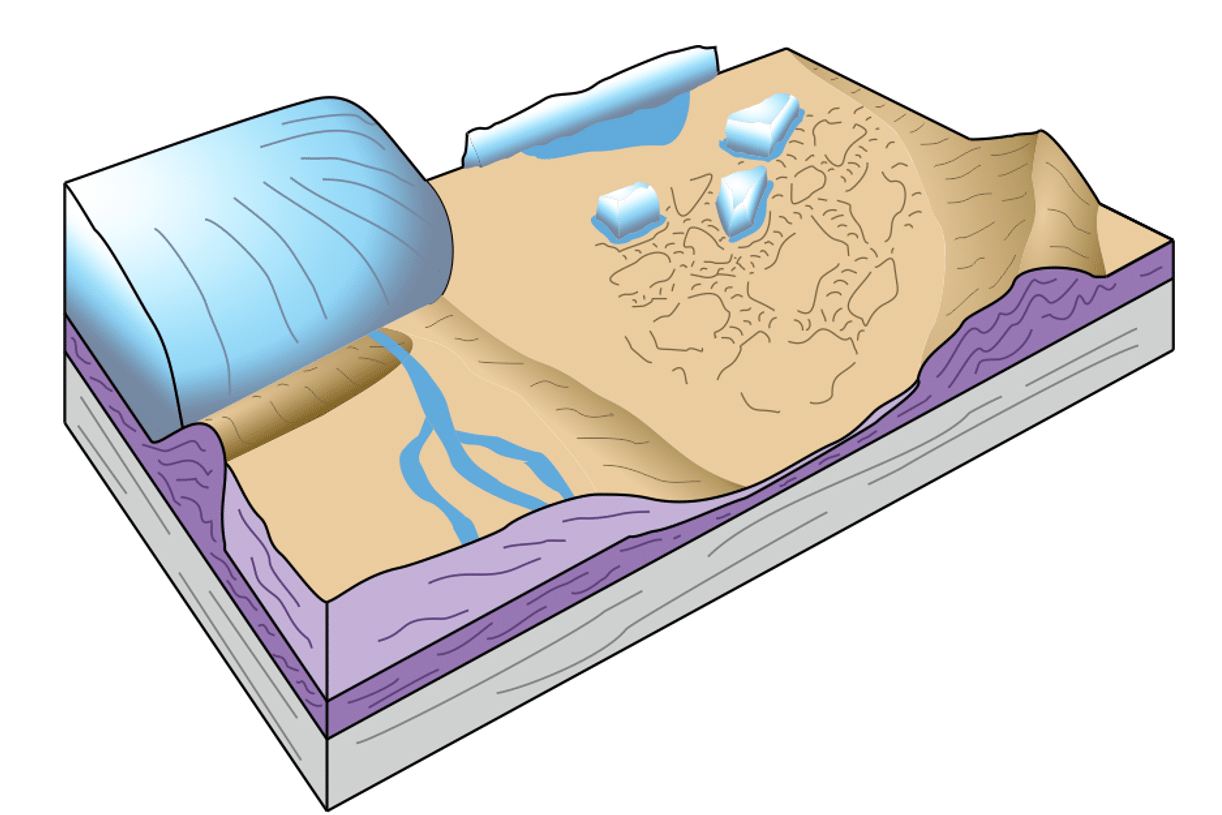
The starting point for this geological story is determined by the depth of investigation necessary for designing wind turbine foundations, which is between 40 to 50 m below seabed. At this depth, most of the geology encountered is interglacial marine deposits from the Last Interglacial, around 120,000 years ago. After this, a large ice sheet built up over Ireland, Great Britain, and Scandinavia, which flowed out into the North Sea. The margins of this ice sheet were very dynamic, advancing and retreating, and formed complex glaciotectonic units associated with landforms such as thrust-block moraines, and evidence of fast-flowing ice streams preserved in landforms such as subglacially-streamlined bedforms. These moraines consist of reworked interglacial marine deposits, mostly comprising shelly clays with some sand and gravel.
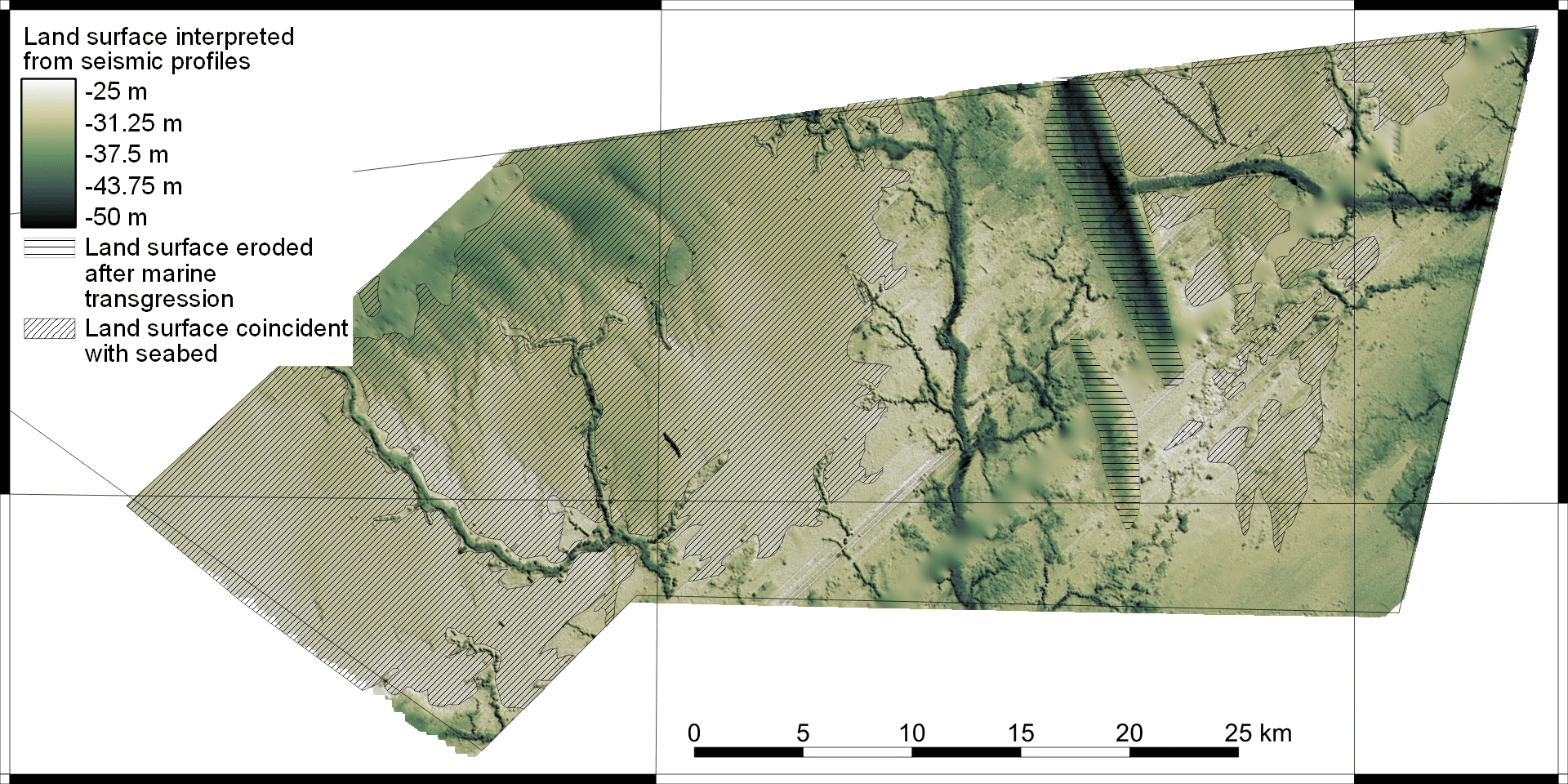
Rivers switching off
As the ice sheet began to retreat from Dogger Bank, around 25,000 years ago, the moraine ridges became basins in which outwash sediments could accumulate. A large proglacial lake formed, roughly twice the size of Lough Neagh in Northern Ireland, that gradually filled with laminated clays and silts supplied by the ice sheet. On the land surface, a complex of proglacial rivers formed. As the ice margin retreated down off Dogger Bank, these rivers were effectively switched off as meltwater rerouted elsewhere to the north of Dogger Bank. Only with increasing precipitation as the climate warmed did the rivers switch back on, with an extensive drainage network forming.

Rapid sea-level rise
As the ice sheets waned globally after the Last Glacial Maximum, Global Mean Sea Level began to rise and rapidly approached Dogger Bank. Like many modern coastlines of the North Sea today, a barrier system formed on the margin of the Dogger Bank island. This barrier retreated as sea levels rose relatively steadily at around 10 mm/yr, but the mode of retreat varied between discontinuous overstepping at first, to a continuous overstepping later. This retreat mechanism was controlled by the pre-existing topography under the barrier, formed by the ice sheet many thousands of years earlier.
Benefits to wind turbine installation
The detailed understanding of the processes that formed the ever-evolving landscape at Dogger Bank, which came from rigorous seismic interpretation and sediment logging, is now being put to use to improve ground models. These models are used to constrain ground conditions, and help with wind turbine siting. By knowing the properties of sediments in the subsurface, individual turbine foundations can be designed specifically, reducing overall costs. The economic benefits of a detailed subsurface study also extend to installation, operations and maintenance, and decommissioning, avoiding dangerous and time-consuming mistakes such as jack-up punch-through. So, even after it has been submerged by rising sea levels, the past landscapes of Dogger Bank are still vital to today’s engineering challenges.
ANDY EMERY