

Offshore Ivory Coast: reducing exploration risk
In 1996 PGS acquired a 1,600 sq.km 3D survey over blocks CI-104, 515, 115 and 116. This survey has now been through reprocessing using a broadband processing workflow and reinterpreted by PGS. Here we present an introduction to the petroleum geology of Ivory Coast and discuss the results of the interpretation project.
Offshore Ivory Coast is part of the West African Transform Margin (WATM), a large tectonically constrained area bound by a series of major fracture zones formed during the separation of the African and American continents during the late Jurassic to Cretaceous. The margin, which has approximately 2,200 km of coastline, extends from Liberia in the west to the edge of the Niger Delta in the east.
Exploration in Ivory Coast has historically been focused on the central and eastern basins where numerous hydrocarbon discoveries have been made, including a trend of gas discoveries in Upper Cretaceous-age stratigraphic traps (Foxtrot, Panthere and Marlin fields) and oil discoveries in Lower Cretaceous structural traps (Lion, Espoir, Acajou, Baobab and Kossipo fields).
This success has motivated explorers to look further afield, extrapolating known play trends whilst hunting new opportunities. The Morue-1X well (Anadarko and Total) and Saphir-1X well (Total) have proven a working hydrocarbon system in the previously underexplored western portion of the basin, whilst the recent Capitane East-1X (Lukoil) and Paon (Anadarko) discoveries have also proven the prospectivity of Upper Cretaceous oil-bearing stratigraphic plays in the deeper waters.
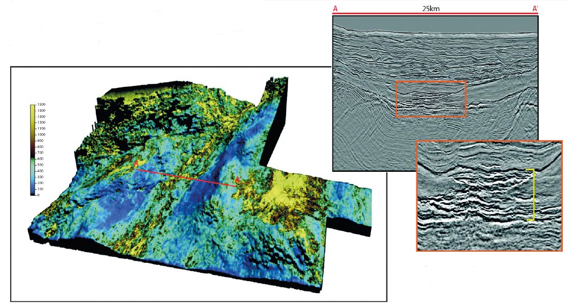
To address this increased exploration activity in the central portion of the offshore Ivory Coast Basin, PGS have been actively acquiring new data whilst also reprocessing the existing library. Part of this reprocessing effort has focused on a 1,600 km2 multiclient 3D seismic survey originally acquired in 1996 using conventional streamers, located in the central part of the Ivory Coast Basin adjacent to recent discoveries.
The survey covers four blocks – CI-104, 515, 115 and 116 – three of which are currently open acreage. By applying a modern broadband time processing workflow (and thus broadening the seismic frequency post-acquisition and trying to remove the source and receiver ghost), PGS have been able to image the deeper syn-transform and early post-transform sections with much greater fidelity. In addition, PGS has two GeoStreamer® 3D datasets, to the west in CI-506 and 507 (currently open acreage), and to the east in CI-12 and 501.
Stratigraphy offshore Ivory Coast
Interpretation work carried out by PGS in the region has identified three distinct tectonic phases, each of which plays an important role in the petroleum system story:
- The syn-rift phase, characterised by pull-apart rifting that formed a horst and graben topography.
- The syn-transform phase, characterised by strike-slip movement that resulted in the inversion of many of the syn-rift structures.
- The post-transform phase, characterised by sediment fill of the post-inversion topography.
The pre-rift stage has not been penetrated by drilling in the central Ivory Coast Basin, although outcrops of rocks of Precambrian to Triassic age do exist east in the Volta and Tano Basins. Pre-rift Jurassic-aged rocks have also been found in the Ivory Coast Basin, which comprise conglomerates and shales deposited in a continental setting.
During the syn-rift stage (Berriasian to Middle Aptian), approximately 5,000m of sediments were deposited in a continental and marginal marine setting in the Ivory Coast Basin (Chierici, 1996), allowing the accumulation of Middle Aptian source rocks. The environment became progressively marine during the Albian as rifting continued, leading to the deposition of sands, shales, calcareous deposits and conglomerates.
The onset of a major phase of inversion occurred during the syn-transform and is marked by a significant unconformity in the Cenomanian that is apparent both in the African and Brazilian margins.
The end of transform movement and inversion was superceded by thermal subsidence in the post-transform stage (Cenomanian–Holocene). This phase almost entirely comprises clastic marine interbeds of varying thickness of sandstones, shales and minor carbonate sediments. Potential reservoir rocks include ponded and channelised turbidite systems and basin floor fans, whilst the organic rich black shales deposited within geographical lows provide potential source rocks.

Petroleum geology
Within the waters offshore Ivory Coast, hydrocarbon discoveries have demonstrated the presence of working petroleum systems within the syn-rift (affected by syn-transform inversion) and post-transform tectonic phases. Future exploration targets can therefore focus on three key plays: Aptian–Albian syn-rift structural plays and early post-transform structural plays, both charged by hydrocarbons from syn-rift lacustrine or shallow marine source rocks, and post-transform channel and fan stratigraphic plays charged by hydrocarbons from a Cenomanian–Turonian source rock.
Successful exploration along the WATM is determined by a number of factors. In the syn-rift, the timing of expulsion related to tectonic phases is an important consideration, whilst in the post-transform, the up-dip pinch-outs of the numerous stacked channels and fans play a key role. The maturity windows of the two source rocks must also be determined to understand the charge of these reservoirs.
New insights from broadband reprocessing
By analysing the amplitude extractions of the broadband reprocessed seismic data, PGS are able to gain effective insight into the distribution and reservoir characteristic of both the post-transform channel systems and the numerous syn-rift structures. This analysis has highlighted a number of untested leads within the region, many with similar characteristics to nearby discoveries.
Further to this, by broadening the seismic frequency post-acquisition and trying to remove the source and receiver ghost during the reprocessing efforts, PGS have been able to improve imaging of the basement nature as well as deeper syn-transform and syn-rift sections. This insight has opened up the potential for new play concepts and the recognition of an untested Jurassic play system within the earliest syn-rift.
This play is modelled to have potential lacustrine source rocks and shallow marine reservoirs.
The future for exploration
Discoveries made by wells such as Saphir-1X, Morue-1X and Capitane East-1X together with the decision by Exxon in 2014 to license new acreage has shown a commitment to continued deepwater exploration in the area where hydrocarbon potential remains.
PGS have a comprehensive, modern-day multi-client seismic data library across the WATM and are actively acquiring new data in both the deepwater and shallow shelf areas to match the exploration requirements of the industry. The data library contains both GeoStreamer acquisition data and conventional acquisition data, much of which has been reprocessed using a broadband workflow.In Ivory Coast the reprocessed data over blocks CI-104, 515, 115 and 116 gives greater insight into the deeper syn-transform sections and greater clarity within the post-transform channel and fan sequences and thus reduces some of the exploration risk.


