The Porcupine Basin
The South Porcupine Basin contains all the elements for a successful petroleum system.
The Porcupine Basin is related to Mesozoic extension across north-west Europe and the break-up of the Pangean supercontinent. It is believed to be a failed rift arm of the proto-North Atlantic, formed within a major wrench-rift zone extending from the Biscay Seaway to Labrador. Triassic through Early Jurassic extension resulted in an approximately north-south rift system extending from the Galicia Bank, offshore Iberia, north into the Porcupine Basin. This extension was followed by a thermal sag phase, with rejuvenated extension in the Mid-Jurassic. Pronounced extension occurred in the Late Jurassic to Early Cretaceous followed by a thermal sag phase in the Cretaceous and Tertiary.
New 3D data and detailed reconnaissance study
The North Porcupine Basin has seen the greater amount of exploration activity, with 28 wells drilled to date. Of these, four have tested hydrocarbons: wells 26/28-1 & 26/28-2 (Connemara oil discovery), well 35/8-1 (Burren oil discovery), and well 35/8-2 (Spanish Point gas-condensate discovery). Many of the reservoirs encountered in the North Porcupine Basin did, however, display low permeability due to diagenesis of the clastic source, derived from erosion of Carboniferous hinterland.
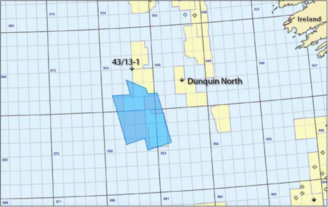
The South Porcupine Basin has a fill of up to 9 km of primarily Mesozoic and Cenozoic age and to date remains virtually unexplored. The two wells drilled in the basin have, however, offered encouragement, with 43/13-1 logging hydrocarbons in Upper Jurassic sands, and 44/23-1 (Dunquin North) encountering a thick Lower Cretaceous over-pressured carbonate reservoir sequence with a residual STOIIP of approximately 600 MMbo.
Tectonic reconstructions suggest the South Porcupine Basin formed a conjugate margin with the Canadian East Orphan Basin. Several discoveries have been made across the conjugate margin, including Mizzen (100–200 MMbo), Bay du Nord (300–600 MMbo) and Harpoon. These discoveries have been made in Mesozoic reservoirs with an Upper Jurassic marine source rock, similar to those proposed for the South Porcupine Basin.
Polarcus, in collaboration with ION Geoventures and GeoPartners Ltd, acquired in 2014 over 4,300 km2 of broadband multi-client 3D seismic data over a number of blocks on the western margin of the South Porcupine Basin. These new data for the first time provide the coverage and resolution needed to evaluate both the structural and stratigraphic plays and also to carry out detailed rock physics studies to evaluate the identified prospects. The new data, as well as covering Providence Resources’ Drombeg exploration prospect, also covers a number of open blocks available for licensing in Ireland’s current 2015 Atlantic Margin Oil and Gas Exploration Licensing Round.
To evaluate the geology and prospectivity of these new data, Lyme Bay Consulting applied their Detailed Reconnaissance Study (DRS) workflow to the post-stack migrated fast-track volume. The DRS builds a ‘GeoModel’ based on the underlying seismic data, and calculates and correlates the relationship between 3D seismic points according to the similarity of the wavelets and their distance from each other. This DRS produces a horizon-consistent map for each and every reflector within the dataset. Attributes are then calculated from the original seismic and overlain on the horizons to deliver a high resolution reconnaissance tool to enable identification of structural and stratigraphic features within the data. Two hundred horizons were generated for this dataset and a number of examples are reproduced herein to illustrate features observed within the data.

Geological overview
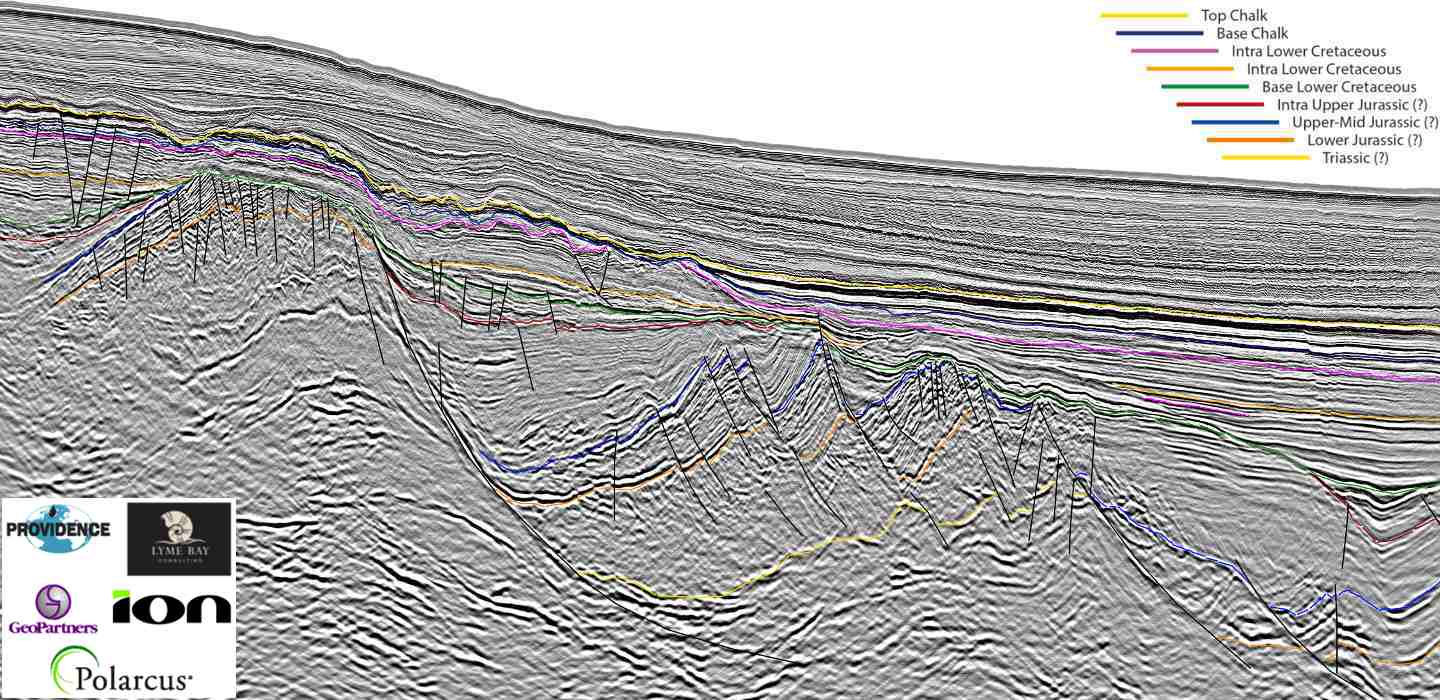
The new data provides a step change improvement in imaging, as seen on the ‘foldout’ line (above), which shows a typical data example from the pre-STM final volume where extensive faulting created during rift development can be observed. A well-developed Triassic to Middle-Upper Jurassic section can be seen within the fault blocks. Much of the Jurassic section in the South Porcupine Basin is believed to be fully marine in nature and, as well as containing potential Kimmeridgian source rocks, reservoir units could also be present within these sequences.
Cessation of rifting was followed by essentially passive infill of the basin, with the Lower Cretaceous sequence overlying and infilling the Jurassic topography followed by deposition of a thick sequence of sediments with varying degrees of clastic input from the basin margins. A Lower Cretaceous source rock within the Barremian to Cenomanian may also be present and thick regional mudstones are believed to form efficient seals across the basin. Numerous stratigraphic features within the Lower Cretaceous sequence reflecting possible shoreface to deepwater clastic systems can be seen, many of which are associated with amplitude anomalies.
The Upper Cretaceous Chalk is widespread across the region and is overlain by a Tertiary sequence, which displays a number of clastic channel and sheet geometries developed within the Paleocene and Eocene.
Lower Cretaceous leads revealed
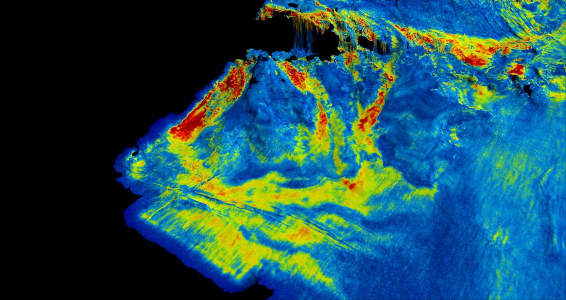
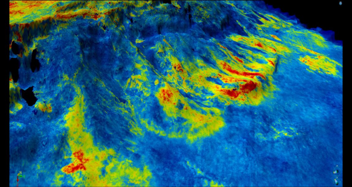
Within the Lower Cretaceous, sediment supply from the western margin of the basin into the deeper marine areas can be seen for the first time in a number of distinct depositional systems. Multiple clastic channel inputs can be observed; the depositional systems display confined geometries across the palaeo-slope areas, which spread into a number of fans in the deeper water areas, often exhibiting distinct lobe geometries. These depositional inputs are long lived and were feeding sediment into the deeper offshore areas throughout subsidence and infill of the basin.
Sediment source for the turbidites was created by uplift and erosion of the Devonian Old Red Sandstone hinterland to the west, suggesting development of better quality reservoir sands than those encountered in the wells in the North Porcupine Basin. The Old Red Sandstone provenance expected in the South Porcupine Basin is a proven model in the adjacent Canadian conjugate margin.
The DRS study has identified several leads, many located in open acreage, which vary from linear channel features to lower energy down-slope fan systems. Amplitude cut-off with depth has also been observed.
A number of structural traps can also be seen to affect the Lower Cretaceous, an example of which is a large detachment feature that has partially detached from the basin margin and has slid into the basin, generating a toethrust with a lateral extent in excess of 25 km along strike. A number of sand units, deposited in canyon-constrained channels or turbidites along the basin margin, can be seen to occur in closures created by folding associated with this toe-thrust development. This is an interesting suite of leads as the collapse back-scar may also provide an up-dip seal to the reservoir-quality high energy depositional systems that will have delivered these sands, thus developing a series of stratigraphic traps with an up-dip structural component.
Promising Conclusions
The South Porcupine Basin 3D data provides new insights into the geology and prospectivity of the western margin of the basin. A well-developed Jurassic sequence, contained within rotated tilted fault blocks, provides potential for both source and reservoir, and several structural and stratigraphic traps can be seen. The overlying Lower Cretaceous contains a number of mapped leads in shelf to basin clastic units which often occur in stratigraphic traps, some with a structural component and some displaying an amplitude cut-off with depth. Potential also exists in Paleocene and Eocene clastic sequences, which are imaged in detail on the new data. The area contains all the elements for a successful petroleum system and the 2015 Atlantic Margin Licence Round provides an exciting opportunity to assess this underexplored and highly prospective area.
Project description
Polarcus acquired this RightBand™ multi-client survey using Polarcus Amani, towing a 10 x 150m x 8,100m ultraquiet Sentinel® solid streamer spread and a 25m alternating shot interval, delivering 81 fold data with a 10 second record length. Data has been processed by ION GX Technology through a state-of-the-art WiBand™ Pre-STM workflow.


