The US Geological Survey just published their first seismic hazard forecast to include both induced (human-caused) and natural earthquakes, identifying populated areas in the centre of the US that could be shaken by induced seismicity.
The US Geological Survey (USGS) has just released the first one-year seismic hazard forecast for 2016 that includes the potential for both induced and natural earthquakes in the Central and Eastern United States (CEUS). These earthquakes potentially create seismic hazard to structures and should be the concern of nearly eight million people living in their vicinity. Past seismic hazard models, including the 2014 United States National Seismic Hazard Model, had nontectonic events, such as those caused by wastewater injection or other human activities, removed from consideration for their hazard assessment. Their objective was to provide forecasts of locations, magnitudes, and rates of future natural earthquakes as well as estimates of long-term shaking hazard that are applied in building codes and other public policy applications. Therefore, induced earthquakes are not considered in the current building-code maps but do create a seismic hazard to structures in a very populated portion of the central US and other areas where they occur.
The hazard maps showing the chance of damage for the western United States and the central and eastern United States (CEUS) for 2016. As can be seen, the chance for damage in north-central Oklahoma and southernmost Kansas is similar to that of high-hazard sites in California. (Source: USGS)
The Need for Assessment
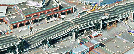
There has been a marked increase in ‘felt’ seismic events in the CEUS since 2009, including a few that have caused considerable damage (see related article, On Shaky Ground, in GEO ExPro Vol. 13, No. 3). A number of scientific studies linked the majority of the increased activity to deep wastewater injection disposal wells. To start the process of assessing and communicating the seismic hazard from induced earthquakes, the USGS held a workshop in Midwest City, Oklahoma in 2014 and over 150 representatives from the government, industry, and academia attended.
The USGS 2016 report, which was guided by discussions from the Midwest City workshop, concluded that, “Assessing hazard and potential damage from these events is difficult because induced earthquakes vary rapidly in time and space based on changes in industrial activity, which can be caused by economic or policy decisions; this variability also makes the induced earthquake hazard difficult to forecast.” Therefore, a forecast would have to address short intervals, such as one year, unlike the past hazard models which applied to a 50-year time period. Short-term forecasts also allow for changes and can be updated as needed.
To develop a one-year hazard model for 2016 that included both induced and natural earthquakes, the USGS built on previous studies. According to Dr. Michael L. Blanpied, Associate Coordinator, USGS Earthquake Hazards Program, “The source model for the new hazard calculations is built strictly from measured seismicity – taking past rates of earthquakes and extrapolating them forward in time through 2016. We did look at other geological data and the locations of oil and gas plays and sedimentary basins, but there was too little publicly available information to construct a uniform model.”
Maps showing peak ground acceleration (PGA) expressed as a fraction of standard gravity (g) for 1% probability of exceedance in 1 year. The 2014 national map (on right) predicts that central Oklahoma is exceedingly unlikely to experience measurable motion (PGA 1% g) whereas the 2016 model predicts that a PGA of 50% g or higher might be experienced. (Note: A PGA level of 1% g is perceptible but unlikely to cause damage while 50% g would likely cause substantial damage to any buildings located near the shaking.) (Source: USGS)
Making a Difference
Oklahoma Governor Mary Fallin said, “The USGS shows why actions taken by the Oklahoma Corporation Commission earlier this month were necessary.” On March 7, the Oklahoma Oil and Gas Conservation Division announced that it is continuing to reduce the amount of wastewater injected by disposal wells into the Arbuckle Formation. This order affects more than 400 disposal wells, reducing the volume of wastewater injected by 40% below the 2014 level, in their effort to curb earthquake activity in central Oklahoma.
Governor Fallin also said, “Recent declines in wastewater disposal in Oklahoma are not reflected in the USGS map. This (the USGS map and report) gives even a stronger base in going forward and gives state regulators further justification for what they are doing.”
The USGS is the only federal agency with the responsibility for recording and reporting earthquake activity nationwide and assessing seismic hazard. Their 2016 report and maps are part of the National Earthquake Hazards Reduction Program which Congress established with the purpose of reducing earthquake risks in the US. Although only out a short while, the report is already making a difference.
More Information
USGS Earthquake Hazards Program – http://earthquake.usgs.gov/hazards//induced/
National Earthquake Hazards Reduction Program – http://www.nehrp.gov/