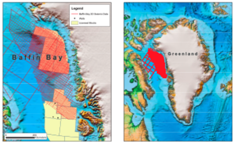
Baffin Bay reprocessed
The majority of exploration focus has historically been in the central area offshore West Greenland, however since 2007 there has been increased interest in the Baffin Bay area. The 2D fold out line on the previous page illustrates the detailed level of interpretation now possible due to advances in processing technology. The new techniques described give the explorationist access to a previously unseen level of detail within the major structural features of the Greenland shelf.
This summary focuses on the emerging petroleum province of the Baffin Bay area of West Greenland. The line shown lies a significant distance from well control (> 200 km) therefore stratigraphic understanding comes from combined sea floor sampling, onshore outcrop and offset wells. The stratigraphic section expected comprises possible Paleozoic pre-rift overlain by multiple phase Cretaceous (?) syn-rift deposition, which in turn is overlain by the post-rift Paleogene and Neogene sequences.
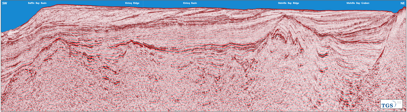
The line is orientated south-west to north-east and has an overall length of 275 km, stretching from the Greenland coast in the north-east, to beyond the modern day shelf break in the south-west.
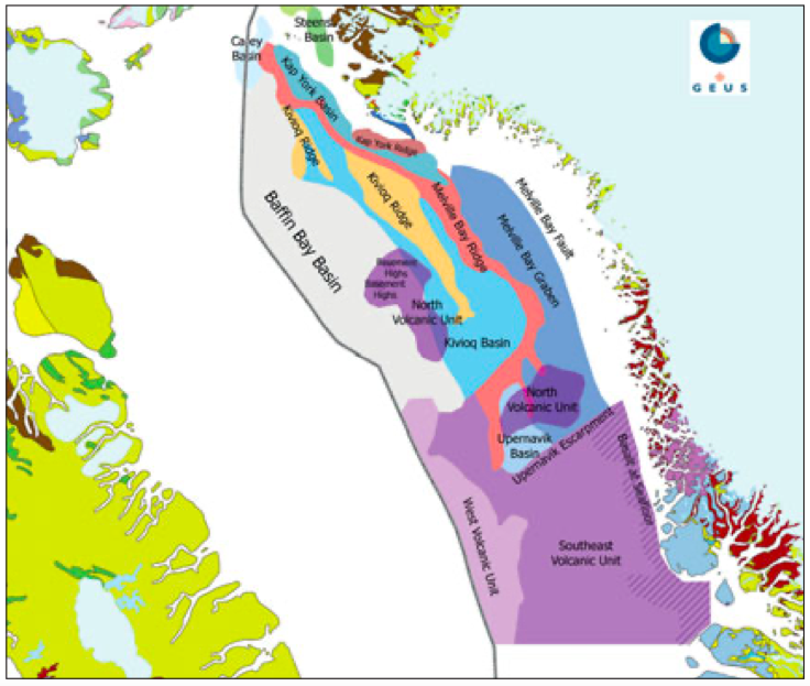
The Melville Bay Graben and Kivioq Basin form the principal tectonic elements located on the shelf. The Melville Bay Graben is the most north-easterly basin on the line, while to the south-west is the Melville Ridge, which separates the Melville Bay Graben from the Kivioq Basin. The Kivioq Basin is approximately similar in dimensions to the Melville Bay Graben, and is intersected by the Kivioq Ridge extending from the north and terminating just south of the line shown. Further to the southwest the line obliquely cuts a high, separating the Kivioq Basin from the Baffin Bay Basin which then extends south-west beyond the shelf break.
Significant potential
The north-north-west to south-southeast orientated Melville Bay Graben is comparable in extent to the Outer Moray Firth or the Central Graben of the North Sea and represents significant exploration potential. It is characterised by multiple phase syn-rift deposition, with sediments believed to consist of Early Cretaceous fluivio-deltaics and marine deposits and late Cretaceous turbidites. The Cretaceous succession is overlain by regional Paleocene mudstones, Palaeogene fans and Neogene mudstones. The new improved processing techniques described below allow more accurate definition of deeper structures and interaction with the stratigraphic basin fill. Fault planes, splays and hanging wall rollovers at 5 – 6 seconds are now more clearly imaged for interpretation.
The Melville Bay Ridge bounds the Graben to the south-west and was uplifted during the early Paleogene. The upper sequence present within the ridge is interpreted to comprise a series of tilted and subsequently uplifted and rotated fault blocks containing Cretaceous age clastics. Moving south-west along the line, the Melville Bay Ridge gives way to the Kivioq Basin. This is cut obliquely by the line and forms another regionally significant tectonic element with considerable exploration potential. The basin is divided by the southern extent of the Kivioq Ridge. To the south of the line the ridge dies out and the north-east and south-west partitions of the basin merge.
In this section the basin appears to have a Cretaceous stratigraphy comparable in thickness to that found in the Melville Bay Graben. The new processing techniques employed in the Baffin Bay 2010 survey more clearly image mid-Cretaceous and deeper levels in the Kivioq Basin. A clear distinction is seen in the deformation style present within the early Cretaceous basin fill, compared to that seen in late Cretaceous levels. The early Cretaceous is characterised by a series of tilted fault blocks and faulted anticlinal features. In contrast, the later Cretaceous deposits are characterised by comparably lower relief anticlines conforming to the deeper structural geometries. The more pervasive faulting imaged deeper in the Cretaceous does not propagate through to the younger Cretaceous levels with the exception of some of the more major faults.
To the south-west of the intervening ridge the Kivioq Basin comprises a later Cretaceous section thickening towards the north-west. A similar structural style is present here with an apparently more pervasively faulted early Cretaceous succession compared to the later Cretaceous. Again some faults are seen to penetrate from the early Cretaceous stratigraphy into the later Cretaceous although the density of faulting is much reduced.
The Kivioq Basin abuts an as yet un named high to the south-west, located beneath the modern day shelf break, before the line moves into the deeper water of Baffin Bay where the seismic acquisition stopped. Despite this a Cretaceous half-graben is clearly imaged at six seconds at the end of the line, indi ca ting that there is even more to be seen.
Key processing improvements
Since 2009 significant improvements have been made to the processing sequence applied to seismic data from offshore Baffin Bay. These improvements are clearly visible when comparing data processed in 2010 with data processed in 2007.
These improvements are a direct result of the following changes which are summarised below in chronological order:
From 2009 onwards:
- Further optimisation of the adaptive subtraction of the SRME multiple model;
- Bubble-pulse attenuating and zero-phasing operators were designed from a data derived wavelet rather than from the modelled source signature, providing a far more superior and stable result;
- Diffraction Multiple Attenuation (DMA) has proved important for dealing with the common problem of multiple diffractions generated by iceberg drift scouring and glacial debris on the present day sea floor.
From 2010 onwards:
- Low frequency enhancement at the beginning of data processing. TGS has been able to demonstrate that this boosting accurately simulates the low frequency enrichment usually obtained by ‘deep-tow’ acquisition. Applying the boost at the beginning of processing enables all of the signal enhancing components in the flow to work on enhanced low frequency data. This, in turn, makes seismic horizons more easily identifiable in stacks, gathers and semblance plots. In consequence, more accurate velocity models can be produced throughout the processing sequence;
- Noise attenuation techniques were applied in the shot, receiver, common mid-point (CMP), and common offset domains to enhance primary signal and minimise both coherent and incoherent noise.
New data set
Considerable improvements have been made in the imaging of the data in Baffin Bay since 2009. This has resulted in TGS initiating the reprocessing of 31,000 km of BB07, BB08 and BB09 data. In consequence, a regional, consistent, high quality data set for the entire Baffin Bay will be available by end of 2011.
For further information, contact TGS at:
Email: Greenland@tgsnopec.com
Tel: +44 (0) 1234 272122


