Reservoir geologists in the hydrocarbon business today have to deal with great complexity. In many hydrocarbon fields, oil and gas are produced from rocks that have compositions and properties that vary rapidly. These rocks may be deposited by meandering river channel systems where the distribution patterns change character depending on the distance from the coastline, or as limestone atolls in which the porosity and permeability of the reservoirs varies in complex patterns. These may be related to depositional patterns and later processes such as the formation of fractures and cavities when the sea level dropped and the limestone platform was exposed.
Whatever the geology, it is crucial that geologists can make the most accurate subsurface model of the field possible. The geological model must match the (often many) well penetrations and past hydrocarbon production in order to predict future production correctly and guide decisions that will lead to enhanced hydrocarbon recovery.
Creating Models
 Multiple Point Statistics (MPS): patterns from a training image (below) are used to create a simulated model (right). Despite scaling and rotation, the essence of continuous interlocking channels is maintained. Source: Baker HughesSome models are created by populating the space between wells directly with porosity and other reservoir properties. Greater complexity can, however, be addressed better if the rock types or ‘facies’ are first defined and models developed to show the patterns in which these facies would occur between wells; then the corresponding reservoir properties can be filled in. Traditional facies modelling has tended to use one of two methods for this: either two-point statistics or object based methods. In two-point statistics, the statistical relation between two points in space is assessed and used to predict the unknown properties of intervening locations. Object-based modelling makes the prediction by placing entire objects like a river sand body into the model – in this case the dimensions and shape would be derived from ancient or modern analogues. The two-point method often does not produce geologically meaningful results, while object-based modelling can become very complex and computer intensive, especially when data from many wells must be honoured.
One way to get more realistic results from statistical modelling is to use Multiple Point Statistics or MPS. This method involves statistical analysis of ‘training images’, 2D or 3D analogue models, to create a library of geological patterns and then using these patterns to fill the space between wells.
The way MPS modelling works can best be shown by an example. A simple training image is created, representing a generic system with two distinct facies, in blue and red. This could be, for example, an interlocking channel system. The training image is input into the model, that also has to conform to external data. Control parameters such as rescaling and rotation can be imposed, so the simulated model might represent channels radiating off a dome and becoming more numerous and smaller the further they are from the centre.
MPS as a method has been around for a few years, but has not so far been adopted widely. Initial implementations in modelling packages were not very efficient, resulting in prohibitively long run times for more complex models. Training images, in particular 3D ones, were not readily available and, in order to satisfy the mathematics behind MPS, were required to be ‘stationary’ – that is free of any trends. Recently, these limitations have been overcome by smarter algorithms, parallel processing and the introduction of a concept called ‘auxiliary variables’. These variables describe trends in training images and subsurface models. Their effect may be sketched as ‘if you can describe the direction and magnitude of trends I will handle them for you’.
Reservoir Modelling Software
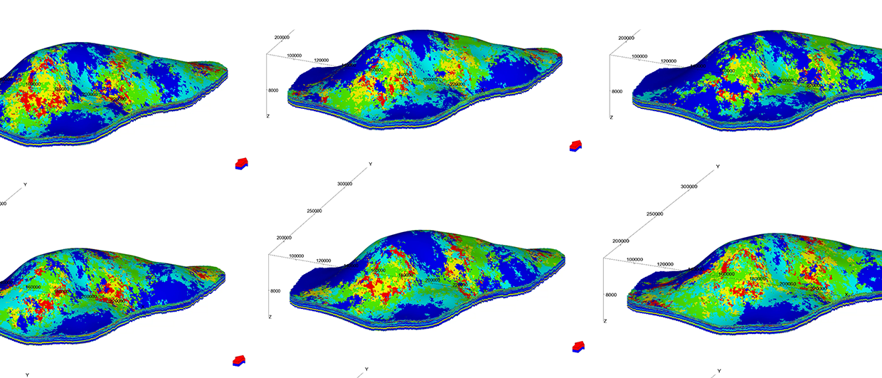
 Detailed geological model of fluvial delta created in Impala MPS. Source: Baker Hughes
 Turbidite fan model with trend for depositional energy. Source: Baker Hughes
 Impala facies modelling during sea level drop (A) and during sea level rise (B). The progression moves from an interior region (orange) through a tidal inlet region (green) to open marine conditions (blue). Source: Baker HughesAs part of its reservoir management platform, oilfield services company Baker Hughes offers the reservoir modelling software JewelSuite™. This product line can use add-ins, software applications that may be developed by third parties. Baker Hughes saw the need to improve the way reservoir models were generated, so were looking for suitable add-in programmes. As Jonathan Zwaan of Baker Hughes’ JewelSuite team says, “People want to build geologically realistic facies models, with shapes that they recognise, but where the modelling is done in a statistically sound way. We found this ability with the multiple point statistics software ‘Impala MPS’, produced by Swiss company Ephesia Consult. Impala has a unique performance with complex models and with the implementation of auxiliary variables. So we have incorporated it as a JewelSuite module”.
An example of Impala facies modelling is shown for a carbonate platform, modelled during a sea level drop when erosive channels were cutting into the atoll. Typically, such channels differ in shape between the platform interior and the edge of the platform where they become wider, showing a distinct trend. The modelling steps describe the trend from an interior region (orange) through a tidal inlet region (green) to open marine conditions (blue) and define the trend direction that points away from the central watershed of the platform.
A similar application of trend properties when superimposed on the same platform model during a sea level rise leads to another result containing details of different reef and lagoonal facies. In this case the properties were derived from a satellite image of a modern day atoll.
Many Depositional Environments
Christian Höcker, technical consultant at Baker Hughes, thinks that MPS is a very flexible method for facies modelling, capable of addressing many depositional environments and scales. He says, “The additional capability of Impala MPS regarding the use of trend properties is important as it greatly enhances ease of use. Other implementations require complex set-ups for laterally and vertically varying conditions, whereas with trend properties, I can use a single training image, covering a number of depositional settings, and be certain that the appropriate patterns are mapped into the respective locations in the simulation model.”
This ability can also be seen in a model of a turbidite fan generated from a simple training image with only one trend property – ‘depositional energy’.
A more complex 3D training image of a fluvial delta can be taken, by using simple trend properties, through a series of transgression/ regression cycles, resulting in a realistic and highly detailed geological model.
Christian concludes, “The examples show that – if properly applied – very simple training images can address complex needs. We have recently added features that make trend description and rotation really easy. This means that once reservoir modellers have understood some basic principles of MPS and tried the specific features of the JewelSuite implementation they will have a tool for all cases at their fingertips. And I am most happy to share training images and modelling recipes for various settings.”