In the current economic climate, reprocessing of legacy data can provide an attractive tool for exploration, infrastructure-led exploration (ILX) and even for production. In combination with state-of-the-art processing flows, legacy datasets may be revitalized to produce high quality imaging products, which may be used for field identification, planning and development. The new FSB Vision product (see map) is a powerful tool for operators to use in preparation for the UK 33rd Licensing Round, as well as for work programs after the award.
The benefits of reprocessing a large number of legacy surveys on a regional scale using an advanced processing sequence is presented here. The data, taken from the Faroe-Shetland Basin (FSB), West of Shetland, UK, comprises several input surveys covering over 24 000 sq. km, reprocessed through four phases, to provide a single, high quality and seamless regional dataset. The vintages of the surveys and their acquisition parameters vary greatly, with differing numbers and lengths of streamers, both single component and multisensor data, as well as various acquisition azimuths.
The FSB is known for having large lateral and vertical velocity gradients due to shallow injectites, alluvial deposits and intrusive and extrusive volcanics. As a result, high-end and robust velocity model building (VMB) is required to capture these variations and image them precisely. The VMB employed in this project is a combination of high-resolution Full Waveform Inversion (FWI) and reflection tomography, constrained by both geological interpretation and well data. We demonstrate the results of this integrated model building scheme from the initial phases of reprocessing.

The geological history suggests multiple target possibilities
The FSB is a NW-SE orientated deep-water rift basin, consisting of several ridges and sub-basins, located between the Faroe and Shetland islands on the north-western European Atlantic margin. The basin has a long and complex tectonic history and has experienced several periods of rifting in Permian-Triassic, Jurassic, Cretaceous and Paleocene, followed by thermal subsidence.
The basin was subjected to extensive igneous activity associated with the proto-Icelandic plume and seafloor spreading in the North-Atlantic during the Paleocene to Early Eocene. Thick sequences of basaltic lava flows were deposited, along with extensive emplacement of subsurface intrusive sill complexes. The Cenozoic period is signified by post-rift thermal subsidence and minor episodes of rifting, uplift and compressional events. The most promising targets are turbiditic or marine slope fan sandstones of Paleocene-Eocene age, fluvial systems and slope fans of Jurassic-Early Cretaceous age and Palaeozoic sandstones around the ridges.
Compensating for different acquisition configurations
To date, 23 (of the 38) legacy streamer surveys have been processed and incorporated into the study. These include multisensor and conventional data acquired between 1995 and 2013, consisting of variable acquisition parameters including azimuth and streamer number and length (varying between 3 and 8 km).
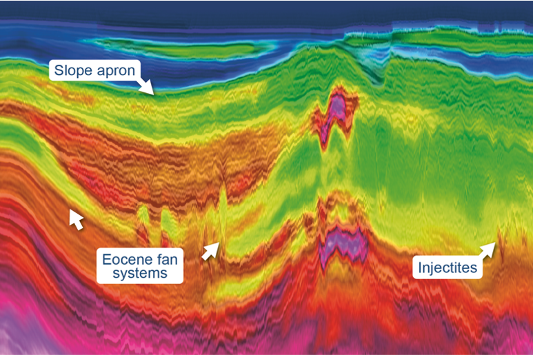
The water depth over the area varies between 500 – 1500 m, and the overburden is characterized by high-velocity Eocene fan deposits, sand injectites, polygonal faults, turbidite deposits and hydrothermal vents. Intra-volcanic reservoirs are encased in high-contrast flood plain basalts which provide a challenge for tomographic model building. Intermittent periods of volcanic activity produced varying quantities of intrusive complexes, basaltic lava and volcaniclastic material, with a large range of seismic velocities.
Due to the complexity in the overburden and the upper Tertiary (extrusive volcanics), obtaining an accurate high-resolution velocity model is beyond conventional tomographic techniques. As a result, FWI has been used to capture this complexity. We implement a classical multi-scale approach: moving from low to high frequencies and gradually growing the data selection based on the match between the observed and modeled response until most of the data was input to the inversion.
We use a unique imaging condition that separates the tomography from the impedance kernel in order to reduce the traditional dominance of high wavenumbers when reflections are involved in the inversion. As a result, the full wavefield contributed to the cost function and computed gradient, allowing for deeper updates and more consistent coverage, given the streamer numbers and length.
FWI was completed by inverting all surveys simultaneously in several passes to update a common model, progressively increasing the frequency of the update to 12 Hz. The result of this approach is displayed in Figure 2 and shows the velocity perturbations superimposed on the stack. This line transects both short offset single-sensor and longer offset multisensor data, shot with approximately 45o difference in azimuth. Despite these differences, the section is extremely well balanced, the depth of update is consistent, as is the magnitude within the different geological packages.

Figure 3 shows the long wavelength velocity model input to FWI and the final FWI velocity model. The new model is highly conformable with the geology, capturing the vertical layering present in the overburden and the small-scale features such as injectites. Figure 4 shows a depth slice through the overburden of the velocity model after FWI. It captures the strong lateral velocity variations caused by the polygonal faulting, injectites and alluvial deposits. The resolution is high across the area and there are no apparent survey boundaries, despite the differences in acquisition configurations.


Automatic picking of geobodies for velocity model constraint
Following FWI, the model build moved to the Mid Tertiary and Cretaceous sections. The workflow adopted for the intra-volcanic interval included the automatic picking of the volcanics and intrusions as geobodies. The use of geobodies was suitable as it was fast, accurate and allowed for an iterative picking approach to ensure an optimal result. Following this picking, the geobody volume was sculpted using the regional horizons to remove any errant picks.
The geobody volume, once finalized, was used during the subsequent tomographic updates to constrain the model and allow both a targeted high-resolution velocity variation within the intrusions/volcanics whilst preventing any leakage into the background model. Several iterations of the update were completed and resulted in a geologically conformable model that flattened the gathers and improved the stack response significantly. An example of the updated model is shown in Figure 5. The volcanics have been effectively updated using the geobody picking, they are well-defined with no apparent leakage into the background velocity model.

The value of (FSB) Vision
We demonstrated that applying advanced state-of-the-art processing solutions to a large number of vintage surveys results in highly detailed and accurate models that are consistent on a regional scale. We used a robust velocity model building workflow that leverages FWI updates and geologically constrained reflection tomography to resolve the large lateral and vertical velocity variations in the overburden and defined the sharp contrast geobodies in the mid and deeper sections. By doing this, we produced the FSB Vision product that has a highly conformable model with regards to the geology and that is validated by well data. As such, this project provides clear, regional broadband images of the Faroe-Shetland Basin, West of Shetland, ready to be used for UK 33rd Licensing Round assessments and work programs.
Acknowledgements
We thank PGS MultiClient for the permission to present this work.
References
Brandsberg-Dahl, S., Chemingui, N., Valenciano, A.A., Ramos-Martinez, J. and Qui, L. (2017): FWI for model updates in large-contrast media. The Leading Edge, 36(1), 81-87.
Ramos-Martinez, J., Crawley, S., Zou, Z., Valenciano, A.A., Qui, L. and Chemingui, N. (2016): A robust gradient for long wavelength FWI updates. 78th EAGE Conference and Exhibition, Extended Abstracts, Th SRS2 03.
Smallwood, J.R., Prescott, D. & Kirk, W. (2004): Alternatives in Paleocene exploration west of Shetland: a case study. Scottish Journal of Geology, 40, 131–143.
Smallwood, J.R.J. & Kirk, W.J. (2005): Paleocene exploration in the Faroe– Shetland Channel: Disappointments and discoveries. In: Doré, A.G. & Vining, B.A. (eds) Petroleum Geology: North-West Europe and Global Perspectives: Proceedings of the 6th Petroleum Geology Conference. Geological Society, London, 977–991.
White, N. & Lovell, B. (1997): Measuring the pulse of a plume with the sedimentary record. Nature, 387, 888–891