
When it comes to liquid-rich shale production and potential, the Bakken in North Dakota, Eagle Ford, and the Permian Basin shales of Texas have grabbed all the attention. However, the Cane Creek shale in south-eastern Utah has huge overall potential and may, on a per well basis, outdo those well-known areas. The US Geological Survey says there is a 95% confidence that it holds at least 103 MMbo and a 50% confidence rate of at least 198 MMbo. As for well production, a Fidelity E&P well in the Big Flat field produced about 700,000 barrels of oil in its first year, free-flowing to the surface.
The Utah Geological Survey (UGS) has an ongoing basin-wide research project, part of a three-year US Department of Energy funded study. Their scientists are analysing the geological, geomechanical and geochemical properties of the Cane Creek shale across the Paradox Basin to provide improved reservoir characterisation. The goals of this research are to identify potential exploration areas outside the current Cane Creek unit and to improve drilling and production techniques. The epifluorescence (EF) study is part of that research; most of the operators in this area are small independents not in a position to undertake such an extensive regional study.
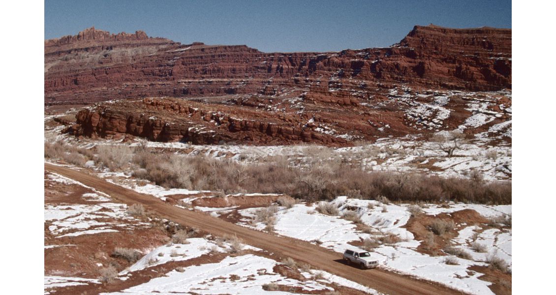
The Cane Creek Anticline was the location of the first oil discovery in the Moab, Utah area in the 1920s. This feature is just one of many spectacular anticlines that extend for miles in the fold and fault belt portion of the Paradox Basin. (Craig D. Morgan, Utah Geological Survey)
Paradox Basin
The ‘paradox’ originated in Paradox Valley in south-western Colorado. In 1875, geologist Albert Peale noted that the Dolores River had a “desire to perform strange and unexpected things”. Instead of flowing down the valley, the river emerges from a narrow gap, cuts perpendicularly across the centre of the valley and exits through another gap. This oddity or paradox was caused by the basin’s unique geology. The Paradox Valley occupies an eroded, salt-cored anticline and the river maintained its previously ancient course that was cut into the overlying bedrock. Moab Valley (Spanish Valley) located to the west in Utah has a similar geological history and is bisected by the Colorado River.
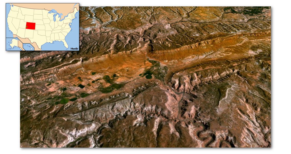
Simulated view of Paradox Valley in Colorado. Created with NASA’s World Wind software, version 1.4, using the LandSat 7 visible color layer. (Source: NASA)
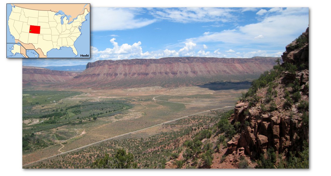
Looking down into Paradox Valley. (Source: Mark Iverson)
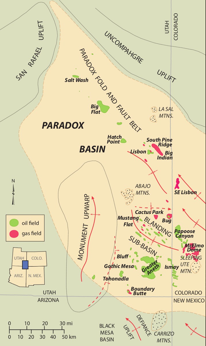 Location map for the Paradox Basin showing the Pennsylvanian oil fields. (Source: Utah Geological Survey)The Paradox Basin covers 85,470 km², primarily in south-east Utah and south-west Colorado, but extends into northern Arizona and New Mexico. The basin formed during Pennsylvanian (Late Carboniferous) time about 330 to 310 million years ago, when a series of fault-bounded uplifts and basins developed from Utah to Oklahoma as a result of continental collisions that formed the Ancestral Rockies. The Paradox Basin received a thick succession of cyclic carbonates, evaporites and organic-rich shales, now known as the Paradox Formation. The basin is divided into three areas: the fold and fault belt in the north, the Aneth platform in the south, and the Blanding sub-basin located between those two areas. Deposition in the northern portion of the basin (the Moab area) was in a highly restricted marine bay. Fluctuations in sea level left alternating thick deposits of halite and minor amounts of potassium and magnesium salts during low sea levels, while carbonates and siltstones with thin organic-rich shales were deposited during the high stands. There are 29 cycles in the Moab area; the Cane Creek shale was deposited in the highstand portion of cycle 21 in the lower Paradox Formation.
The first well in Utah was drilled in the northern end of the Paradox Basin near the town of Green River in 1891. Greater Aneth, Utah’s largest oil field, is located in the southern end of the basin. Discovered in 1956, the field has produced over 470 MMbo.
The Study
The first oil discoveries in the Pennsylvanian Cane Creek shale play occurred in the early 1960s. The most successful well drilled during this period was at Long Canyon field, which has produced over 1 MMbo, although most wells produced less than 70,000 bo before being plugged and abandoned. Exploration continued but significant success did not occur until Columbia Gas Development Corporation formed the Cane Creek Federal unit in 1991 and drilled a horizontal well, the first long-reach horizontal well in Utah. The company drilled six horizontal wells that have delivered over 1.4 MMbo and are still producing. Recently, Fidelity Exploration & Production Company took ownership of the field and has drilled 17 additional wells in the Cane Creek Federal unit. Now, with longer laterals and improved completions, well rates have dramatically increased and are expected to ultimately produce about 1.7 MMbo each.
The horizontal target is the B interval where the reservoir is primarily comprised of dolomite, sandstone and siltstone with both intercrystalline and microporosity. This interval is sandwiched by the A and C zones, consisting of organicrich shale, anhydrite and silty dolomite which serve as both the hydrocarbon source and as seals for the B interval. The entire Cane Creek interval is naturally fractured and overpressured. Production occurs in the fractured dolomites, sandstones and siltstones, usually on subtle subsidiary structural noses found associated with the major structures that trend south-east to north-west across the northern portion of the Paradox Basin. This area, known as the Paradox fold and fault belt, is crossed by large spectacular anticlines that are cored by salt.
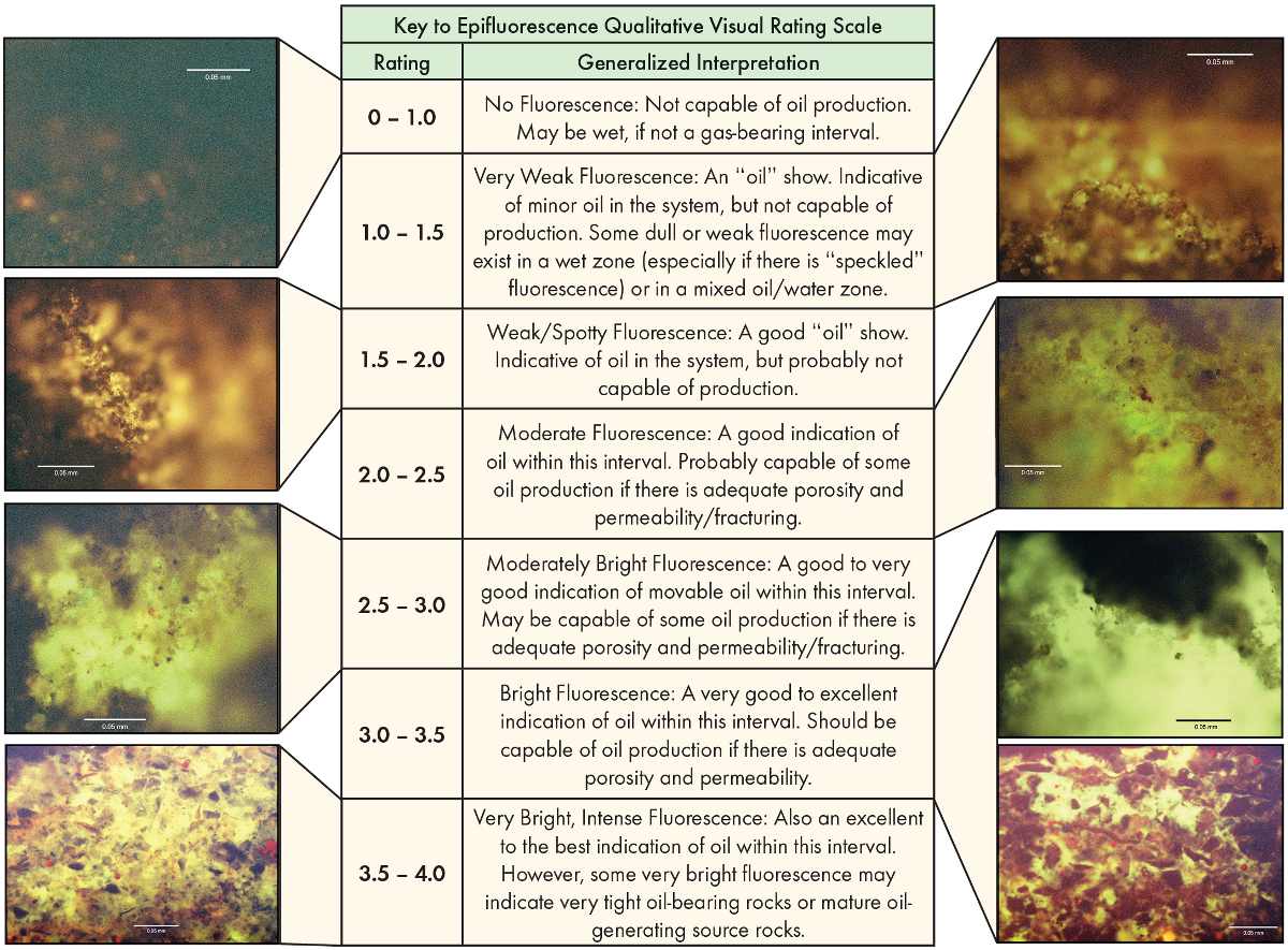 Micrographs showing examples of visually rated epifluorescence in the Cane Creek shale zone. (David E. Eby, Eby Petrography & Consulting, Inc.)Locating these subtle traps usually requires expensive, 3D seismic acquisition in often environmentally sensitive areas. To help high grade this large area outside the existing unit for lease acquisition and more detailed seismic mapping that could lead to exploratory drilling, UGS scientists working with Dr. David E. Eby, from Eby Petrography & Consulting, Inc., Denver, Colorado, have used the area’s extensive collection of cuttings, core chips and a limited number of thin sections to conduct this study. EF microscope techniques gave them a lowcost, non-destructive way to characterise the reservoir properties and organic matter including live hydrocarbons.
“Approximately 2,650 cuttings samples and core chips from the collection at the Utah Core Research Centre were evaluated from 31 wells penetrating the Cane Creek shale, including several producers,” explains Tom Chidsey, senior scientist at the UGS. “Cuttings were examined under a binocular microscope and representative samples were selected over the Cane Creek interval. Four to ten samples were analysed over each depth interval from each well. The cuttings or core chips were placed on Petrologs™, a small plastic, self-adhesive compartmentalised cuttings storage unit that made sample preparation quick and inexpensive for EF examination. All Petrologs used in this study are stored at the Utah Core Research Centre and are available to the public.”
Qualitative Mapping
“EF petrography makes it possible to clearly identify hydrocarbon shows in the Cane Creek cuttings,” says Chidsey. “The best images are obtained at relatively high magnifications (greater than 100x). A qualitative visual rating scale (a range and average) based on EF evaluation was applied to the group of cuttings or core chips. Using the qualitative visual rating scale, a variety of EF readings for each well were plotted and mapped. We mapped highest maximum and highest average for the total Cane Creek shale zone and then separated out the A, B, and C intervals. All the maps use the same ratings. Areas considered highly prospective for oil have ratings 2.0 or higher.” As expected, the EF ratings for productive Cane Creek wells were generally highest and served as a baseline in identifying potential.
“The Cane Creek interval is a difficult reservoir to explore and develop,” explains Chidsey. “Seismic mapping can identify potential drilling targets; however, identifying where good quality reservoirs exist is extremely difficult. Using low-cost EF analysis and mapping has identified a prospective north-west to south-east oriented fairway in the Cane Creek shale zone, whereas the north-eastern part of the Paradox fold and fault belt shows low EF values. The implication is that hydrocarbon migration in the Cane Creek dolomite beds was along regional north-west trending folds, faults and fracture zones, creating this relatively untested oil-prone area.
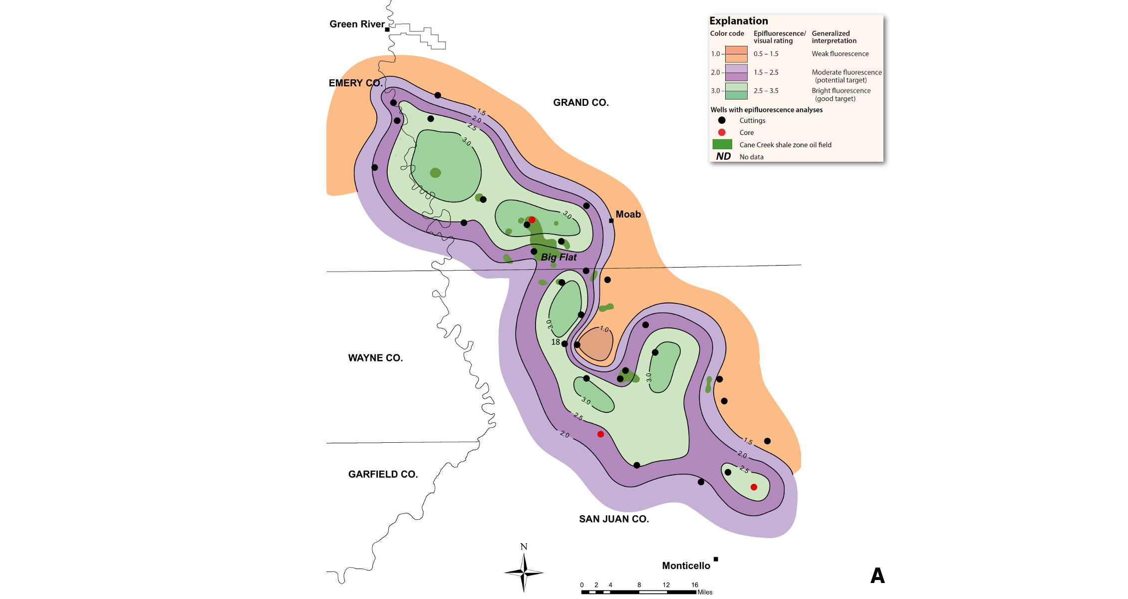
Maps showing highest maximum epifluorescence (A) and highest average epifluorescence (B) for Cane Creek B interval. A well-defined fairway with ratings 2.0 and higher (purple and greens) follows the same general trend as the total Cane Creek shale highest rating. All existing Cane Creek fields lie within this trend. Very prospective, largely untested B interval sections are present in lobes to the north-west and south-east of the Big Flat field, indicating the interval may not have uniform prospectivity along the favourable fairway. High-risk, less prospective areas occur to the north-east and south-west of the prospective fairway. (Source: Utah Geological Survey)
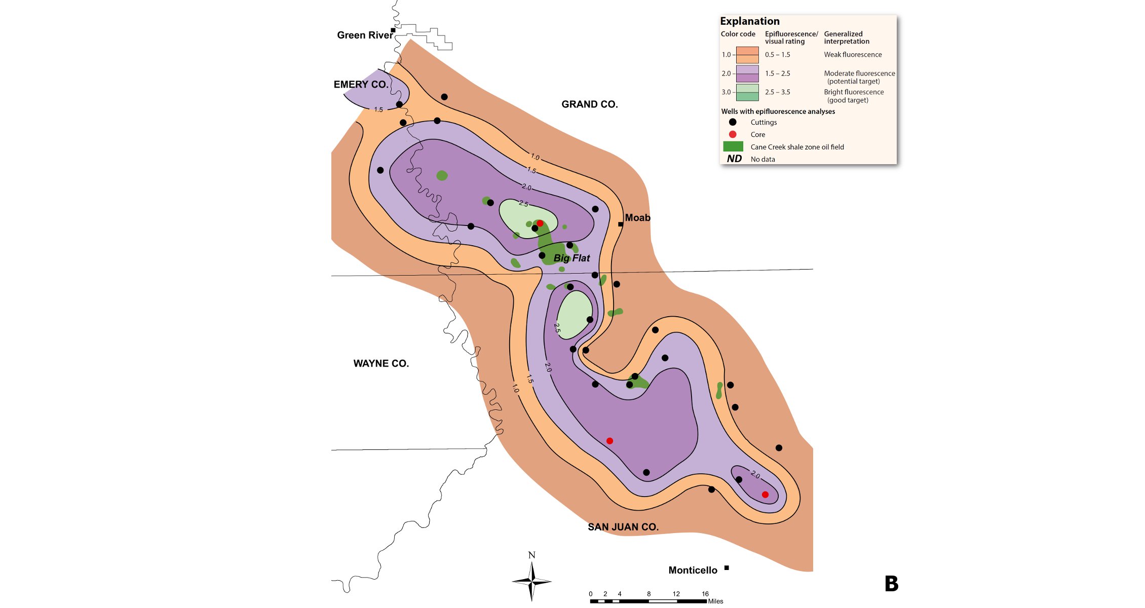
Maps showing highest maximum epifluorescence (A) and highest average epifluorescence (B) for Cane Creek B interval. A well-defined fairway with ratings 2.0 and higher (purple and greens) follows the same general trend as the total Cane Creek shale highest rating. All existing Cane Creek fields lie within this trend. Very prospective, largely untested B interval sections are present in lobes to the north-west and south-east of the Big Flat field, indicating the interval may not have uniform prospectivity along the favourable fairway. High-risk, less prospective areas occur to the north-east and south-west of the prospective fairway. (Source: Utah Geological Survey)
“EF analysis represents a low-cost method that can help quantify and delineate the ‘sweet spots’ and the potential areas in emerging tight oil plays around the world just as it has in the Cane Creek shale.”
The UGS and Eby previously conducted a similar EF study on the Mississippian Leadville Limestone, also in the Paradox Basin, which also showed areas with untested potential.


