Pre-salt Basins Identified in Gabon Deepwater Area
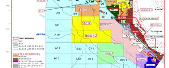
 Current Petroleum Domain as supplied by the DGH of Gabon. Open blocks in the offshore are shown in light blue colour.In support of the 10th Gabonese Licensing Round planned to be opened in May 2010, new seismic data, combined with an integrated study using potential field and geological data, has revealed significant pre-salt sediments in this complex basin. The pre-salt data resembles the geology observed around recent Brazilian pre-salt discoveries.
This expectation is the result of a series of initiatives aimed at mapping the hydrocarbon story of the region.
In Zone Nord, the interest is in the post-salt, with Tertiary and Upper Cretaceous La Ceiba analogues having the potential to contain large accumulations. Play concepts have been proven in Equatorial Guinea and shallow water areas and new data are being acquired to highlight the areas of interest.
Yet the biggest potential for Gabon lies within the prospectivity of the pre-salt section. The pre-salt hydrocarbon system has been very successfully exploited in the onshore and shallow water areas of the South Gabon Basin but it has never been explored in the deep water areas. However, recent major oil discoveries in the deep waters off Brazil have stimulated interest in Gabon’s deep water. New seismic data from CGGVeritas is helping to reveal the pre-salt potential.
Regional Geology
 The South Atlantic at the Early syn-rift stage.
 The South Atlantic at the Late Syn-Rift Stage.
 Brazilian and West African oil families. Source: USGS, 2006.
 Brazilian and West Coast African Basins.
 In order to assess the deepwater potential of Gabon it is helpful to look at the geological history around the time of South Atlantic rifting and the depositional systems that existed within the rift. The formation of the Douala, Rio Muni, Gabon, Congo and Kwanza basins along the west coast of Africa began in the Early Cretaceous, during the breakup of Gondwana and subsequent opening of the South Atlantic Ocean.
Early rift sediments include the Neocomian age Basal Sandstone which forms a viable reservoir in onshore and shallow water fields. The overlying Kissenda shale is a good source rock though not as rich as later pre-rift shales such as the middle Barremian-age Melania organic rich black shale, a rich lacustrine source rock with an average TOC of 6.1%. Later rift deposits include reservoir-quality sediments culminating in lacustrine deltaics of the early Aptian Dentale formation with excellent porosity and permeability.
A transitional erosion and peneplanation phase followed rifting, culminating in a marine transgression during which the Gamba sandstone, the principal reservoir in the shallow water Gamba field (discovered in 1967), was deposited. Again this reservoir rock has excellent porosity and permeability.
Deposition of the Gamba was followed by a period of salt deposition during the late Aptian, during which approximately 500 m of Ezanga salt accumulated. The salt provides a perfect seal to the Gamba and other syn-rift reservoirs.
During the drift to sag phase, marine carbonates and shales were deposited over the Ezanga salt and it was during this time that salt tectonism was initiated. The Upper Cretaceous saw a period of deposition of clastics followed by uplift and erosion so that uppermost Cretaceous and Paleocene sediments are missing from the section. Clastic deposition continued during the Eocene but further uplift and erosion resulted in removal or non-deposition of Oligocene sediments in Gabon.
Many reconstructions have been made across the South Atlantic Ocean to indicate possible relationships between Brazilian and West African basins. The top figure on page 40 clearly shows the correlation via transform faults on the free air gravity map. This shows a link between the Sergipe/Alagoas Basin in Brazil and the North Gabon Basin and between the Reconcavo Basin and the South Gabon Salt Basin. The map below confirms this link showing correlations of families of oils and their distributions, depositional environments of source rocks and major basins, in work done by Schiefelbein et al and modified by the USGS.
Hydrocarbon Systems
A number of different petroleum systems are present and have been exploited onshore and in the shelf region of the offshore province but, as yet, there has been little exploration in the deepwater regions. Seismic data indicates the extension of the Ezanga salt province into the deeper water together with probable Dentale and Gamba Formations in the South Gabon sub-basin.
Source rocks and hydrocarbon generation
Probably the most important source rocks are the Neocomian to Aptian shales of the Melania and Kissenda formations in the South Gabon sub-basin with average TOCs of between 6.1% and 1.5-2% respectively. In the North Gabon sub-basin, the Melania formation may be present but has not been penetrated by drilling and the Kissenda formation has only been encountered in onshore wells.
Good Tertiary source rocks are also present along the margin but are generally immature.
Oil generation along the margin from early Cretaceous source rocks has been active since the late Cretaceous with the maturity window moving westward over time with continued downwarping (Edwards and Bignell, 1988). The Madiela, Azile and Cap Lopez formations did not mature until the Miocene (Teisserenc and Villemin, 1990).
Reservoir rocks
There are numerous potential reservoir rocks in the Lower Cretaceous of the North and South Gabon sub-basins. The Basal Sandstone formation, which exhibits porosity up to 25% and permeability up to 100mD, is extensive across the South Gabon sub-basin but has not been penetrated by drilling in the North Gabon sub-basin, although it is expected to be present from seismic interpretation. Also in the South Gabon sub-basin, sandstone members of the Melania formation exhibit porositiy of 18-32% and permeability of 10mD to 2D. The Barremian age Dentale formation has porosity up to 29% and permeability up to 1D while the extensive Gamba formation has porosity from 20-30% and permeability from 100mD to 5D.
Post-salt Cretaceous reservoirs are also present as platform sands of the Anguille, Pointe Clairette and Weze formations or as sand-rich channels within the deepwater turbidite systems.
Traps and Seals
 Schematic geological cross-section across the South Gabon Basin showing potential source and reservoir intervals and play types.Pre-salt traps comprise tilted fault blocks sealed by shales or salt and structural closures associated with salt movement. Drape structures are also expected over the fault blocks (Gamba reservoir). Post-salt traps comprise drapes over salt domes sealed by shales or combination structural/stratigraphic traps of sand-rich channels within turbidite systems (compare cross-section on the bottom of page 40).
Comprehensive Work Program
 Some 13,000 km of seismic data have been acquired offshore Gabon in preparation for the 10th licensing round.The complexity of the geology requires a robust seismic acquisition and advanced imaging workflow to high-grade blocks. This has been accomplished through a multi-phase approach, designed to improve understanding of this complex basin.
Basin modeling was performed and results are available, providing a unique suite of data covering the Zone Sud area. An integrated workflow was undertaken combining the new test seismic acquisition with interpretation of vintage data and inversion of potential field data.
Gravity Gradiometry which records high-resolution, multi-tensor gravity data providing lateral positioning information on the location of salt bodies was also acquired. The data is being used to derive a 3D model of the salt geometry for accurate earth modeling and can be incorporated into depth models for future prestack depth migration.
Acquisition and processing of nearly 13,000 km of new 2D seismic data covering both Zones (Sud and Nord) was performed. Data acquisition and time processing are completed with depth processing underway. In Zone Sud, the pre-salt required acquisition parameters using the same parameters as the test line including long-offset, deep-tow acquisition, maximizing low-frequency energy penetration. For Zone Nord, the survey was complicated by pre- and post-salt plays. To image both targets successfully, the data was acquired with two cables placed at different depths. These record the high-frequency, high-resolution data for the Tertiary/Upper Cretaceous targets alongside the low-frequency, deep-tow data required for the pre-salt targets.
Additional recent-vintage 2D and 3D data is also being reprocessed.
World-Class Provinces
The comprehensive project performed on the new tracts of Gabonese acreage planned to be offered to the industry in 2010 demonstrates all the attributes and potential for these tracts to become world-class petroleum provinces of the future. The approach, using existing and new seismic data specifically tuned to unravel the complexity of structure below the salt, has helped to deliver this potential. The pre-salt section of Gabon is revealed as having multiple indicators of significant prospectivity. Clearly there is considerable potential in the pre-salt of Gabon.


