Huge potential in undrilled Southern Santos Basin
The prospectivity of the deepwater outboard Santos Basin is revealed by new 3D seismic.
With a daily oil production in the region of 2.6 MMbo (ANP, 2018), Brazil is among the ten largest oil producers in the world. Just under half of Brazilian oil production comes from the pre-salt carbonate reservoirs of the Santos and Campos Basins. Production from sag-phase and syn-rift (Aptian and Neocomian) reservoirs dates back almost to the start of exploration and production in the Campos Basin, where Neocomian vesolitic and fractured basalt and Barremian coquinas were put into production in the Badejo and other fields. However, significant exploration of, and production from, the pre-salt Lower Cretaceous carbonate reservoirs of the Santos and Campos Basins did not occur until the 2006 discovery of the giant Tupi/Lula field in the Santos Basin and the 2008 development of the pre-salt carbonates in the Campos Basin Jubarte field. Further discoveries of pre-salt fields in the Campos Basin (some below extant fields in Late Cretaceous to Miocene turbidite sands) followed, including the Parque das Baleias fields from 2010. Production from the Lula and Sapinhoa fields in the Santos Basin began in 2013, and other fields have followed, including Carioca/Lapa (2016) and Franco/Buzios (2018).
Fast-track Santos 3D volume available
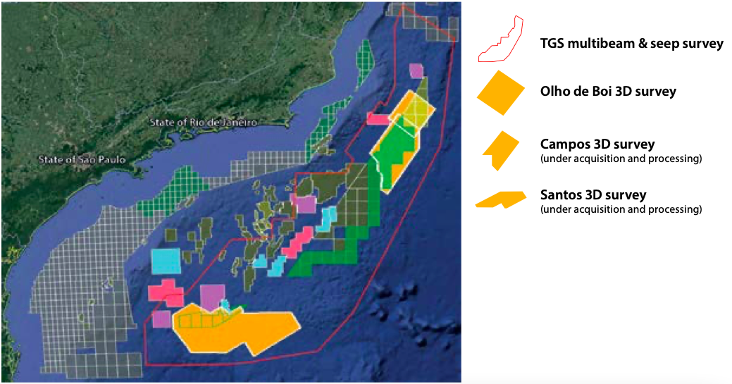
A fast-track sub-volume (3,370 km2) of the Santos 3D volume is now available for inspection before the upcoming license rounds. This sub-volume shows only a small portion of the larger study area, but it is sufficient to validate the main findings of the 2D seismic surveys:
- there are large four-way dip closures at base-salt level;
- the seismic facies indicate the presence of the Barra Velha Formation beneath the salt;
- syn-rift grabens and half-grabens containing potential source rocks flank the structural highs.
Regional setting and exploration activity in the deepwater Santos Basin
South America and Africa were part of Gondwana until separated by Late Jurassic-Neocomian rifting, when horst and graben structures developed in trends roughly perpendicular to current coastlines. In both Brazil and Angola, a transition is seen from proximal fluvial-alluvial clastic-dominated facies to widespread deposition of lacustrine facies. Shallow water lacustrine carbonate reservoirs developed locally on or around horsts, whilst coeval organic-rich shales (associated source rocks) accumulated in the grabens and halfgrabens. The end of major rifting is marked by a regional angular unconformity, with carbonates and shales infilling the late syn-rift to sag basins. Increasing salinity of the lacustrine environment culminated in deposition of thick salt, which ended with the start of seafloor spreading and the resulting opening up of the restricted rift basin. Late Aptian-Albian shallow marine carbonates were deposited on the salt. Platform carbonates and their deepwater equivalents dominate the Albian–Cenomanian. The Upper Cretaceous to Tertiary is mainly characterized by siliciclastic deposition.
Initial development of the pre-salt play in the Santos Basin focused around the northern and central areas inboard of the Outer High of the Santos Basin, including Libra/Mero and Franco/Buzios in the north; Iara, Tupi/Lula, Jupiter and Pau Brasil in the centre; and Sul de Guara and Peroba in the south. The primary reservoir for these fields is a high porosity and permeability sag-phase carbonate facies (K46-48: Barra Velha Formation) sealed by the overlying salt. This usually presents as horizontal to low angle, low-frequency, good to moderate continuity, high amplitude reflectors (TGS, 2013). There is usually little to no evidence of major faulting of this formation in most of the Santos Basin.
Bioclastic limestones (Itapema Formation/coquinas), at the top of the major rift phase and in the lower part of the sag basin, are a potential secondary carbonate reservoir. They are typically present as stacked banks of reworked shelly fragments deposited along lake margins and are found in deep to shallow lacustrine environments. The corresponding seismic facies is moderate to good amplitude, moderate continuity, parallel to sub-parallel (TGS, 2013). Coqueiros reservoirs have been reported as oil-bearing at Seat and Pão de Açúcar in the Campos Basin, and in the Mero, Buzios and Lula fields in the Santos Basin. The main source rock for the Santos Basin pre-salt fields occurs in the lower syn-rift (K36).
As these early discoveries have matured to producing fields, exploration has moved south and east into more outboard areas. Exploration interest has been sustained by improved understanding of the environment of deposition of the main pre-salt reservoir (the Barra Velha Formation), by extensive 3D seismic surveys, including the Santos 3D discussed here, and by innovations in the licensing regime, such as frequent licensing rounds and permanently offered blocks. Three exploration rounds in 2018 raised record bid amounts, lifting expectations for three more licensing rounds (Concession Round 16, Pre-Salt Production Sharing Contract Round 6 and the Transfer of Rights Surplus round) for which public bidding is scheduled for Q4 2019.
Complex salt and faulting in the southern Santos Basin
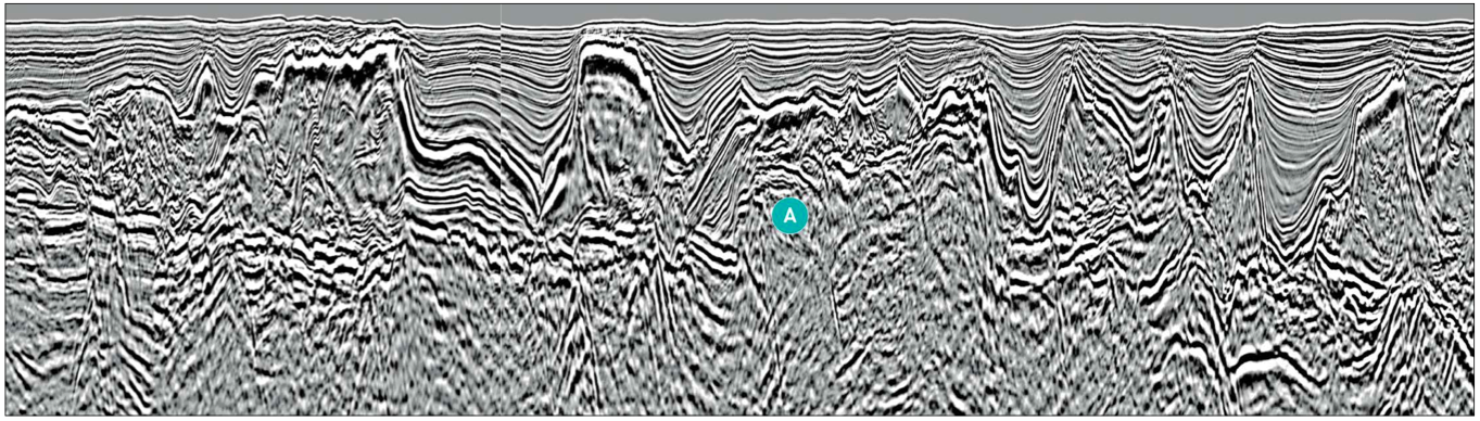
The evaporite sequence is seen to comprise both ‘stratified’ and diapiric sections, signifying the presence of not just halite but additional evaporite minerals (e.g. anhydrite, carnallite, tachyhydrite). The presence of this ‘dirty salt’ requires that a common offset RTM (COR) be applied to update the salt body velocity. Complex internal deformation (thrusting and folding) is evident in the salt sequences. A feature of particular interest in much of the study area is the apparent large fault-throws at base of salt level. This is not an anomalous feature of the present study area: similar features have been noted in the PSC Round 5 Saturno and Dione prospects (Petersohn, 2018). These faults appear to have normal throws, with kilometers of offset, often larger at the pre-salt level than in the underlying syn-rift level. This suggests that syn-rift faults were re-activated during or very shortly after Late Aptian salt deposition. Note in the seismic foldout how reflectors in the hanging-wall salt (A) onlap the plane of the fault with high angle. This may suggest a significant degree of local rotation within the evaporite sequence caused by fault movement and/or salt dissolution.
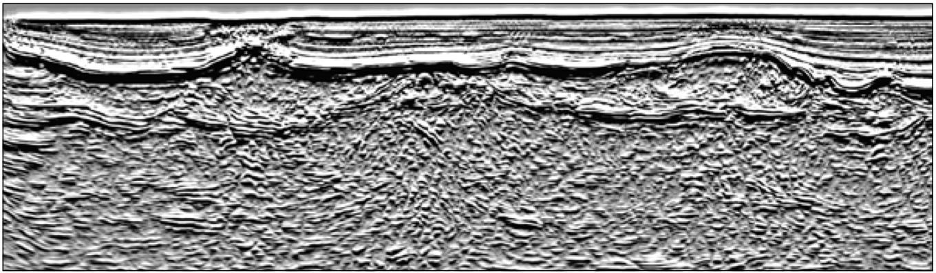
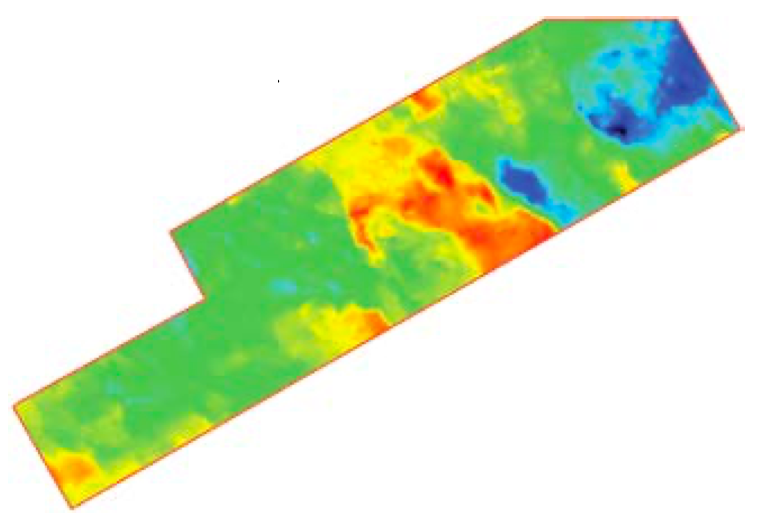
Figure 3 shows a map of the Base-Salt horizon throughout the fast-track sub-volume. It shows a series of small north-west to south-east trending four-way dip closures flanking a major high, also trending north-west to south-east. Much larger four-way dip structural closures have been mapped on the Spectrum (now TGS) 2D seismic data throughout the study area (Spectrum, 2018). Seismic facies criteria (see above; TGS, 2013) outline the Barra Velha Formation immediately under the salt and confirm its minimum thickness throughout the fast-track subvolume to be greater than 200m. In much of the fast-track sub-volume the Barra Velha Formation unconformably overlies the syn-rift succession. On the structural highs, it appears often to unconformably overlie basement.
A brief overview of new 3D seismic in the deepwater Santos Basin
This has been a brief review of a fast-track sub-volume that constitutes a little more than an eighth of the greater TGS-Spectrum Santos 3D; any comments on such a small and intermediate sub-volume are necessarily limited. However, analysis of this data does support the findings of the 2D seismic data that large structural closures at Barra Velha Formation level are present throughout the project area, together with flanking grabens and half-graben areas filled by syn-rift sediments (prospective kitchen areas and secondary coquina facies secondary carbonate reservoirs). These findings support the prospectivity of this entirely undrilled area of the southern Santos Basin and are essential viewing for any companies interested in the upcoming PSC 6 and future license rounds.


