
The Hoop Basin
The Hoop Fault Complex has been a focus area for several exploration companies since 2009 when the first 3D seismic data set covering the area was acquired by TGS. Five exploration wells have been drilled, resulting in two light oil discoveries in good Jurassic reservoir rocks. The relatively shallow exploration targets make the area suitable for geophysical methods other than ‘normal’ 2D and 3D seismic data. Industry demands higher resolution data, so the large Hoop Fault Complex data set has been reprocessed using broadband processing techniques and P-Cable 2D and 3D seismic is being acquired.
Structural geology
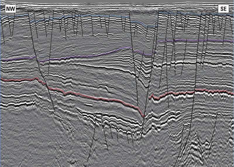
The Hoop Fault Complex has experienced several episodes of faulting. Deep in the section faults cut Carboniferous and possibly older strata, while the Triassic, Jurassic and Cretaceous successions are offset by a younger series of faults trending north-north-east to south-south-west. These faults and successions make up the characteristic Hoop Graben. Overprinting these episodes of faulting, the Upper Triassic to the onset of the Cretaceous section has also been affected by a late east-west trending fault system. These are important for the definition of fault-bounded structural closures in the Jurassic section, which have been targeted in the successful Wisting Central and Hanssen wells. The different structural styles seen in the Hoop Fault Complex can have major implications for the migration and re-migration of hydrocarbons into the shallow structures.
Potential reservoir rocks
Post-Eocene erosion has removed a lot of Cretaceous and possibly younger strata from the Hoop Fault Complex area, with implications for hydrocarbon exploration, as it has made older strata more easily accessible.
In certain areas the Permian and possibly the Carboniferous section are shallow enough to be considered exploration targets. Carbonate buildups are possible reservoirs in this section. Carbonate rocks that have experienced subaerial exposure might have developed good secondary porosity. With Lundin’s exploration success on the Gohta prospect further south in the Barents Sea in mind, this is something that should be explored.
The most prominent sedimentary features in the Hoop Fault Complex area are the deltaic deposits of the Triassic, which can be seen as large-scale north-west prograding clinoform packages, thinning north-westwards. The most westerly position of the paleo-coastline appears to be in the Hoop Fault Complex area for the Klappmyss, Kobbe and Snadd Formations. Statoil’s Atlantis well, which tested the Triassic section in a large closure adjacent to the Hoop Graben, was not successful; the main target was the Middle Triassic Kobbe Formation, but the result was a small gas discovery in thin Upper Triassic sands. An excellent oil-prone marine source rock in the Steinkobbe Member of the Kobbe Formation of the Middle Triassic has been confirmed by Sintef IKU’s shallow stratigraphic boreholes near the Svalis dome. Large deltaic channel systems of the Upper Triassic Snadd Formation can be seen as bright amplitude anomalies on seismic data. More exploration effort and the use of higher resolution data is needed to thoroughly explore the Triassic section in this area.
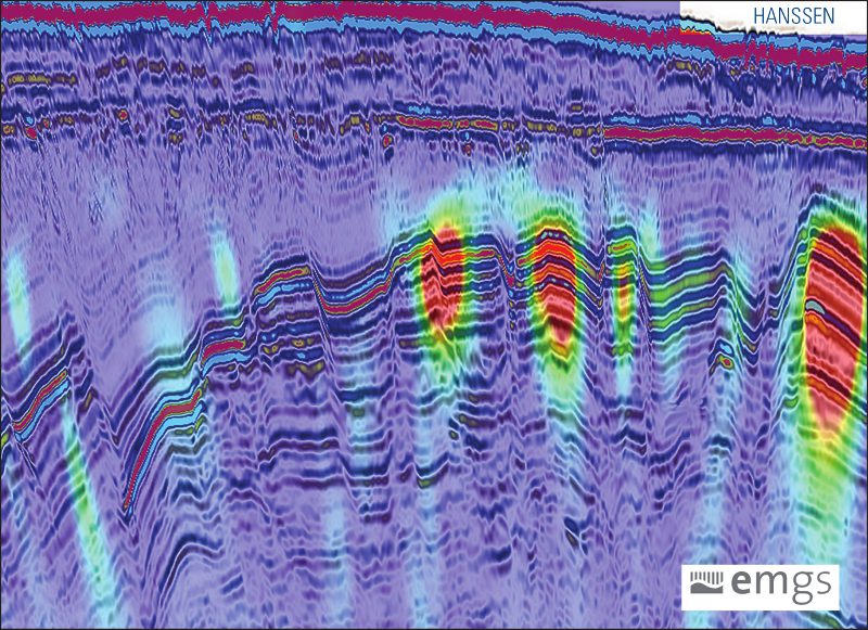
So far the Jurassic succession has been the most successful for hydrocarbon exploration. The Upper Jurassic Hekkingen Formation source rock is believed to be mature along the flanks of the basins adjacent to the Hoop Fault Complex. Excellent reservoirs have been confirmed, and oil has been proven in two recent wells, Wisting Central and Hanssen, with oil in Jurassic fault blocks approximately 500 to 800m below the seabed. Both discoveries were supported by bright amplitude anomalies, flat spots and distinct anomalies on CSEM data. Another recent well, Apollo, HANSSEN targeted a Jurassic fault block, but there were no flat spots or positive CSEM anomalies; the well was dry. The recent Mercury well tested Jurassic reservoirs in a CSEM-supported fault block closure, but only a small gas discovery was made. Many structures supported by flat spots, amplitude and CSEM anomalies can be found in the 23rd licensing round blocks and elsewhere in the Hoop Fault Complex area.
In the Hoop Graben and the Fingerdjupet sub-basin further west, varying thicknesses of the Lower Cretaceous succession have been preserved. The Cretaceous section can be seen as large clinoforms resulting from south-south-east coastal progradation events. Erosion products from footwall uplift along major faults can be deposited in the basin as good reservoir rocks.
Hoop and geophysical methods
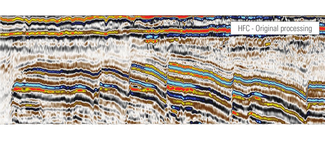
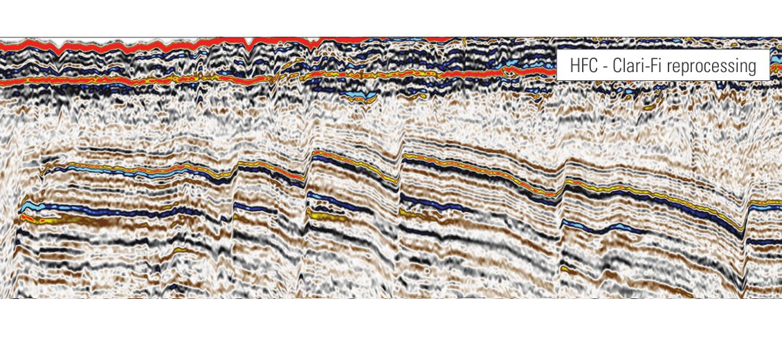
Increased interest from the industry and recent exploration success has made the Hoop Fault Complex area an area for acquisition of many kinds of geophysical data. Since the first acquisition in 2009, more 3D data have been acquired each year, and the TGS multi-client 3D coverage is now over 20,000 km² and spans from the Stappen High in the west to past the Hoop Graben in the east. Shallow discoveries and similar leads in the Jurassic section call for a better resolution in the seismic data, and by using the TGS Clari-Fi™ processing technique, the 3D data have been de-ghosted and the frequency range of the upper part of the seismic section has nearly been doubled.
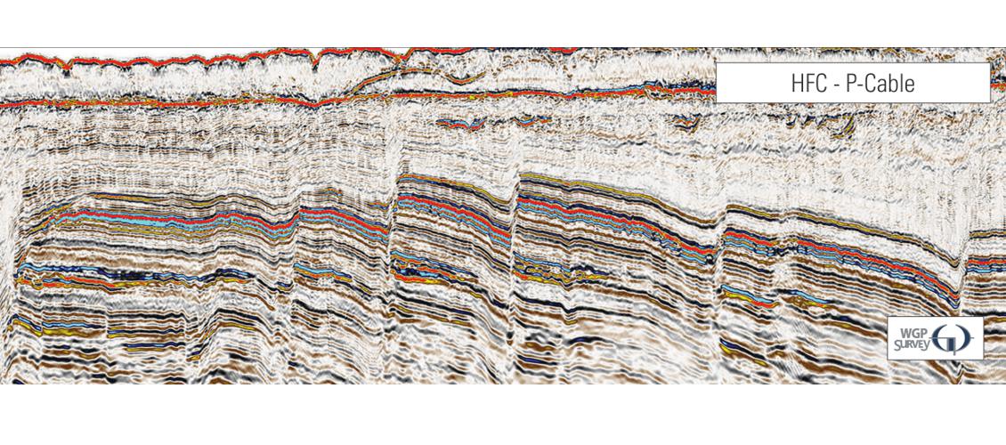
TGS is currently acquiring P-Cable 2D and 3D data in collaboration with WGP-Survey. Acquired using 16 streamers with 12.5m streamer separation, the data are extremely high resolution. The P-Cable data sets have frequencies up to 250 Hz, and provide an excellent image of the reservoirs, fluid contacts and migration paths for the Jurassic section.
There are many examples showing that CSEM is a valuable geophysical method in the Hoop Fault Complex area. Both the Wisting Central and Hanssen discoveries were supported by positive CSEM anomalies, as was the small gas discovery in the Mercury prospect. TGS and EMGS have jointly acquired CSEM data in the area. While CSEM anomalies are not all equally easy to understand, many structures with anomalies similar to Wisting Central and Hanssen can be applied for in the 23rd licensing round.
TGS and VBPR are currently conducting seafloor sampling in the Hoop area. The aim of the survey is to characterize the fluid phase (oil vs. gas) of potentially charged structures. The recovered samples will follow a comprehensive analytical program, including standard seep studies (APT), amplified geochemical imaging (AGI), microbiological investigations (MicroPro) and biostratigraphy (APT). The results can provide a new insight into the subsurface geology and petroleum systems of the area. The sampling locations are selected based on the re-processed Hoop Fault Complex 3D data set as well as P-Cable data.
Integration of data sets
Integration of different geophysical and geological data sets is essential for efficient exploration in the Hoop area. It is a complex region and one data set alone will not provide all the answers. TGS offers a turn-key suite of products for exploration in this highly prospective area, from micro- to macro-scale. Long offset 2D and the 20,000 km² of broadband processed 3D enables TGS’ clients to understand the regional geology, map all structural closures, and examine sediments ranging in age from Carboniferous or older to Quaternary. It will also give the opportunity to perform AVO studies on the many leads and prospects. The shallow Jurassic leads can be examined in the greatest detail using P-Cable 2D and 3D data, and CSEM will help understand the presence and saturation of hydrocarbons in the structures. Further de-risking of prospects can be done by examining the results from the seafloor sampling, as the transects cover many of the most relevant structures in the 23rd licensing round blocks and can give important information on fluid phase in charged structures.
More information can be found on the TGS website.


