Improved imaging and new insights
The MSGBC Basin is the largest of the offshore northwest African Atlantic Margin basins, covering some 600,000 km2 and extending almost 1,500 km along the margin from the Cap Blanc Fracture Zone in northern Mauritania, south through Senegal, Guinea-Bissau and Conarky to the Guinea Fracture Zone in the south. The basin can be divided into a number of sub-basins aligned in a north-south direction and delimited by east-west fault systems related to syn-rift tectonics. The sub-basins between the fracture zones have similar overall architecture yet each sub-basin has a different sedimentary and tectonic history. This, in part, is related to presence or absence of salt.
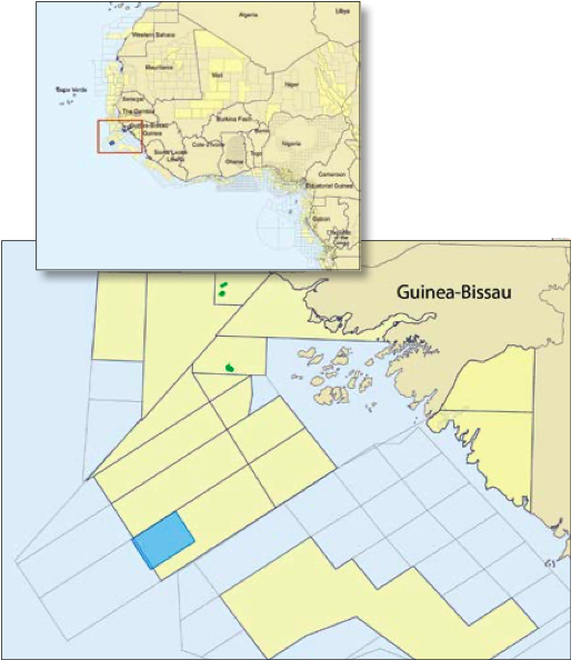
Polarcus, in collaboration with Petroguin and GeoPartners Ltd, acquired in 2013 approximately 2,380 km2 of broadband multi-client 3D seismic data within Block 7B, offshore Guinea-Bissau. The data provide significantly improved imaging and provide new insights into the exploration potential of the area and the wider region.
Interesting structures
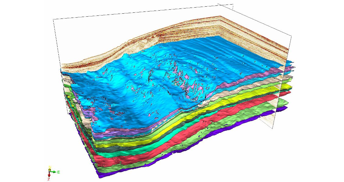
Guinea-Bissau Block 7B lies within the Casamance sub-basin, the southernmost of the MSGBC Basins. The Polarcus 3D covers the shelf to basin transition in the south-western area of the block, with water depths ranging from 150m to 1,500m. The foldout line shows a typical cross-section, exhibiting the variation in structural and stratigraphic character across the shelf-slope break.
Break-up of the Pangaea supercontinent in the MSGBC Basin area began during the Late Permian to Early Triassic. The syn-rift sequence consists of Triassic to Lower Jurassic clastic sediments deposited in a series of grabens and half-grabens as the region extended, in some areas with the development of evaporites. The overlying post-rift sequence consists of Jurassic to recent clastic and carbonate units, with reefal facies in the Lower Cretaceous, and the possibility of laterally extensive Upper Cretaceous turbidite deposits as recognised in Senegal to the north. The carbonate shelf was eventually shut down by clastic input from deltas prograding from the east. The salt layers which are characteristic of other areas of the MSGBC Basin thin towards the south-eastern part of offshore Guinea-Bissau and interplay with the Upper Cretaceous fan systems.
The Casamance sub-basin has a history of exploration with a number of discoveries (Dome Flore, Dome Gea, Sinapa) and several wells encountering oil shows (PGO-3, PGO-2, BASS-1). Exploration to date, using only 2D seismic data, has been focused on the more shallow water near shore areas, where a variety of clastic and carbonate reservoir horizons have been encountered by historic drilling. Reservoir quality is good to excellent in several of these wells; however, to date no wells have been drilled in the deeper water areas. The wells in the northern part of the basin targeted deep anticlinal structures and those in the central part of the basin sought salt-related traps.
Two geological regions
To evaluate the geology and gain insights into the prospectivity of Block 7B, Lyme Bay Consulting Ltd applied their Detailed Reconnaissance Study (DRS) workflow to the Polarcus 3D dataset. The DRS builds a geological representation based on the underlying seismic data, a GeoModel, which calculates and correlates the relationship between 3D seismic points according to the similarity of the wavelets and their distance from each other. This process automatically tracked every reflector within the seismic volume where a relative geological time/depth was computed for every point, producing a horizon for each and every reflector within the dataset. Attributes were then calculated from the original input seismic and overlain on the horizons to deliver a high resolution reconnaissance tool to enable identification of structural and stratigraphic features within the 3D volume.
Offshore Guinea-Bissau can be broadly divided into two geological regions: a shallow water relatively tectonically quiescent area, and a deeper water highly deformed collapsed margin.
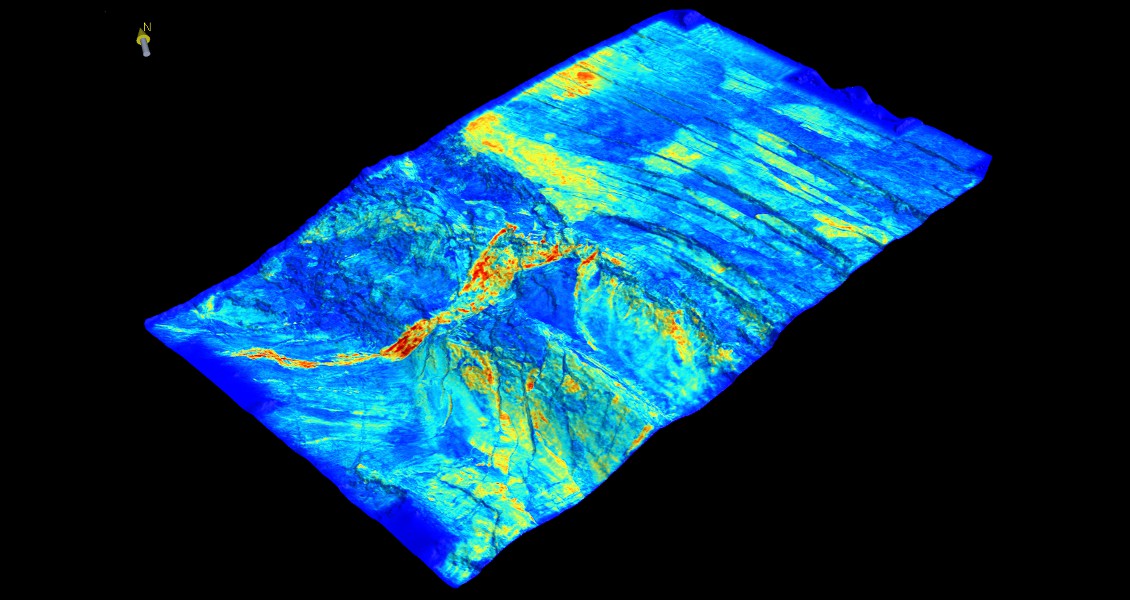
The shallow water platform area is characterised by the Guinea Plateau, a large marginal plateau clearly seen on the free air gravity and bathymetry maps. This consists of Jurassic and Lower Cretaceous carbonates overlain by Cretaceous to Tertiary clastic sediments. The Tertiary sequence displays well developed polygonal faulting due to fluid overpressure and expulsion. Beneath this a series of north-north-west – southsouth- east trending grabens, half-grabens and horst blocks can be seen throughout the Cretaceous sequence below a regional Senonian Unconformity (see image above) which has removed some 1–2 km of strata from the outer margin of the bank. Within the Cretaceous sequence faulting can be seen to be generally laterally extensive; deeper in the Mesozoic section the DRS has, however, illustrated a different tectonic fabric with less laterally extensive faulting, displaying a more north-south orientation.
Seaward of the Guinea Plateau, the Mesozoic and Tertiary sediments have been heavily deformed by structures (slumps, listric faults, folds, etc.) generated by the gravitational collapse of the sedimentary cover along the margin. The collapse led to a highly complex interplay of tectonics with multiple levels of detachment.

Several play types
The main play types expected within the 7B Block are: Upper Jurassic and Lower Cretaceous marine carbonates (providing both source and reservoir) with the potential also for a Lower Cretaceous lacustrine source, Lower Cretaceous (Aptian-Albian) clastics with Cretaceous-Jurassic source, and Upper Cretaceous (Cenomanian- Turonian) clastics with a Cretaceous source. The presence of a working petroleum system is suggested by numerous oil seeps and surface geochemical samples as well as the nearby well results and discoveries.
Frequent structural closures can be observed on the 3D data. A key to evaluating the prospectivity of the deeper water areas, however, is understanding the potential for clastic input into any potential play fairways. The DRS study has shown clear evidence of a number of channel systems throughout the Cretaceous sequence on the margin slope to basin area (see image below). A major depositional system has been recognised extending from the area of the shelf-slope break into the deeper marine offshore area. A number of other smaller scale distributory systems have also been recognised, generally consisting of channel systems, in places showing amalgamation and deflection against structural relief.
Historic seismic data has not been of sufficient quality, or had adequate coverage, to allow proper investigation of the plays beyond the shelf slope break. The basin-ward extension of the reservoirs encountered by historic exploration has therefore, to date, been unknown. Analogy to other deepwater basins in West Africa and elsewhere suggests these facies may be potentially excellent reservoirs. The DRS study provides clear evidence, hitherto unavailable, of potential reservoir sands being delivered to the basin over an extended period of time. Both structural and stratigraphic traps have been identified and the new seismic data and DRS study provide fresh encouragement that the deepwater may contain all the necessary elements of a successful petroleum system.