Gippsland Basin – enhanced understanding unlocks new deepwater opportunities
A new high-quality 3D data set imaged with the latest technologies reveals previously unseen depositional elements, with strong implications for petroleum system presence.
The Gippsland Basin is Australia’s premier oil-producing basin covering approximately 46,000 km2, primarily offshore Victoria. Over the past four years, CGG has undertaken a multi-phase data enhancement and acquisition project, commencing with a major basin-scale reprocessing initiative, and culminating in the completion of a new 3D acquisition and imaging project.
The Gippsland ReGeneration reprocessing project, undertaken in 2018, demonstrated the enhanced potential for new CGG imaging technologies to generate important new insights, particularly throughout underexplored areas beyond the present-day shelf break. These insights highlighted the need
for new and expanded data coverage beyond the existing shallow water exploration areas. Correspondingly, CGG developed the new expanded 3D seismic acquisition project. This multiclient survey was acquired in 2020 and final data processing, with CGG’s latest proprietary imaging technologies, reached completion in 2021.
The new survey has provided expanded data coverage from the inboard shallow water areas, through the Central Deep, and into the previously unexplored deep-water areas. Preliminary interpretation of the final processed data has yielded key insights that further enhance the understanding of petroleum system elements and the prospectivity of the deep-water areas.
Gippsland Basin geological setting
The Gippsland Basin is part of a series of west-east trending southern margin basins, including the Bass and Otway Basins that formed contemporaneously throughout multiple rift and drift phases (Tosolini et al, 1999).
The first of the main rift phases was associated with the Early Cretaceous continental breakup of Australia and Antarctica. This was followed by the opening of the Tasman Sea along a NNESSW axis during the Late Cretaceous (Yang et al, 2019). An episode of compression occurred during the Early Eocene to Early Miocene, as a result of the convergence of the Australian and Southeast Asian plates, and seafloor spreading within the Southern Ocean (Power et al, 2001).
The main stratigraphic subdivisions of the basin are the early rift Strzelecki Group, the Late Cretaceous to Oligocene Latrobe Group, and the Oligocene to Miocene Seaspray Group. The Latrobe Group has historically been the primary exploration target and represents the main exploration focus within the offshore areas (Bernecker et al, 2001). The Latrobe Formation reservoir targets have been charged primarily by coal-derived source rocks, deposited in upper coastal plain settings (Bishop, 2000).
Re-imaging the Gippsland Basin
For CGG’s initial ReGeneration reprocessing project, several key technologies were applied to the pre-existing 16 vintages of 3D data. These included 3D joint source and receiver deghosting, the latest fullwaveform inversion and least-squares Q pre-stack depth migration (QPSDM). The resulting uplift in data quality achieved for ReGeneration was pivotal for enhancing interpretation capabilities and generating new insights, in particular for the deep water. These insights led to the development of the new 3D acquisition project, which further leveraged the ReGeneration data results for the optimization of velocity model building, filling areas without data coverage, and as an additional azimuth for the final stack.
To further enhance interpretation capabilities of the data, the new multiclient 3D survey was acquired utilising P/Z components, longer cable lengths, and the latest imaging technologies. These included time-lag full-waveform inversion (TLFWI) with 15-Hz maximum frequency, 3D P-Z joint de-ghosting and de-signature, 3D interbed multiple attenuation, Q tomography, and Least-Squares QPSDM dual-azimuth optimized stack.
The new imaging flow generated significant benefits for the Gippsland Basin data, including:
- High-resolution velocity and well-tie across the whole survey
- High signal-to-noise ratio and coherency of events, from shallow overburden, to deeper, sub-carbonate successions
- A sharper image from the shallow-water to new deep-water coverage areas throughout the Gippsland Basin.
New 3D data – insights & opportunities
For both the ReGeneration and new 3D volumes, CGG undertook interpretation, both throughout and after completion of the processing sequence. The main objectives were to assist with velocity model building and develop a framework for detailed interpretation of the final processed data.
The resulting interpretation of the ReGeneration volumes provided a strong foundation for preliminary interpretation of the newly acquired 3D data, particularly for the expanded deep-water coverage. This provided a unique opportunity to test and expand upon pre-existing insights and develop new concepts for prospectivity. These included an enhanced structural understanding and identification of previously unknown, or poorly understood, depositional systems and features.
One of the key interpretation techniques applied to both the ReGeneration and new 3D volumes was the generation and analysis of seismic attribute volumes, including spectral decomposition and amplitude attribute volumes. The following examples demonstrate some of the interpretation capabilities and opportunities made possible by the new data.
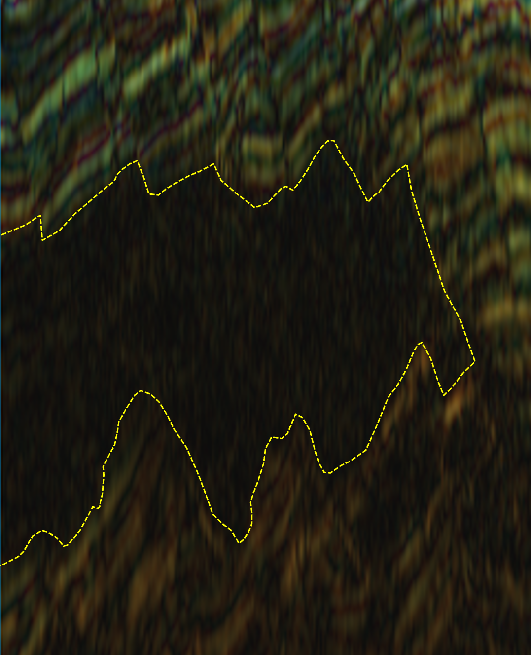
The example in Figure 2 is a spectral decomposition colour-blend image generated using a third-party interpretation software. The example highlights a newly observed, thick depositional feature, with distinctly different seismic characteristics to the overlying and underlying successions. This contrasting lack of internal reflectivity is consistent with massive, very fine-grained depositional facies, such as shale or mudstone.
The feature identified and mapped within the deep-water area is located immediately below the Longtom Unconformity which separates the Late Cretaceous Golden Beach and Emperor Sub-groups. The distinguishing seismic characteristics and stratigraphic level of this feature suggest a possible correlation with early rift, intra-cratonic lacustrine shale deposition (Emperor Sub-group Kipper Shale), or a marine shale time-equivalent. These lacustrine shales typically have high levels of organic, terrestrial input and have been identified as widespread with good source rock potential in other parts of the basin.
Importantly, this feature could not be mapped to its full extent with pre-existing data quality and coverage beyond the present-day shelf break. This demonstrates potential within the present-day, deep-water areas of the basin for widespread deposition of source rock facies within early rift, intra-cratonic depocenters.
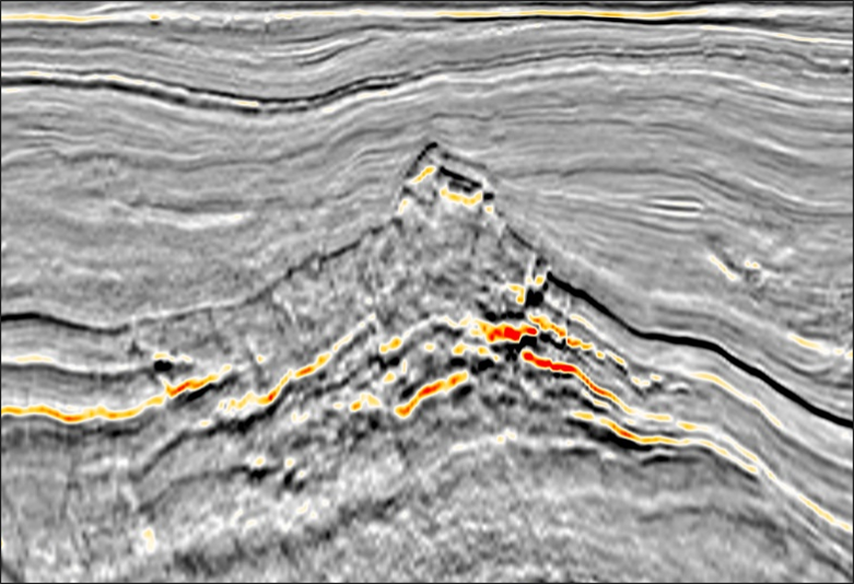
Another key example of newly identified features within the deep-water areas can be seen in Figure 3. It is also highlighted on the main foldout seismic line. This example shows an extrusive volcanic edifice that was never seen before, interpreted as a well-preserved cinder cone within the present-day deep-water area.
While extrusive volcanics are not typically associated with petroleum system elements, the presence of this feature in association and potentially coeval with the interpreted shale body, strongly validates the proposed depositional environment concepts.
These new insights have only been made possible through the acquisition of expanded 3D data coverage and the application of the latest, advanced processing techniques. The features observed and discussed herein highlight the presence of previously unknown or poorly understood depositional systems in the deep water, and advance our understanding of the distribution and interplay of these elements.
While the full exploration potential of the deep-water Gippsland Basin is yet to be revealed, the new data is already unlocking previously unseen depositional elements, with strong implications for petroleum system presence.
Acknowledgements
The author wishes to thank CGG Subsurface Imaging for their significant contribution to these results.
References
Bernecker T., Woollands M.A., Wong D., Moore D.H., Smith M.A., 2001, APPEA Journal 2001, 91-113, 93
Bishop M.G., 2000, Petroleum system of the Gippsland Basin, Australia, U.S. Geological Survey E-Bulletin, Open-File Report 99-50-Q, 1
Power M.R., Hill K.C., Hoffman N., Bernecker T., Norvick M., 2001, The structural and tectonic evolution of the Gippsland Basin: Results from 2D section balancing and 3D structural modelling, PESA Eastern Australasian Basins Symposium, Melbourne, Victoria, November 2001, 1
Tosolini A-M.P., Drinnan A.N., McCloughlin S., 1999, Stratigraphy and fluvial sedimentary facies of the Neocomian lower Strzelecki Group, Gippsland Basin, Victoria, Australian Journal of Earth Sciences (1999) 46, 951
Yang X., Smith G., 2019, Gippsland Basin 3D forward modelling in Badlands, ASEG Extended Abstracts, 2019, 1


