
GeoStreamer X: a fast and efficient solution
A faster, smarter solution tailored to the geological and geophysical challenges and with a significantly reduced environmental footprint.
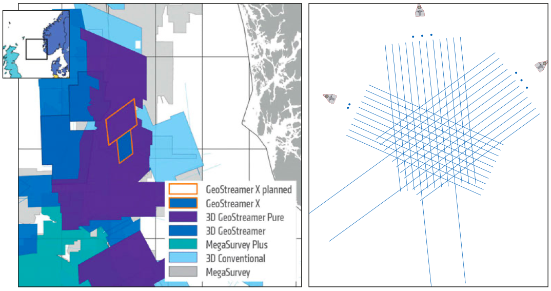
The pioneering new acquisition configuration used by PGS for this survey combines wide-towed sources close to the multisensor streamers with longer offsets and multi-azimuths. The result is a high-resolution, multi-azimuth illumination seismic dataset with an accurate velocity model and robust and reliable AVO attributes. It is suitable for near-field exploration, appraisal and development. Being acquired with 12 streamers on a ten-streamer pre-plot also makes the dataset suitable as a 4D baseline.
As shown in Figure 1, the 2019 acquisition added two new azimuths and used a 12 × 6 km × 85m high-density multisensor streamer spread, including two 10-km long streamer tails, and a wide-towed triple source with 225m separation between outer source arrays. These additional azimuths are complementary to the existing GeoStreamer multi-client data coverage from 2011. All three datasets form the basis of an efficient azimuth- and offset-rich acquisition and imaging solution designed to resolve the main geological and geophysical challenges in the area.
Wide-towed sources: multiple benefits
The GeoStreamer X Viking Graben survey demonstrates full coverage of reliable near offsets in the 50–125m range. The improved near-offset coverage is achieved by distributing multiple sources widely along the front end of the streamer spread, thereby increasing confidence in the AVO attributes. Reducing the distance from the outer streamer to the nearest source enables towing of wider streamer spreads, which increases lateral data coverage and provides efficiency gains in acquisition. The extension of two streamers to 10 km for the two new directions, combined with the wide triple source set-up, generates appropriate sampling for a velocity survey using full waveform inversion (FWI).
Resolving the shallow to reveal the deep
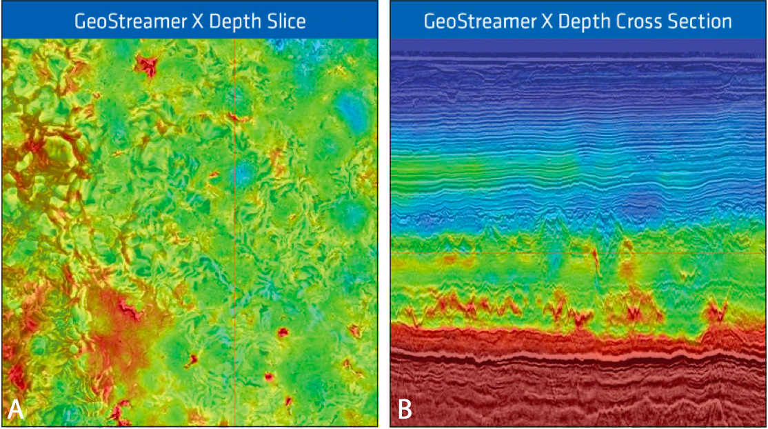
The MAZ time slice (Figure 3B) reveals a number of large channels within the first 50 – 350 ms below the seabed. With a conventional acquisition set-up (one azimuth), imaging of these channels has been an issue due to the lack of near-offset data. The original survey configuration shows clear acquisition footprint (Figure 3A) which can have a detrimental effect on amplitude analysis and interpretation. While the sail-line related amplitude footprint may be mitigated in processing, the lack of detail in the image has serious consequences for shallow amplitude analysis, be it for drilling hazard identification or shallow prospectivity analysis (for example in the Barents Sea). Properly resolving and characterising these channels provides a clear improvement in the seismic section underneath.

The early-out GeoStreamer X products have delivered on expectations, in terms of both timing and quality, as seen on the seismic examples in Figure 3. There is a significant increase in signal-to-noise ratio and clear indications of illumination improvements. The full benefits will be revealed when utilising all of the azimuthal data simultaneously in the velocity model building work and the final imaging stages. The full integrity processing is ongoing and includes a complete rework of the 2011 velocity model to take full advantage of the rich offset and azimuth distribution from the new acquisition. At present, the bulk of the low wavenumber updates using refraction data for FWI are complete. This focuses the early inversions using the 10 km long-offset datafrom the two new survey directions and provides a stable and accurate background velocity model. Anisotropy was incorporated and will be reviewed with the more detailed velocity updates based on reflection data (the latter is a mix of FWI and ray-based tomography).
As illustrated in Figure 4, the velocity model is already updated at all depths, down to the acoustic basement. The first rounds of inversions were performed using frequencies from 2 Hz to 9 Hz and were effectively able to pick up both low and high velocity anomalies. It is worth noting that some of the velocity contrasts are rather weak but nonetheless important, and validating the velocity model correlation with the seismic requires that we observed both small and large contrasts. In the examples shown in Figure 4 the intermediate depths are highlighted as they show complex sand systems and mounds. The resolution of this particular interval was considerably improved due to the increased fold and additional azimuths provided by the long offset data between 6 and 10 km. The long streamer tails have contributed to both increased penetration depth and increased overburden accuracy in FWI.
The ongoing work with the higher resolution velocity updates will resolve thinner layering, in the order of tens of metres, and sharpen velocity contrasts as well as give a higher dynamic range in the velocities. Ultimately, with the improved illumination at the imaging stage, all the final pre-stack depth data will benefit from minimal angular and azimuthal misfits and can be optimally combined. This not only reduces noise in the image, but also improves resolution, depth accuracy and interpretability.
Define challenge – apply technology
GeoStreamer X is a flexible acquisition and imaging integrated solution tailored to the geological and geophysical challenges, be it illumination and resolution of injectites in the Viking Graben, shallow targets in shallow water such as in the Barents Sea or better illumination around salt structures in Brazil. The ambitious goal of GeoStreamer X is to deliver an effective solution for improved reservoir insight. Using a single Ramform vessel, geoscience teams were provided with the early-out MAZ PSDM seismic data three months after the last shot, delivering superior data quality efficiently with a turnaround comparable to a conventional NAZ survey. GeoStreamer X has proved to be a faster and smarter solution than nodes with a significantly reduced environmental footprint as an added bonus.
Further reading on seismic acquisition from PGS in the Viking Graben
Sand Injectites in the Viking Graben, North Sea
Noemie Pernin, Laurent Feuilleabois, Tim Bird & Cyrille Reiser; PGS.
PGS superior GeoStreamer PURE pre-stack broadband seismic imaging reveals super producer hydrocarbon discoveries in the North Sea Viking Graben injectite structures.
This article appeared in Vol. 15, No. 3 – 2018


