The region south of the Kara Sea (Figure 1) is part of the Yamal-Nenets Autonomous District (YaNAO), and the crater has attracted great attention partly because of its proximity (only 3.5 km) to the Bovanenkovo-Ukhta high pressure gas pipeline – and also its size: the average diameter of the crater and the parapet are 26 and 37m respectively, while its depth is about 50m (Figure 2) [1-8, 11]. It soon became clear that the Yamal crater (C1 on Figure 1) is similar to a number of other objects discovered on the Yamal and Gydan Peninsulas.
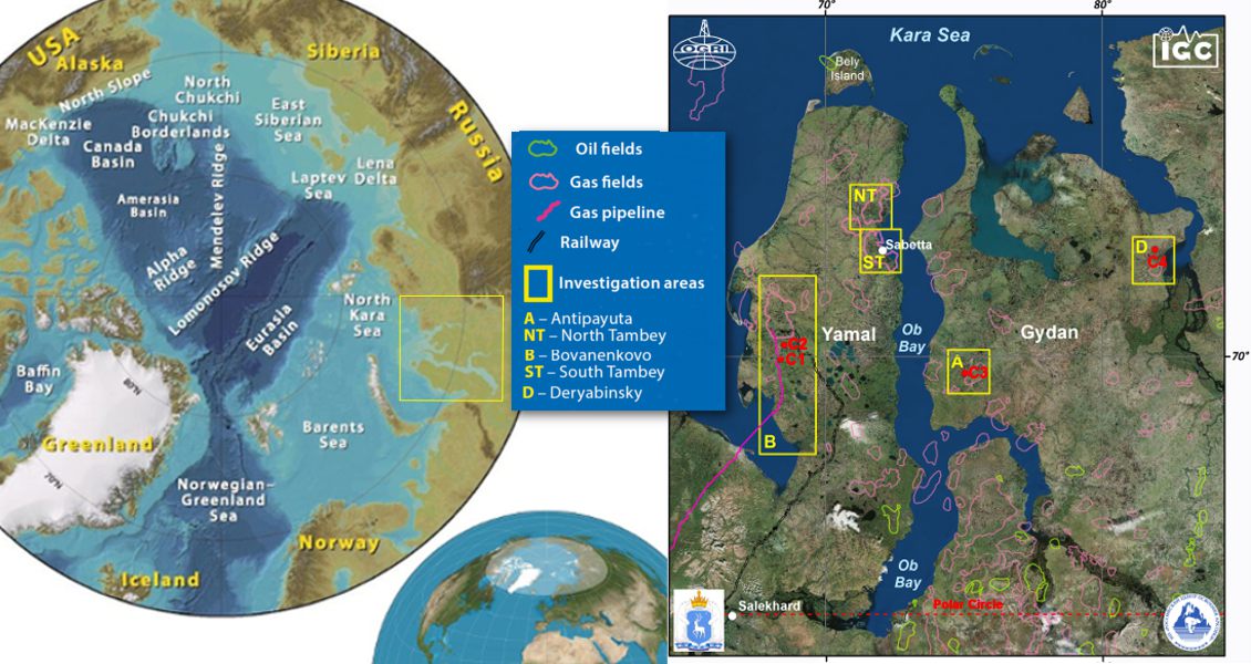
Figure 1: The location of craters C1, C2, C3 and C4 in the Yamal and Gydan Peninsulas region.
Several hypotheses have been suggested to explain the formation of these craters, including a hit by a meteorite or a UFO, or the collapse of an underground gas facility. All the craters look like the results of huge explosions.
Pockmarks and Pingos
As soon as information about the Yamal crater appeared on the internet, the Russian Arctic Development Centre (RADC), a nonprofit partnership of scientific organisations, including the Oil and Gas Research Institute of Russian Academy of Sciences (OGRI RAS), started investigations. RADC was established in 2014 in Salekhard (the capital of YaNAO, located on the Arctic Circle) on the orders of President Vladimir Putin and YaNAO Governor Dmitriy Kobylkin. Since then the Centre has sent seven expeditions to different parts of the Yamal Peninsula, and I was able to participate in four of them. In spite of modern airports at Bovanenkovo and Sabetta, expensive helicopters remain the primary transport mode for the expeditions, so we use satellite imagery to investigate the landscape and to help them understand what took place in the crater areas before the unknown ‘explosions’ [2-7].

Figure 2: Gas blowout crater C1 on the Yamal Peninsula – (A) on 8 July 2015, photographed from a helicopter, (B) with the author standing beside same crater shown on 25 August 2014, and (C) from the parapet, also from 25 August 2014. (Source: Vasily Bogoyavlensky)

Figure 2: Gas blowout crater C1 on the Yamal Peninsula – (A) on 8 July 2015, photographed from a helicopter, (B) with the author standing beside same crater shown on 25 August 2014, and (C) from the parapet, also from 25 August 2014. (Source: Vasily Bogoyavlensky)

Figure 2: Gas blowout crater C1 on the Yamal Peninsula – (A) on 8 July 2015, photographed from a helicopter, (B) with the author standing beside same crater shown on 25 August 2014, and (C) from the parapet, also from 25 August 2014. (Source: Vasily Bogoyavlensky)
One of my main scientific work themes for many years has been the investigation of underwater fault zones, mud volcanoes, gas pockets, pockmarks, gas-hydrates and other examples of heterogeneities from the upper subsea section, especially in the Arctic seas. Because of the close nature of sea and land concepts in geology, I proposed that the mechanism forming these craters was the same as that which created pockmarks generated by gas blowouts offshore, except that in Yamal and Gydan the onshore gas comes from thermokarst caverns and other collectors under and inside the permafrost layers, which are about 200–400m thick.
The Cenomanian Upper Cretaceous sand, which is a regional gas reservoir, is very shallow (500–1,200m) and the biggest gas fields, including Bovanenkovo, Urengoy, Yamburg and Zapolyarnoye were discovered in this horizon. Gas rising to the surface through the systems of faults and cracks causes overpressure in the palaeo-permafrost clay layers and breaks through the weakened parts of it, forming the gas springs and blowout craters. There are lots of relict gas craters – pockmarks – in different parts of the World Ocean [3, 4, 6, 13]. Gas under high pressure destroys melted permafrost (taliks) in deep lakes, rivers and even thin layers of frozen rocks like those on frost mounds at the bottom of former lakes. Additionally, gas inflows could come from dissociation of gas hydrate detected in the Bovanenkovo field area [12].
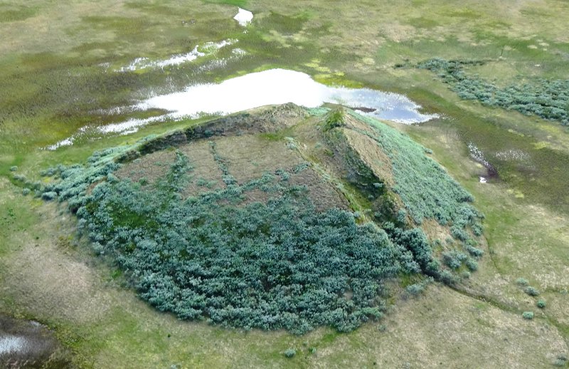 Figure 3: A typical pingo to the south of Bovanenkovo field, July 2015. (Source: Vasily Bogoyavlensky)Frost mounds, called bulgunnyakhs (Yakut language) in Russia and pingos (little hill in Inuit) in other countries, geologically appear as hydrolaccolites with ice cores formed from frozen ground water under high pressure. Figure 3 shows a typical pingo 100m in diameter, which is situated in the area. About 1,350 similar pingos have been discovered on the Tuktoyaktuk Peninsula in Canada (GEO ExPro, Vol. 10, No. 1 – Geochemical Surface Expression of Oil and Gas in Arctic Terrains) [14]. Basically, after a long period of growth the upper part of the pingo (the soil covering the ice core) cracks and the ice core melts, forming a round lake. It is known that sometimes these ice mounds explode under excessive ice pressure.
We suggest that in some cases frost mounds can be formed not only by the growing ice core, but also by the pressure of underlying gas deposits.
Exploring the Craters
The locations of the Canadian pingos are well known, but in Russia less attention has been paid to the issue. Pingos are of interest not only for scientific study, but also to ensure the safe functioning of oil and gas infrastructure and domestic and industrial buildings.
On 8 November 2014 the director of RADC, Vladimir Pushkarev, and four other specialists were the first in the world to descend into the gas blowout crater C1 (Figure 4) [7]. During the examination samples of rock which formed the walls of the crater were taken, eventually showing that they are made entirely from ice up to 30m thick. Ground-penetrating radar studies inside the crater proved the presence of sub-vertical channels of gas migration (supposedly a fault), which had caused the explosion of the frost mound.
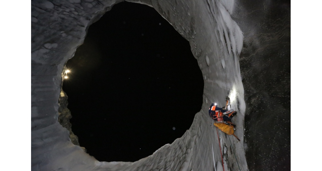
Figure 4: Ice sampling in crater C1, looking up from the bottom of the crater, 8 November 2014. (Source: Vladimir Pushkarev)
An expedition on 8 July 2015 found C1 almost filled with water (Figure 2), confirming our hypothesis that in a short period of time (2–3 years) the craters turn into lakes like thousands of others on the Yamal Peninsula. Our analysis of the satellite images taken in 2014 put the time of the blowout to be between September 2013 and June 2014 [5]. We suggest that conclusions published in 2015 (A. Kizyakov et al. [8]) dating the crater formation to between 9 October and 1 November 2013 are erroneous, preferring the dates of 21 February to 3 April 2014 proposed by O. Sizov [11].
Complex retrospective analysis of satellite images and data from expeditions shows the presence of frost mounds at the location of every crater studied (C1–C4), confirmed by the ice rocks seen bursting out of all four craters. These frost mounds did not exhibit the large cracks seen on pingos (Figure 3). The ‘Sever- Press’ news agency reported an explosion with fire and smoke and an earthquake experienced by locals on 27 September 2013 near the site of C3 (Figure 5) in the Antipayuta area of the Gydan Peninsula. Caverns, thought to possibly be the channels of gas inflow, were seen at the bottom of C1 and C3 before they filled with water, which had happened by the end of August 2015.

Figure 5: Ice walls of C3 crater in Antipayuta area on Gydan Peninsula, 19 April 2014. (Source: M. Lapsuy)
On 4 April 2013 deer-breeder S. Yaptune was the first man to see crater C4, after the locals heard an explosion in the tundra during March. From photos and the description given by S. Yaptune, the crater was about 4m across and over 60m deep. Fragments of rocks ejected from the crater were found up to 900m away, proving that the explosion was caused by gas combustion. According to QuickBird satellite data, by 19 June, 2013 the average diameter of the crater and parapet were approximately 16 and 33m (Figure 6). It is hard to imagine that the crater could expand to more than four times its original diameter in only four months, three of which were freezing, so the only rational explanation is repeated gas blowouts.
There are probably several craters in the Deryabinsky area, but we know the coordinates of only one, C4, recorded in 2014 by V. Epifanov, the first geologist to study this crater. We have information about more than ten surface craters, including the crater discovered from helicopter by Vladimir Yakushev in 2010 [6], but we still do not know the detailed location of some of them.
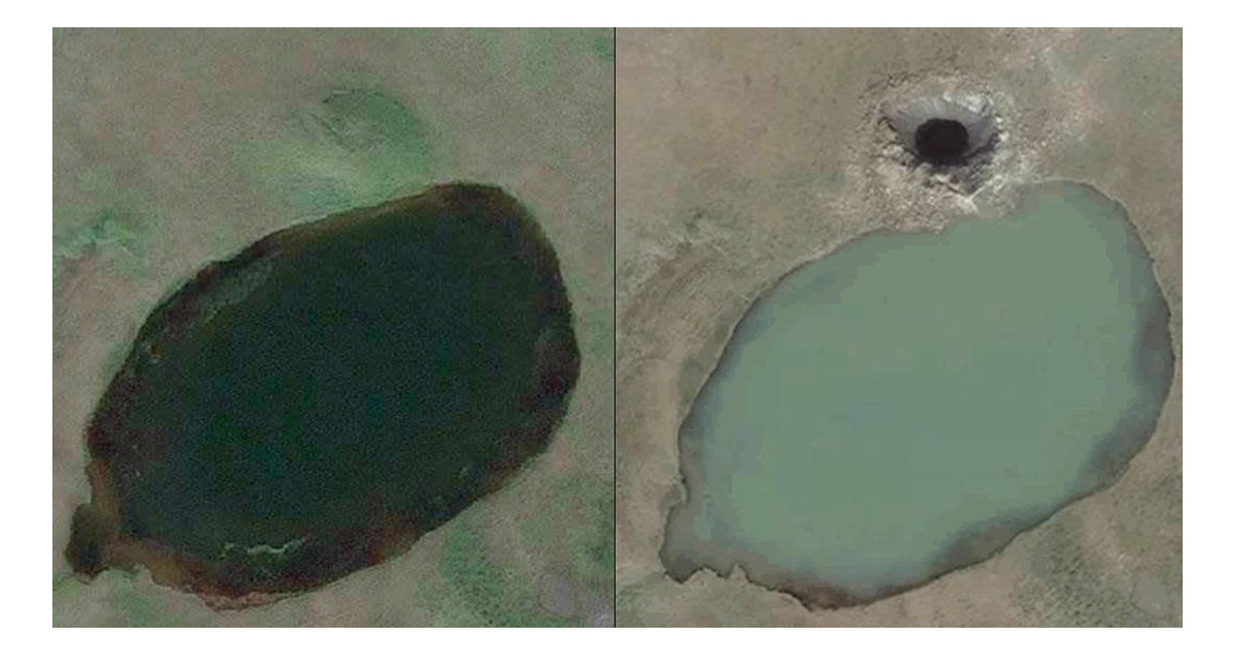
Figure 6: Satelite images before and after the formation of C4 crater on Deryabinsky area. (Left panel) 1 August 2009 versus (Right panel) 19 July 2013. Average diameter of the crater and parapet ~16m and ~33m respectively. (Source: DigitalGlobe)
Evidence of Gas Blowouts
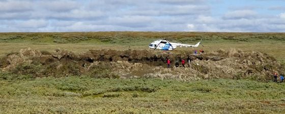
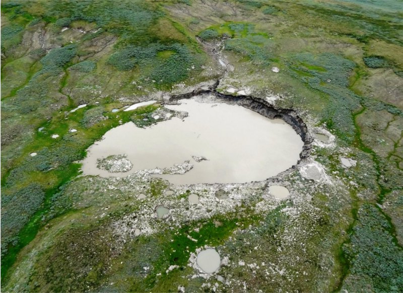 Figure 7: Horseshoe-shaped C2 crater, 8 July 2015, viewed from a helicopter. (Source: Vasily BogoyavlenskyOne of the main targets of the expedition in July, 2015 was the first investigation of the unique crater C2. This is situated 20 km to the north of C1 and 10 km south of the Bovanenkovo field. Satellite image analysis revealed that before the crater formed there was a frost mound, as there had been for C1, C3 and C4 [3, 6]. I have concluded that several gas blowouts of different power were involved to form one large (100 x 50m) lake and more than 35 smaller ones. By looking at satellite images we think that the blowout occurred between 17 July and 23 October 2012. The photo of C2 in Figure 7 proves the presence of lots of little ponds around the big irregularly shaped lake. It is obvious that the lake has expanded substantially and changed its shape mainly because of the strong thermal denudation.
Large rock fragments are scattered up to 350m around the crater. According to the satellite image and ground observations we believe there was a mud blowout or fountain, which changed much of the land around the crater. Moreover, there are well preserved parapets around the smaller lakes, 0.5–1.5m deep and up to 8m across (Figure 8). There are other possible causes for parapet formation, such as frozen rock pressure or hard parts of ice soil falling from the frost mound during the blowout.
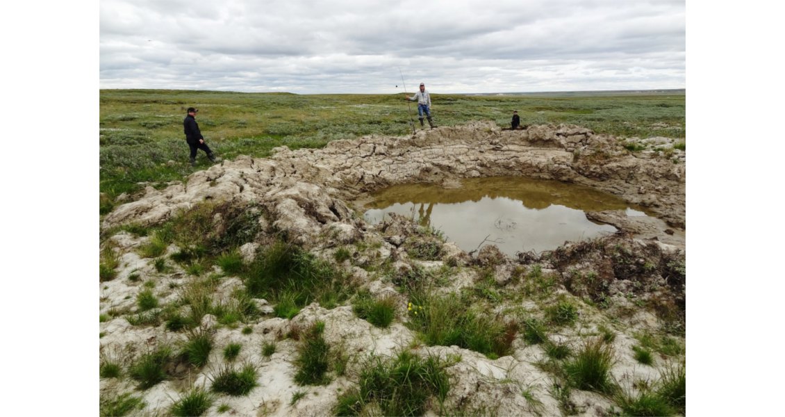
Figure 8. One of the little lakes near the C2 crater, 8 July 2015 (Source: Vasily Bogoyavlensky)
The horseshoe-shaped northern side of C2’s lake has steep, 7.5m high sides, formed from the remnant of the former pingo, in the lower part of which ice with numerous cracks is clearly seen (Figure 9). The ice is thickest in the middle of the horseshoe, the top of it lying 1–3m below ground level, while the lower border is below the water surface, as evidenced by the ice caps which formed as the underwater ice melted rapidly in relatively warm water (about 8–9°C). The western end of the steep shore is cut by a narrow ravine with vertical walls about 2.5m high, possibly the surface appearance of a deeper fault, the presence of which was confirmed by regional geophysical surveys [1, 2]. Furthermore, craters C1 and C2 are situated in the anomalously high Earth’s heat flow zone, which can provide more intense gas migration and even gas emissions or blowouts through the permafrost on the bottom of lakes, rivers and former lakes.
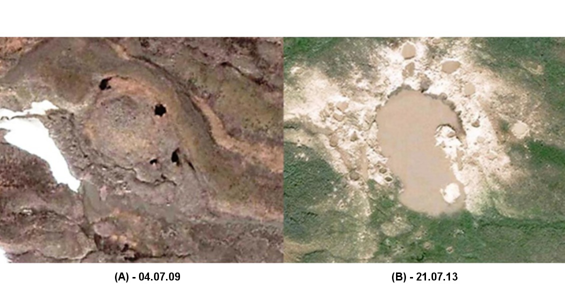
Figure 9: Satellite images of C2 object near Bovanenkovo, (A) before and (B) after the gas blowout (DigitalGlobe 4.07.09 and 21.07.13).
Some of the round lakes investigated during the 2014– 2015 expeditions proved to be just the remnants of former pingos formed while the ice cores melted. Some of the lakes, however, have banks covered with light rocks, in contrast to the surrounding vegetation. These are thought to be material, possibly loam, formed by pneumatic pingo explosions.
Satellite image analysis and visual observation from the helicopter revealed lots of round underwater depressions (pockmarks, gas springs) in many lakes of all sizes, suggesting they are a result of degasification. In one of the lakes in the North Tambey area hundreds of pockmark-like craters with parapets around them can be seen (Figure 10). Several articles about pockmarks are given in the reference list, including I. Kuzin (1992) [10], who concluded that the isotopic composition of helium and carbon in methane in the lakes proves that the gas originates at significant depths, probably from 1 to 3 km. We, however, believe that additionally to catagenic (deep) gas in many cases the released gas is biogenic, or formed as a result of dissociation of gas hydrate [12].
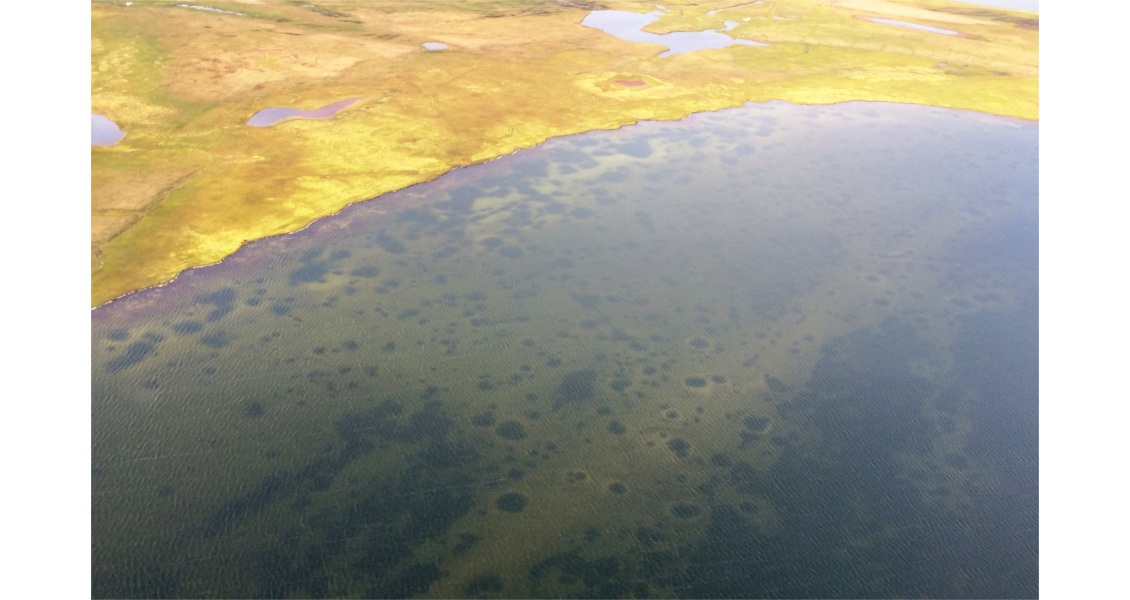
Figure 10: The lake in the North Tambey area showing gas blowout craters, 17 August 2015, viewed from helicopter. (Source: Vasily Bogoyavlensky)
Further Study Required
Through research on these craters we have concluded that there is no doubt that gas blowouts from the interior of the earth form ground and underwater craters and pockmarks as seen in the study area and many other Arctic regions. These are not unusual phenomena, but they have yet to be studied properly. We expect that many more of these and other unique natural objects formed by degasification will be discovered shortly as research intensifies in the Arctic and there is a need to undertake wider geophysical surveys to prove the natural occurrence of these objects.
It has also been observed that these blowout craters can be transformed into common lakes in a short period of time (probably just two to three years), which complicates their detection.
The local Arctic seismic monitoring network will help to determine low amplitude earthquakes connected to large gas blowouts. We hope that stations transmitting this data in real time to the Geophysical Centre of the Russian Academy of Sciences will soon appear in the YaNAO region, which will help to better study the Arctic region.
Postscript
In early September, after this article was prepared, a new expedition in Yamal took place, and one more crater (C9) has been confirmed to the south of the Bovanenkovo field.