Exciting opportunities and new play concepts
The underexplored Foz do Amazonas Basin has huge potential, revealed through integrating seismic and CSEM data.
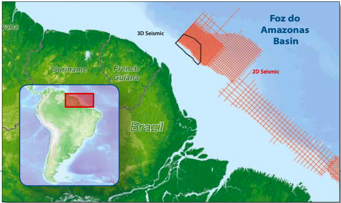
The Foz do Amazonas Basin, the most northerly of the Brazilian equatorial margin basins, covers an area of 283,000 km2, with water depths ranging from 50m to more than 3,000m. The offshore area is underexplored, especially in the deepwater setting where only two wells have been drilled in the Amazon Cone. Past exploration drilling has therefore been confined to the shelf. The ANP 11th Round presentation quoted in-place volumes of 14 Bbo and 40 Tcf gas, demonstrating huge hydrocarbon potential.
Exploration
The 11th Licence Round exploration focused on the potentially large reserves predicted in distal, Late Cretaceous/Palaeogene deepwater turbidite plays, encouraged by successful wells in neighbouring French Guiana. The plays include the Late Cretaceous deepwater turbidite fans (Zaedyus discovery) that have Cenomanian-Turonian reservoirs and similar age source rocks. In addition, the Apto-Albian has indicated oil shows in the underlying Paleocene turbidite fans in the Zaedyus appraisal well. The Zaedyus announcement reported 72m of net oil pay in two turbidite fans. The Foz do Amazonas area has recorded marine carbonate biomarkers which are also present in the conjugate margin of Sierra Leone and Liberia. The biomarkers are thought to represent the Cenomanian Turonian carbonate shales which have produced the Venus, Mercury and Jupiter discoveries.
To date, the main exploration targets have been slope channel deposits as in French Guiana. This has proven to be a challenging play with several disappointing appraisal wells due to the play not being fully understood; however, the concept still contains huge potential.
Geological Overview
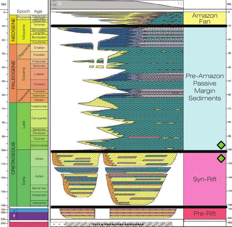
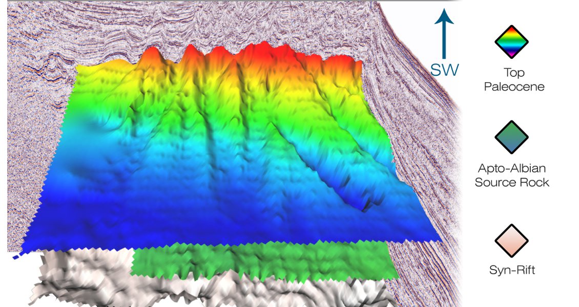
General stratigraphy Foz do Amazonas, adapted from ANP 11th Big Round 2013.The development of the Foz do Amazonas Basin began in the Triassic through rifting which resulted in the opening of the Equatorial Atlantic Ocean. In the Early Cretaceous, a second period of extension was followed by the Aptian-Albian sea floor spreading, which resulted in the formation of the South Central Atlantic. The basin is divided into the Para and Amapa platforms, the Tertiary carbonate platform and the Amazon Cone (Mello et al., 2001). The Foz do Amazonas Basin was exposed to both orthogonal and oblique extensional stress during the first rift episode and several graben systems developed, which were later filled with syn-rift sediments. The uppermost Albian shallow marine sediments may have been deposited first and then onlapped by transgressive marine shales and sandstones during the Cenomanian-Turonian. It is thought that this area has a maximum thickness of approximately 6,000m (Silva et al., 1999). These infill rift sediments are comprised of continental to marine shales and sandstones of the Cacipóre Formation.
The Amazon drainage system, which developed during the Tortonian, had profound influence on the region and continues to dominate in the present day. The Amazon Cone consists mostly of mud and isolated Mio-Pliocene sands, which are estimated to have high porosity and are the main targets for exploration. To the north of the Amazon Cone the main reservoir targets are the Upper Cretaceous and Palaeogene age clastic sediments.
Petroleum Potential
In the shallow water shelfal area of Foz do Amazonas, proven source rocks of both Aptian and Cenomanian-Turonian (Limoerio Formation) age have been identified. In wells 1 APS 0018 AP and 1 APS 0049 AP Aptian Codo Formation lacustrine source rocks (Type I) were found, with TOC of up to 10%. The shallow water shelf well, APS 29 AP, is perhaps the most interesting as it discovered oil and gas-prone Cenomanian-Turonian source rocks with Type II marine type organic matter and TOC measurements up to 3.5%.
The main reservoir targets on strike to the north-west and south-east of the Amazon Cone are Upper Cretaceous sandstones, with secondary Tertiary sandstones, as proven by the 1 APS 0045B AP well. Cretaceous to Early Paleocene shelfal sands have been drilled in well 1 APS 0045B AP, proving the presence of a shallow water clastic sand system that may have fed deeper water turbidites and fans.
Seismic interpretation has indicated a potential regional Late Cretaceous seal over the majority of the basin. The main risk for stratigraphic traps is likely to be an updip seal. There is a substantial Tertiary canyon system which could break the Upper Cretaceous shale and erode into the reservoir horizon, opening up migration routes from the Cretaceous source rocks into the Paleocene with potential clastic and mixed clastic carbonate deposition. However, research has also indicated the canyons are infilled with mud, de-risking top seal integrity for some Late Cretaceous plays.
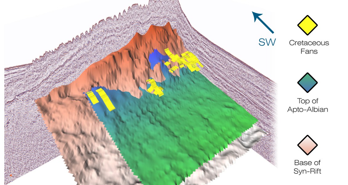
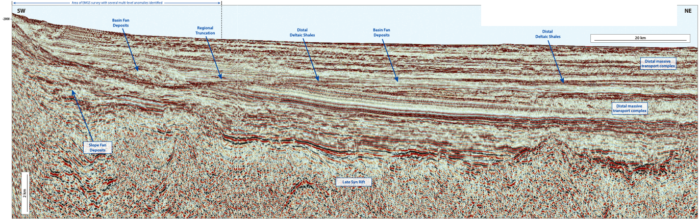
Seismic interpretation offshore Foz do Amazonas shows a steep shelf edge with an unstable slope, which may have periodically failed, resulting in mass transport and turbidites along the slope section. These debris flows can be recognised on the seismic, particularly in the Tertiary and Cretaceous sections, as high acoustic impedance slumped facies. Other features clearly imaged are incised deepwater channels and canyons which extend from the shelfal area into the deeper basin. In certain areas these canyons are over 300m deep. A number of low stands are recognised in the Cenomanian-Turonian and Campanian to Maastrichtian, when sands may have been transported via the slope channel systems into the deeper water areas of the basin. The basin floor fans have the capacity to contain significant hydrocarbon volumes.
Leads De-Risked
To complement Spectrum’s seismic data, EMGS conducted a ~4,500 km2 3D Controlled Source Electro Magnetic (CSEM) survey with the primary aim of identifying the lithology of the canyon fill and to characterise the source of the resistive anomalies in the dataset using seismic attributes, seismic facies distribution, stacking velocities and angle stacks. The results of the co-rendering work provide an important exploration tool to aid the de-risking of exploration leads in the Foz do Amazonas. The high quality seismic in both time and depth has uncovered many new and exciting opportunities. The structural geometries have been enhanced through depth migration and new play concepts have been recognised. The CSEM study combined with this seismic interpretation, plus gravity and magnetics, has identified several exciting opportunities in a relatively unexplored basin and developed new play models in the deepwater unlicensed areas.
Acknowledgements
Spectrum would like to thank EMGS ASA for their collaboration and contribution.


