An under-explored wonder, tucked far away in the middle of nowhere in the North Atlantic Ocean.
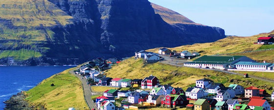
Far away in the middle of nowhere in the North Atlantic Ocean you find the Faroe Islands: eighteen small, elongated islands towering above the sea, separated by narrow sounds.
Photo credit: Bernard Cooper
There is a good reason why the Faroe Islands are called Europe’s best kept secret. The islands, lying north of Scotland and west of Norway, are so small that they are all too often missing on world maps and even on regional maps of Europe. Yet it seems the rumour is spreading, and growing numbers of people are finding their way to the Faroe Islands to explore their scenic landscapes and unique culture.
The first challenge anyone who wants to hike in the Faroese hillsides and mountains has to overcome is the ever-changing weather. The islands are located where oceanic temperate and polar air meet, and this leads to constant passages of weather fronts bringing sun, rain, fog, snow, wind and calm weather. Sometimes it feels like you have all four seasons within a day, reminding you of Mark Twain: “If you don’t like the weather now, just wait a few minutes.” The sound advice before going on adventures in the Faroese hillsides is to take good account of the weather, bring clothes for rain and wind and be careful if you run into fog or any other unforeseen challenge.
Rich Landscape of Stories
The two rock stacks north of Eysturoy – all that remains of two giant trolls. Photo credit: Bernard Cooper
The cultural heritage of the islands is rich and reflects close bonds with nature. You find that every place and even rock has its own name and, as mysterious tufts of fog crawl over the hillside, legends come alive. It is easy to listen to the stories which tell us that Fugloy is a floating island and the rocking boulders in Oyndarfjørður were pirate boats. The villages of Eiði and Tjørnuvík treasure the legend about the two giant trolls who tried to move the Faroes to Iceland. They collected the islands and began to walk into the sea, whereupon the sun rose and turned the trolls into the two tall rock stacks that can be seen in the area today.
The islands were spared, but the legend brings us to the geological origin of the Faroe Islands, which began with the same rifting plates that are in the process of forming Iceland today.
The landscapes of the Faroe Islands, from the cliffs facing the ocean, to the mountains and valleys, tell geological stories spanning giant volcanism and the opening of an ocean, followed by glacial erosion in high arctic climates and a steady attrition by North Atlantic waves. The Faroe Islands are indeed a fascinating destination for geotourists interested in the stories that natural landscapes are able to tell.
Volcanoes, Forests and a New Ocean
The picturesque village of Fámjin is located on the western side of the southernmost island, Suðuroy. On the coast close to Fámjin is a high vertical cliff formed from the Beinisvørð Formation, which gives us a window into the early geological history of the Faroe Islands about 60 to 55 million years ago, when the opening of this part of the North Atlantic Ocean was in its infancy. At this time the land areas of what is now the Faroe Islands and eastern Greenland were still joined.
Volcanic eruptions developed along a long rift close to the present coast of east Greenland as the North American and Eurasian plates began to drift apart. This type of volcanic activity is found all over the world where two tectonic plates move away from each other, but this time there was a difference. In one particular area along the new rift zone the flood basalt eruptions resulting from the volcanic activity reached an epic scale and huge amounts of basaltic magma poured out of volcanic rifts and flowed many tens of kilometres over the landscapes. The long parallel layers that we can see in the cliff at Fámjin are basaltic sheet flows, each horizon a former land surface showing how flat these vast volcanic fields were.
The majestic cliffs at Fámjin were built by a series of basalt flows in the Paleocene. Photo credit: Lis Mortensen
The cliff reveals the magnitude of the early basalt flow eruptions that formed the Faroe Islands. Basalt flows formed by volcanic eruptions during this late pre-breakup period elsewhere usually reach a thickness of 10 to 30m; the thickest basalt horizon found in the coastal cliff of Fámjin is 70m thick. Is it possible to even imagine the sheer scale of an eruption from a volcanic rift producing a lava stream of such magnitude which also covered a vast area of land?
The red sedimentary rock seen separating the basalt horizons in the cliffs at Fámjin shows that nature reverted to a subtropical climate during the pauses between volcanic eruptions. The barren lava fields were repeatedly transformed when soil developed in the ash-rich ground, and forests with metasequioa and other subtropical tree species colonised the flat landscapes. The cycle repeated itself with the next volcanic eruption when once again huge quantities of basaltic magma erupted from the rift zone and thick lava streams ran over the landscapes, burying the forests.
The Beinisvørð formation exemplified in the coastal cliff at Fámjin shows the character of the huge flood basalt eruptions in the period before the rift opened. After the opening there was a long pause in volcanic eruptions and the young Atlantic Ocean began flowing between Greenland and the Faroese land plateau. Subtropical forests took over the landscapes and thick layers of dead wood and other organic waste material built up in wet basins, eventually forming the coal of the Prestfjall Formation. Although the coal is not of the best quality, it was a valuable resource which was exploited for centuries and a coal mine is still open in Hvalba on Suðuroy today.
The Last Days of the Volcanoes
After a long pause, volcanic activity began again with a huge explosion, evidence for which can be observed in the Hvannhaga Formation, best seen in the beautiful valley of Hvannhagi, again on the island of Suðuroy. The volcanic eruptions continued with the build-up of the Malinstindur Formation, which comprises a continuous series of basalt eruptions with practically no breaks.
By this time the rift between Greenland and the Faroese land plateau had opened and a new mid ocean ridge began to take shape between the coasts of the two land areas. The twin landscapes of the Beinisvørð Formation in Greenland and the Faroese land plateau were separated forever.
Evidence of the effect of volcanic activity on the new low-lying land can be observed in the area around the village of Vestmanna on Streymoy, the largest of the northern group of islands. A boat ride to the majestic cliffs of Vestmannabjørgini on the west coast of Vestmanna allows a closer look at the volcanic eruptions which occurred in conjunction with the opening of a young world ocean. The eruptions were smaller than previously but much more frequent, with few pauses between them, so the whole basalt series of the Malinstindur Formation seems to be welded together without any weak sedimentary rock horizons.
A hole in the basalt left after a tree caught in the lava flow burned away but cooled the hot lava so much that it solidified, leaving the shape of the burned tree forever frozen into the basalt. Note the layer of red sediment beneath the lava. Photo credit: Jens Kjeld Jensen
The upper basalt series of the Faroe Islands is the Enni Formation, which was deposited when the volcanic eruptions once again changed character to somewhat larger flood basalt events. These basalt flows could reach a thickness of a few metres and are frequently separated by thin sedimentary rock horizons, which tells us that there were pauses between the volcanic events again, as the soil had time to develop and create the environment suitable for subtropical forests to colonise the flat landscapes.
A good place to look at the last days of the volcanoes that built the Faroe Islands is on Nólsoy, a small island just to the east of the capital, Tórshavn. The basalt horizons are once again clearly visible, separated by soft reddish sedimentary rock horizons in the layered appearance of the mountains so characteristic of the Faroese landscape. East of the village of Nólsoy there is an interesting locality with a calling card from the subtropical forest: a horizontal hole in the shape of a large tree trunk, which is thought to have been caused when a tree was caught in a lava flow. Its foot would have caught fire so the whole tree fell and was consumed into the lava. The line of the tree probably points towards the flow.
Out of Fire, into Ice
The volcanic activity that built the Faroe Islands eventually died down as the part of the Eurasian plate with Faroese land area moved out of the active volcanic rift zone. Land construction was complete – and the destruction phase took over. At the same time the subtropical climate of the area gradually cooled over the next 40–50 million years, during of the Paleogene and Neogene Periods.
The beginning of the Quaternary Period 2.6 million Placeholder years ago brought severe climate fluctuations. The Earth experienced ice ages during which the middle to high latitudes were subjected to high arctic conditions, interspersed by shorter interglacial periods with warmer climates similar to those we are experiencing at the moment. In the Faroe Islands erosion during the ice ages completely transformed the scenery as the landscape of flat low relief suffered severe glacial erosion, which formed deep valleys, steep mountain slopes and narrow fjords and sounds.
The fiord of Kollafjørður on the island of Streymoy is a classic glaciated valley, surrounded by flat layered basalts. Photo credit: Óluva Eidesgaard
A classic place to observe the severe transformation of the Faroese landscapes shaped by glacial erosion is along the high mountain road above Kollafjørður, about 20 km north of Tórshavn. Looking down the mountain slopes above the fjord we see the basalt layers on both sides of the fjord and, with some effort, we can pair the horizons across the fjord and realise how flat the landscape used to be. The glacial erosion during the quaternary period has irreversibly transformed the low relief area of Kollafjørður into a classic U-shaped valley with steep mountain slopes and a wide valley floor.
Destruction by Ocean Breakers
Stories about gigantic volcanic eruptions and extensive glacial erosion are the geological heritage of the past. These are not active forces today, but are forever moulded into the landscapes of the Faroe Islands.
The most active force shaping the islands today is the ocean and the destruction of the coast by strong storm breakers. Every year the ocean eats into the land and the steep coastal cliffs facing the ocean pay the highest toll.
The waterfall at Bøsdalafossur, which drains Sørvágsvatn, seen on the front cover. For scale, note the people near the top of the waterfall. Photo credit: Lis Mortensen
The waterfall at Bøsdalafossur, which drains Sørvágsvatn, seen on the front cover. For scale, note the people near the top of the waterfall. Photo credit: Lis Mortensen
A breathtaking place to watch the erosion caused by the sea is near Bøsdalafossur waterfall at the end of Lake Sørvágsvatn on the western island of Vágar. The area around the lake is mild and friendly until the path brings you close to Bøsdalafossur, where the water suddenly drops into the sea via a 30m high waterfall. The whole area around the waterfall is a vertical cliff which is constantly shedding pieces of rock into the ocean below.
The Faroe Islands may not last forever and we can let a place like Bøsdalafossur remind us of the importance of enjoying and caring for nature as it steadily changes around us.
Other reads…
Into the ‘White Zone’: Exploration in the North-West Atlantic Margin by Jane Whaley
Faroe Islands: Success Near by Jane Whaley


