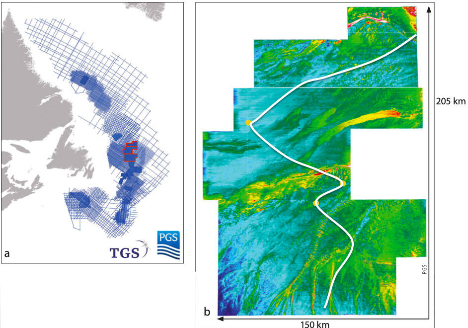
the modern day depositional directions. The white line shows the track of the 2D seismic section below.
Exploring the highly prospective Orphan Basin
Eastern Canada is one of the most promising deepwater exploration areas in the world, where the implementation of state-of-the-art imaging technology is critical to develop a more detailed local subsurface understanding.
First oil in the Jeanne d’Arc Basin was produced in 1997 from the Hibernia Field and since then the world-class oil-producing fields Terra Nova, White Rose and North Amethyst have come onstream, while oil production from the Hebron Field started in 2017. The Mesozoic basins of Grand Banks alone are estimated to hold recoverable reserves of 4.6 Bbo and 18.8 Tcf of natural gas. The 2009 Mizzen oil discovery in the Flemish Pass Basin, estimated at 200 MMbo recoverable reserves, proved the extension of a working petroleum system, sourced by the prolific late Jurassic source rock, into an area where it was previously untested. This was followed in 2013 by Harpoon and Bay du Nord fields. The Bay de Verde appraisal of Bay du Nord was successful in 2015 as was the Baccalieu discovery in the same area in 2016.
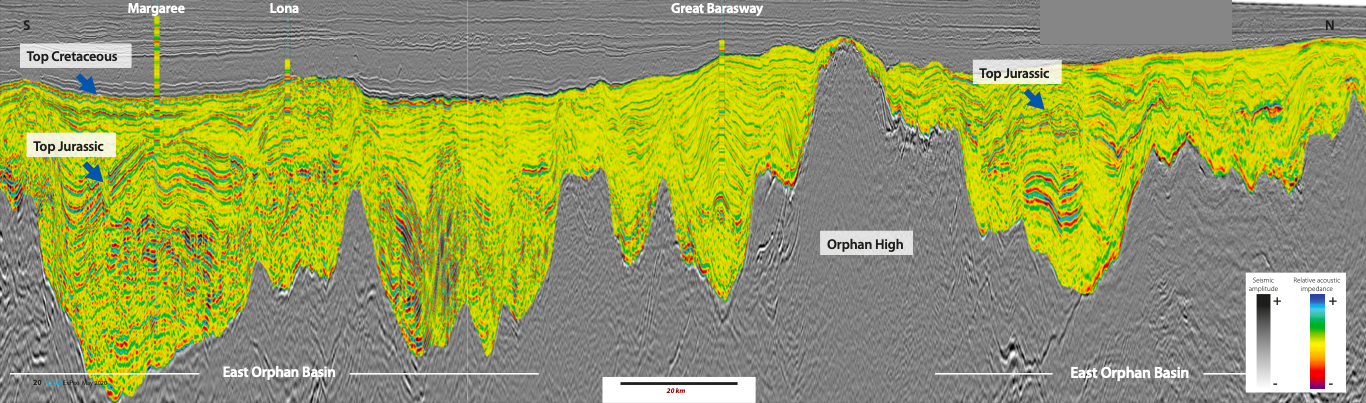
PGS, in partnership with TGS, have been acquiring 2D and 3D GeoStreamer MultiClient data in Newfoundland and Labrador since 2011. The extensive library offshore eastern Canada and the seismic-based geological products for Newfoundland and Labrador are comprehensive. Now this library also includes the contiguous Long Range, Tablelands and North Tablelands surveys in the Orphan Basin (Figure 1). The seismic data shown in the foldout (Figure 2) from Long Range in the south to North Tablelands in the north demonstrates the numerous horsts and grabens present in this part of the Orphan Basin. The existing fields and discoveries are often drilled into rotated fault blocks in the older section and are adjacent to tilted half grabens and this line indicates multiple opportunities for prospective traps for the industry to test. The 3D data delineates play fairways from the Orphan Basin in the north to the Jeanne d’Arc Basin in the south while the 2D data is available for regional interpretation and basin analysis.
Open acreage in prospective basins
Eastern Canada is one of the most promising deepwater exploration areas in the world. In addition to the producing basins of East Canada, there are also some highly prospective underexplored basins such as the Orphan Basin with potential for exciting new discoveries and world-class oil production. Access to new acreage, transparent fiscal terms and a predictable land-sale policy make East Canada an attractive region for oil and gas exploration.
Exploration targets include Late Jurassic to Early Cretaceous fluvial to shallow marine sandstone reservoirs sourced by prolific oil-prone Late Jurassic marine shales. A mainly extensional margin provides large structural traps and thick regional seals. Potential reservoirs from Lower Cretaceous to Lower Tertiary are stratigraphically positioned above the Kimmeridgian source rock super highway.
GeoStreamer broadband data reveals a well-defined rift section and high fidelity pre-stack seismic attributes in the Tertiary section make identifying stratigraphy and possible fluid effects easy. Work over the three datasets using pre-stack relative inversion has demonstrated fan geometries in the younger section of the Orphan basin and the northern portion of the Flemish Pass basin.
Advanced tools image complex geology
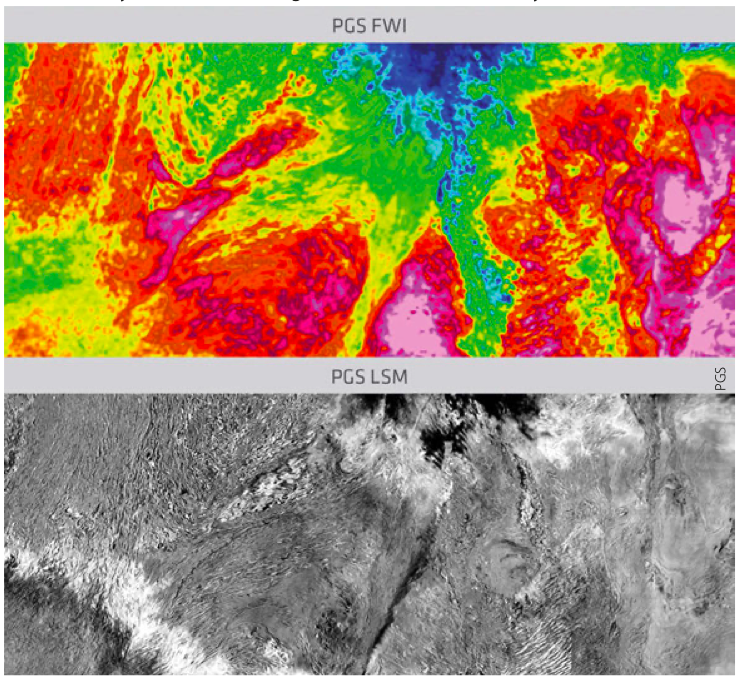
In addition to the regional imaging effort over this very large dataset, the implementation of state-of-the-art imaging technology is critical to develop a more detailed local subsurface understanding. Full waveform inversion (FWI) and least-squares migration (LSM) use the extra-broad frequency range recorded in the GeoStreamer data to better estimate a detailed velocity field and produce a robust image of the subsurface. In combination, they can minimize drilling risks and aid reservoir understanding (Figure 3).
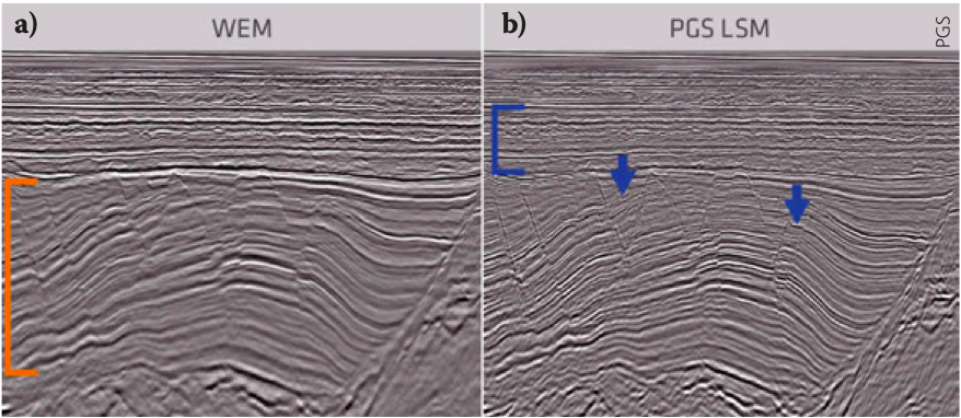
Depth migration techniques have been widely used in areas with strong lateral velocity variation. Though very robust, traditional depth imaging methods suffer from acquisition and propagation effects that limit resolution and impact the amplitudes in the resulting seismic images. LSM is an emerging new imaging technique that compensates for acquisition limitations and variable illumination, and provides more reliable amplitude information in particular in areas of high structural complexity. In Tablelands, a data-domain LSM approach was selected to improve the vertical-seismic image resolution and enhance the fault definition especially in the syn-rift section (Figure 4).
Rapid prospectivity screening in the Orphan Basin
To facilitate a more rapid assessment of subsurface prospectivity potential, a fast-track image was delivered for North Tablelands together with QI products for interpretation and integration with pre-stack broadband attributes. Turnaround time was significantly reduced by integrating the imaging and QI work efforts. Pre-stack AVO QC was performed during the processing to ensure that the final pre-stack data was fit for purpose and AVO/AVA compliant for further QI analysis.
improvements in the Cretaceous and Jurassic.
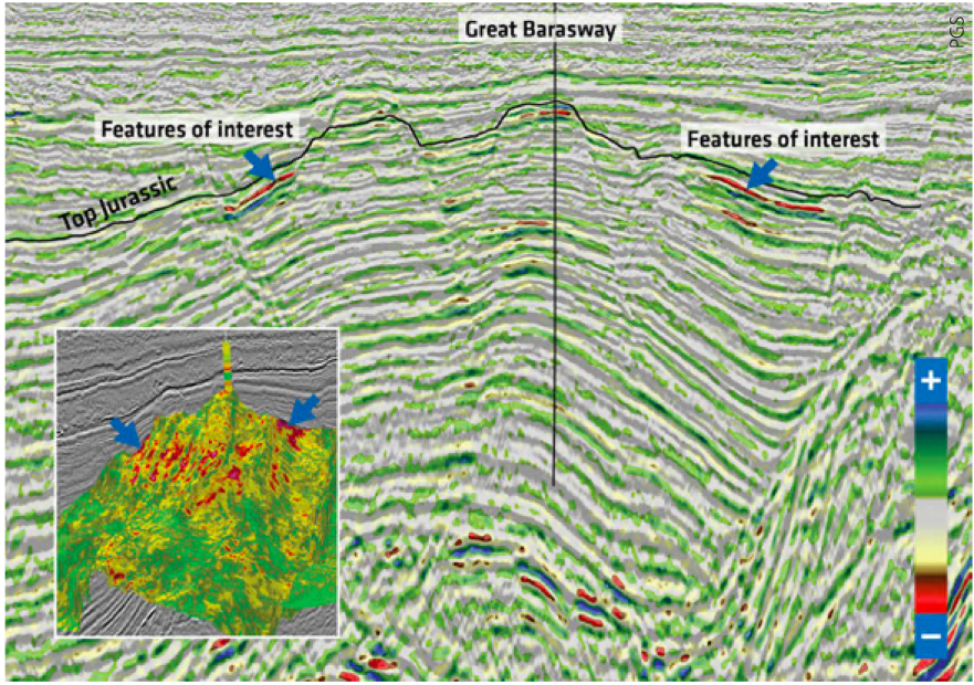
A final QI analysis including lithology and fluid prediction through a three-term AVO inversion was performed on the full integrity data from the Tablelands survey using all the available information including well log data. Three wells are present in the region of Long Range, Tablelands and North Tablelands: the Great Barasway F-66 well (drilled in 2006), Lona O-55 (drilled in 2010) and the Margaree A-49 well (drilled in 2013). These three wells drilled the main reservoir and source rock in the area. The Tithonian to Kimmeridgian interval was used to build a regional rock physics model. The Great Barasway well was modeled and has a good tie to the source rock and high quality siliciclastic reservoirs.
Relative Vp/Vs overlaid on the pre-stack seismic (Figure 5) around the Great Barasway well reveals some interesting AVO anomalies characterized by very low relative Vp/Vs values on the flank of the main structure. Based on the rockphysics work, low relative Vp/Vs could indicate the presence of hydrocarbons. These anomalies are of reasonable size, and can be spatially tracked on the 3D inset in Figure 5 bounded by some well-imaged faults.
Rapid prospectivity evaluation in the Orphan Basin
3D GeoStreamer broadband seismic data acquired in the last three years by PGS and TGS in the Orphan Basin demonstrates how regional prospectivity scanning can be combined with a detailed local appraisal of hydrocarbon potential using the high quality pre-stack data and rock physics analysis. The use of state-of-the-art depth imaging technologies leads to better subsurface images and improved reservoir understanding. For the most recent North Tablelands survey high quality fast-track QI products were produced to aid more rapid prospectivity evaluation for ongoing and upcoming license rounds.
Further reading on seismic data from Canada by PGS
GEO ExPro
TGS and PGS recently announced a joint multi-client High Density 3D project in the Jeanne d’Arc Basin offshore Newfoundland, East Canada.
This article appeared in Vol. 16, No. 4 – 2019


