Incan civilisation arose in the Peruvian Andes in the 12th century. At its zenith in the early 1500s, the empire spanned much of western South America, from modern-day Ecuador to Argentina. At its heart lay the valley of the Urubamba River – the Sacred Valley – whose rich soils and mild climate are ideal for growing maize, making it the Incas’ breadbasket. Today, a journey through this beautiful vale offers visitors gorgeous scenery, opportunities to marvel at the Incas’ precision, earthquake-resistant stonemasonry, and tantalising glimpses of innovative ways the ancient civilisation harnessed the region’s geology.

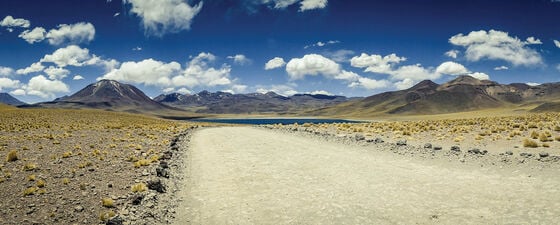
Altiplano Plateau. Source: Shutterstock.
The Cuzco area’s landscape is awe-inspiring, thanks to its location in the tectonically complex Andean subduction zone. Cuzco nestles in one of several pull-apart basins formed along the seismically active Cuzco normal fault system, located well to the east of southern Peru’s active volcanic arc. This fault system separates the northern extremity of the Altiplano Plateau from the non-volcanic Cordillera Oriental mountain chain, which has been thrust over the Brazilian Shield. The Cuzco valley stands at 3,400m elevation on the plateau; glacier-clad peaks in the adjacent Cordillera Oriental soar to 6,300m, four kilometres above the cloud forests, sustained by moisture from the nearby Amazon, that wreath the precipitous river valleys.
Peru has been a subduction zone since the Jurassic, but today’s dramatic topography only began forming about 26 million years ago as an indirect response to the consumption of the northern Farallon Plate in the California Trench. That event split the Farallon Plate’s southern reaches into today’s Cocos and Nazca Plates; the Nazca has been converging orthogonally with South America at about 11 cm per year ever since. Despite that steady convergence rate, shortening in the Peruvian Andes has fluctuated, with long periods of meagre, 1 mm per year shortening punctuated by brief but faster periods of 10–20 mm per year.
Scientists attribute these fluctuations to variations in the retreat rate (rollback) of the Nazca slab. During periods of rapid rollback, plate retreat has accounted for almost all the convergence. But during brief intervals of slow retreat, the bulk of plate convergence was instead accommodated by Andean shortening. These fluctuations explain the simultaneous presence of thrust faults in the foothills and normal faults in the High Andes and Altiplano: during times of rapid slab retreat, the body forces imposed by the region’s great height have caused gravitational collapse amidst regional compression.
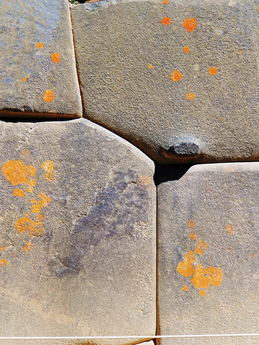
Stonework in Ollantaytambo’s Temple of the Sun. Credit: Lon Abbot and Terri Cook.
Most visitors arrive in Cuzco, but few are sufficiently acclimated to Cuzco’s 3,400m elevation to enjoy tourist forays right away. For that reason, we suggest that you begin your exploration of the Incan heartland in the 2,800m-high Ollantaytambo, which is nestled in the Sacred Valley 72 kilometres north-east of Cuzco.
The Royal Estate: Ollantaytambo
Ollantaytambo, ‘Olly’ to most visitors, occupies a strategic location where the Sacred Valley narrows dramatically as the Urubamba River passes from Mesozoic marine rocks into more erosion-resistant Palaeozoic basement. Pachacuti, founder of the Incan Empire, made Olly a royal estate. A century later, when the Spanish conquistadors overthrew the Incan Empire and took Cuzco in 1533, they installed Manco Inca Yupanqui as the puppet emperor. Mistreatment by the Spaniards caused Manco Inca to rebel in 1536. After leading a 10-month siege of Cuzco, Manco Inca retreated to his stronghold at Olly, where his army defeated 100 conquistadors and their 30,000 conscripted indigenous troops in 1537’s Battle of Ollantaytambo.
Visitors reach Olly’s pre-eminent archaeological site, the Temple of the Sun, by ascending steep staircases through stone-lined Incan agricultural terraces, passing several stone fountains. The Temple’s stonework is impeccable, with many joints between adjacent stones too tight to pass a sheet of paper between them. The Wall of Six Monoliths consists of massive pink granite slabs derived from quarries six kilometres away, on the other side of the river. It is mind-boggling to contemplate how the Inca managed to transport these huge monoliths so far.
Today Olly serves as the gateway to Machu Picchu. It is the staging area for spectacular four-day Inca Trail treks and the departure point for the 1.5-hour train trip through the deep Urubamba Gorge to Aguas Calientes, where most non-trekking tourists spend the night before touring Machu Picchu.
Machu Picchu: The Incan Magnum Opus
This world-famous archaeological treasure is the indisputable highlight of any trip to southern Peru. What really sets Machu Picchu apart is its dramatic setting. It is perched at 2,430m on a ridge connecting the 3,062m-high Machu Picchu Mountain with Huayna Picchu, the pyramidal peak that forms the ruins’ stunning backdrop in iconic photos. The Urubamba River snakes picturesquely around Huayna Picchu in a stately oxbow, 400 metres below the archaeological site. Clouds and mist frequently obscure the middle-elevation slopes of the verdant canyon walls, making Machu Picchu the definition of an ‘atmospheric’ location!
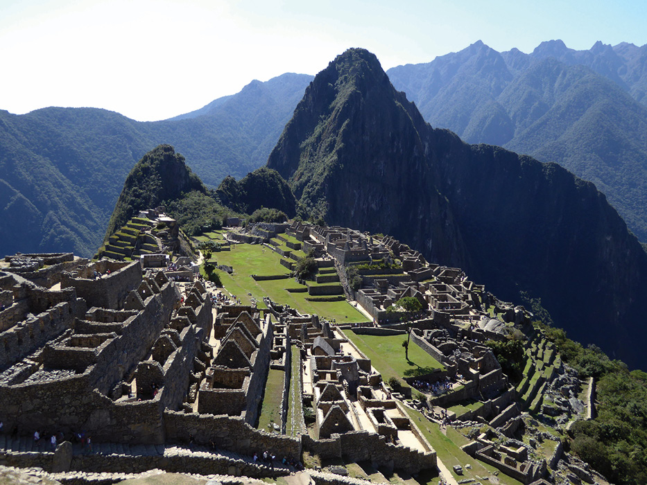
Atmospheric Machu Picchu. Credit: Lon Abbot and Terri Cook.
Inca Trail trekkers enter the site through the Sun Gate, the complex’s ancient main entrance. Those visiting by train either stay at a luxury lodge just outside the complex or take a 20-minute bus ride up from Aguas Calientes. Only day trips are allowed. The complex’s most architecturally significant features are the semi-circular Temple of the Sun, the Intihuatana Stone, and the Inti Mach’ay cave. All were religious sites dedicated to sun worship. The trapezoidal ‘Solstice’ window at the Temple of the Sun was oriented to let sunlight strike the central stone platform on the June solstice. Similarly, the pillar of the Intihuatana Stone points directly at the sun on the June solstice. Its name translates as ‘hitching post of the sun’ because the Inca believed the stone held the sun steady on its path across the sky. The exquisite stonework around the Inti Mach’ay cave was designed to channel sunshine through a tunnel-like window to strike the back of the cave for a few days surrounding the December solstice.
Recent research indicates that Incan stonemasons had a sophisticated understanding of earthquake engineering. Earthquakes occur regularly in southern Peru; a 1950 earthquake destroyed one-third of the buildings in Cuzco and damaged the Spanish-built Cuzco Cathedral. However, the building’s Incan-built foundation was nearly unscathed; only the corners of a few blocks were chipped off, and a few others slid a centimetre or two out of place. Subsequent research has shown that these are the most characteristic features of palaeo-earthquake damage, and that even this modest amount of damage to the sturdy Incan stonework occurs only when the modified Mercalli intensity reaches level VIII–IX. A 2020 study systematically examined Machu Picchu’s Temple of the Sun and another impressive edifice, the Temple of Three Windows, for such earthquake damage. The Temple of the Sun is especially amenable to palaeo-seismic study because its semi-circular construction allows detection of damage caused by waves propagating in any direction, and it facilitates discrimination between earthquake damage and damage caused by downslope creep.
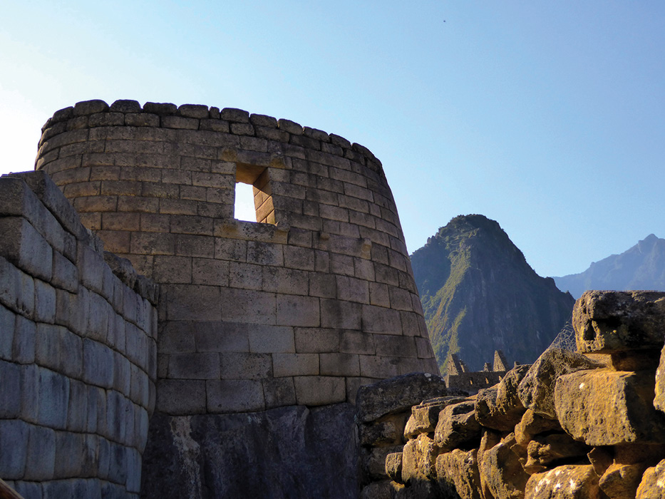
Machu Picchu’s Temple of the Sun. Credit: Lon Abbot and Terri Cook.
The study detected damage caused by two earthquakes, one whose waves propagated N20°E from a focus on an active normal fault 30 km south of Machu Picchu, and another whose waves travelled at N110°E from a similar fault that lies 20 km to the north. The researchers employed classic stratigraphic techniques to deduce that these quakes occurred during Machu Picchu’s construction (sometime between 1438–1491), noting that the lower walls’ high quality stonework exhibited earthquake damage, but the rough, simple stone construction (which characterised later work at Machu Picchu) does not. A hike up either Huayna Picchu or Machu Picchu Mountain provides panoramic views of the ruins. Huayna Picchu is a shorter, more popular hike, but we loved the climb up Machu Picchu Mountain. It provides the iconic view of Machu Picchu, framed by Huayna Picchu and the Urubamba Gorge behind. On clear days the glacial cap of 6,271m-high Salkantay, Peru’s 12th-highest mountain, looms to the south. A 15-minute detour brings you to the impressive Inca Bridge. Here an Incan road was hewn into a cliff, with a six-metre gap spanned by logs engineered into it. If enemies approached, the defenders needed only to withdraw the logs to protect the settlement.
Tapping a Mesozoic Sea: The Saltworks at Maras
The Sacred Valley holds many other worthy scenic attractions besides Machu Picchu. One of our favourites was the saltworks at Maras, 40 km north-west of Cuzco. Maras stands on a plateau high above the Urubamba Gorge. The plateau is capped by a Mesozoic marine sequence containing evaporites. After groundwater dissolves those evaporites it issues as a salty spring at the head of a small, amphitheatre-headed tributary to the Urubamba. The Inca built thousands of small, terraced evaporation ponds in the gorge to extract the salt, and today’s villagers continue the tradition.
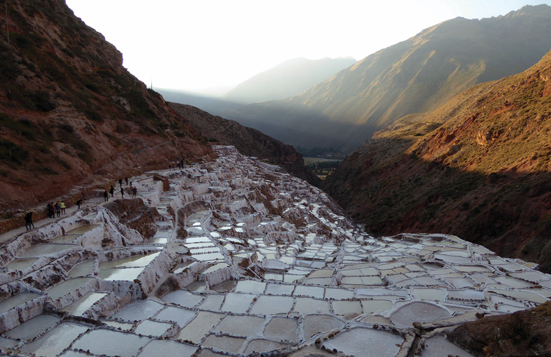
Terraced saltworks at Maras. Credit: Lon Abbot and Terri Cook.
The salt forms in three layers. The first, pink, layer consists of highest-quality table salt, the second, white, layer is ordinary bulk salt, and a grey salt-mud mixture forms the third layer, which is sold as industrial salt. The jumble of white and pink ponds juxtaposed against the steep, red and tan canyon walls dotted with scrubby vegetation is an arresting sight. We wandered delightedly through the ponds, but the local salt cooperative has since closed them because of visitor-caused contamination. You can still enjoy panoramic views of the ponds from several viewpoints on the canyon rim.
An Incan Agricultural Research Station: Moray
Moray, just a few kilometres from Maras, offers visitors a scenic stop that illustrates another way the Inca harnessed the local geology to public benefit. A series of circular sinkholes up to 30 metres deep formed here in the plateau-capping Cretaceous limestone. The Inca lined the sinkholes with terraces constructed from blocks of nearby Tertiary andesite and plumbed it with a sophisticated irrigation system. They then filled the terraces with soil imported from all parts of their empire. The sinkholes’ various aspects produce a range of temperatures that, combined with the regulation of water from the irrigation system, produced a range of microclimates in a small space. Archaeologists believe Moray served as an agricultural research station, where the viability of various crops was tested in soil types and climates spanning the empire.
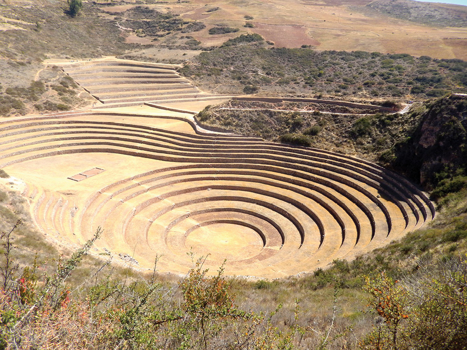
Ancient agricultural research station at Moray. Credit: Lon Abbot and Terri Cook.
Capital of the Empire: Cuzco
Cuzco, a city of 430,000 inhabitants, bustles as much today as it did when it served as the capital of the far-flung Incan Empire. It was built about 900 CE by the Killke people, who were later conquered by the Inca. The modern city’s centre, the Plaza de Armas, has served as a gathering place since Incan times. It hosts Cuzco’s top tourist attraction, the Cuzco Cathedral. In Incan times it was the Kiswarkancha palace, which was razed by the conquistadors when they took control of the city in 1533. They built the cathedral on the Incan foundation, constructing it from andesite blocks they scavenged from Saqsaywaman, an Incan citadel that stands atop a hill overlooking the city.
The Cathedral is an impressive example of Spanish colonial architecture, and houses important historical artefacts, including the ‘Christ of the Earthquakes’, a wooden crucifix blackened by years of candle smoke that is paraded every year during Holy Week to commemorate the devastation wrought by the 1650 earthquake. The museum also hosts important works painted by the ‘Cuzco School’ of art, which the Spanish colonists founded to teach European-style art to the indigenous Quechua. The oldest painting, the ‘Señor de los Temblores’, depicts townspeople parading the Christ of the Earthquakes around the Plaza de Armas during the 1650 earthquake as they prayed for the shaking to end. Another important, and humorous to Western eyes, painting depicts the Last Supper, with Christ and the Disciples dining on roasted guinea pig, a local delicacy.
Like all visitors to Cuzco and the Sacred Valley, geologists will revel in the area’s scenic grandeur and admire the Inca’s incomparable stonemasonry. But they will likely get a wee bit extra satisfaction from the journey, thanks to their comprehension of the geologic forces that sculpted the landscape and their appreciation for the geologic acumen displayed by the Inca.


