
New prospects generated in the Norsel High
The new-found prospectivity in the Norsel High rejuvenates the established oil and gas plays of the Norwegian Barents Sea.
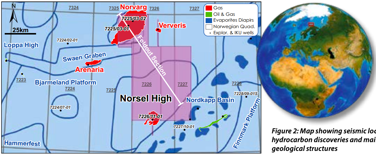
Following the drilling of the first well on the Norsel High (7226/11-01) in the 1980s, this area has been overlooked for more than two decades, despite the discovery of gas in the Havert Formation. Over twenty years later, wells 7225/03-01 and -02 found multiple gas zones at the top of the Norvarg Dome, in the Stø, Snadd and Kobbe Formations (Figure 1). The drilling campaigns did not resolve the full extent of these accumulations. Discoveries in the surrounding area include the Ververis and Arenaria wells, where Ververis proved gas in Middle Triassic sandstone, although the gas-water contact was never found.
Geological evolution of the Norsel High
That first well on the Norsel High (7226/11-01; see Figure 2 for location) penetrated the deep stratigraphic section of the Barents Sea, into the Permian-Carboniferous limestones and evaporites (see Figure 3). A basement high was confirmed to have been present since the Devonian, which had maintained its relief during the Carniferous and the Permian, llowing several carbonate sequences to develop as build-ups. These eventually grew laterally as carbonate platforms, and are now horizontally juxtaposed against salt deposits and diapirs, such as those observed in the adjacent basin (e.g. Nordkapp to the east). Carbonate platform growth continued into the Triassic, when they were replaced by deposition of up to 2,500m of clastic sequences.
Depth conversion and isopach generation from 3D seismic suggests that differential compaction in the Lower Triassic shale (Havert Formation) preserved the gentle positive topography of the Norsel High during the Lower and Middle Triassic, before it was finally overlain by a few tens of metres of Jurassic and 1,000–1,500m of Lower Cretaceous sediment.
During the Upper Cretaceous to Paleogene, tectonics reactivated the pre-existing fault-boundary with the Nordkapp Basin and inverted the pelagic area to the north, forming the Norvarg Dome.
Source rocks and maturity
The Norsel High exhibits proven hydrocarbon systems, regionally present in the Barents Sea and distributed at multiple stratigraphic levels from the Permian- Carboniferous to the Triassic and the Jurassic.
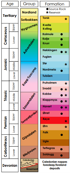
Oil and gas prone sources have been mapped in the Gipsdalend and Tempelfjorden Groups, which are particularly thick in Nordkapp and under the Norvarg Dome. These source rocks have been buried below 3,000m since the Jurassic and are likely to be in the gas window since the Cretaceous (Henriksen, 2012) (Figure 1).
Numerous proven source rocks are present in the Triassic, characterised by shale and coal beds. As well as being demonstrated to be gas-prone, these have also been proved to be oil-prone source rocks, and have gained even more interest since the discovery of oil in the area of Wisting to the north. Triassic source rocks are present at various depths (Figure 1), and these have different maturities (Ostanin et al., 2017). The point of expulsion is complex to model, as oil and gas windows may have moved upward through time, despite the lack of subsidence in the Jurassic and the limited Cretaceous-Paleogene uplift. For this reason oil may have migrated to plays and traps at several different times.
Reservoirs and prospectivity
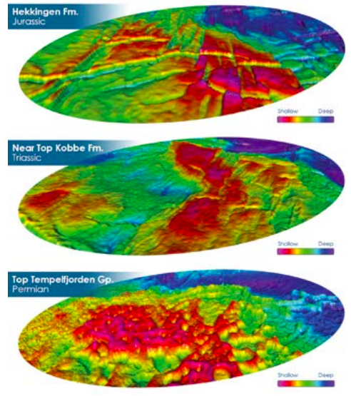
The new 3D seismic has allowed the generation of a number of hydrocarbon prospects in various structural traps in both Jurassic and Triassic targets (see Figure 4). The broadband imaging was vital to jointly map the channels and the structural closures. The prospects generated measure tens of square kilometres and have been confirmed by depth conversion.
Additional closures are still well preserved at the Top Permian and at the boundaries of the carbonate sequences. These deeper structures may have hosted the earliest hydrocarbons generated, which eventually re-migrated into younger prospects nearby (Figures 4 and 5).
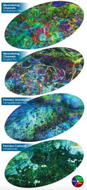
The Jurassic and Triassic sandstones have been confirmed as the main targets for exploration. Channels and stratigraphic patterns are less faulted and easier to map on the Norsel High when compared to the Norvarg Dome, giving better control on reservoir distribution. Meandering channels have been mapped in the Snadd and Fruholmen Formations (see Figure 5), the channels being approximately 100–150m in thickness and demonstrating a clear meandering geometry.
Regional seals are provided at Top Jurassic by the Hekkingen Formation, while Triassic reservoirs can rely on a number of intra-formational shales for trap seal.
New prospects confirmed in the Norwegian Barents Sea
Spectrum’s 3D seismic, broadband processed, enables the imaging of reservoir distribution and reservoir connectivity, and allows the reassessment of the hydrocarbon resources, both oil and gas, in the Norsel High area. New prospects have been generated, potentially charged by liquid hydrocarbons from multiple phases of expulsion and migration. Oil legs below gas are considered likely either due to incomplete flushing of early oil or remigration from older deeper structures.
References
Henriksen, E., Bjørnseth, H.M., Hals, T.K., Heide T., Kiryukhina, T., Kløvjan, O.S., Larssen, G.B., Ryseth, E., Rønning, K., Sollid, K. and Stoupakova, A. (2012). Uplift and erosion of the greater Barents Sea: impact on prospectivity and petroleum systems. Geological Society, London, Memoirs, 35, 271-281.
Ostanin, I., Anka, Z., and Di Primio, R. (2017). Role of Faults in Hydrocarbon leakage in the Hammerfest Basin, SW Barents Sea: insights from seismic data and numerical modelling. Geosciences, 7, 1-30.


