Blue skies over Malabo
Time for Equatorial Guinea’s next day in the sun
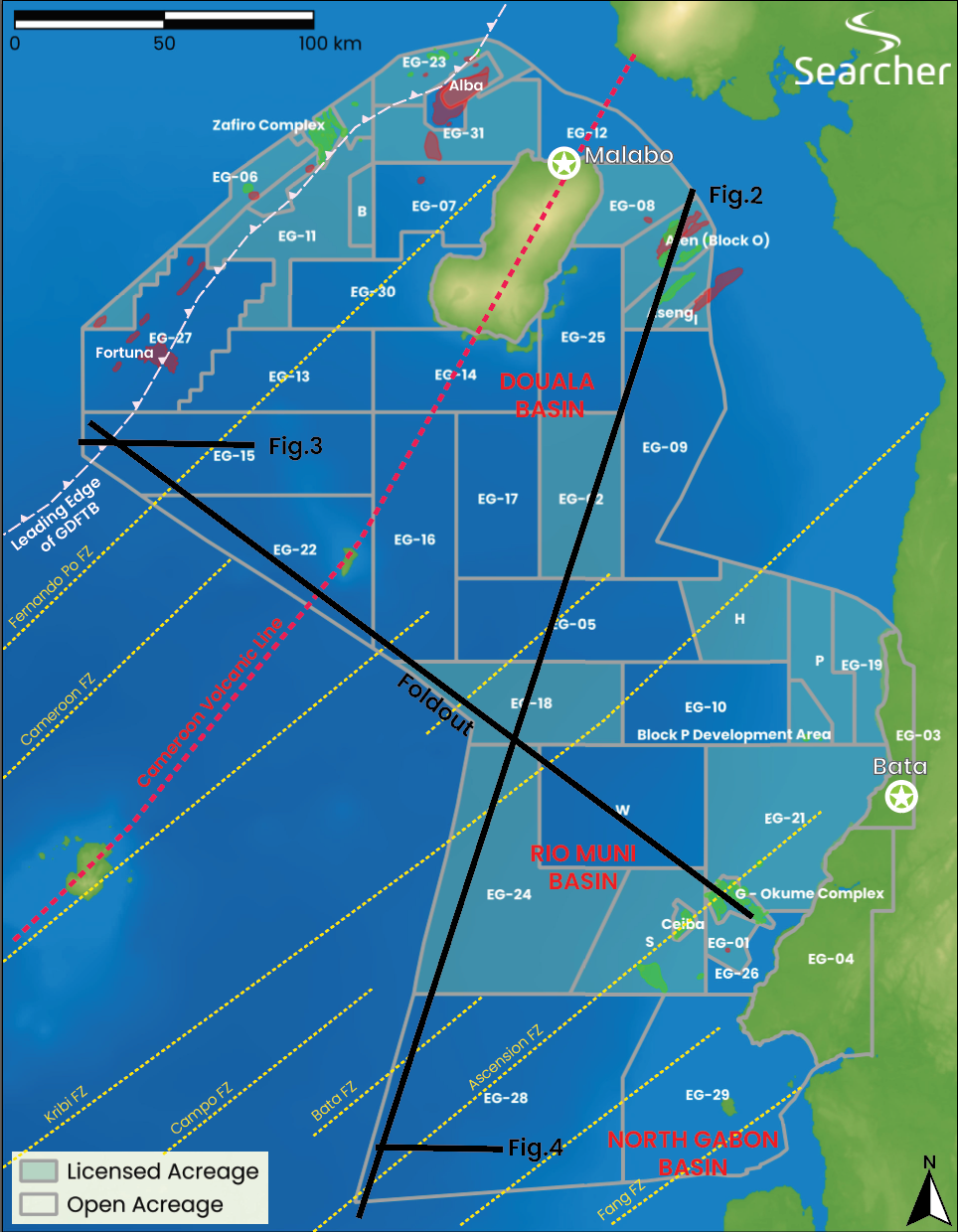
Equatorial Guinea, “EG”, is a unique land in a myriad of ways, with the capital of Malabo on Bioko Island in the middle of the Gulf of Guinea, and an onshore region that lies on the West African coast to the southeast. Malabo lies at the feet of the Pico Basile, an active volcano on the Cameroon Volcanic Line (CVL), a relatively young linear array of volcanoes extending from onshore Cameroon into the Gulf of Guinea. Volcanoes and oil exploration don’t always mix well, but EG is a country where the volcanoes have played a crucial role in creating opportunity.
In the 1980’s exploration in EG was focusing on a Tertiary Gravity Driven Fold and Thrust Belt (GDFTB) that extends East-West near the northern border with Nigeria (Figures 2 and 3). Here, the heads of toe-thrusts form shallow, relatively clearly imaged antiforms in Pliocene to Miocene high-quality sands that were poured south from the Niger Delta. These targets were the low-hanging fruit of the 1980s and 1990s, the time when the giant Alba gas field was discovered. When Mobil discovered the giant Zafiro oil field in 1995, on-trend with Alba’s high-quality Pliocene age sands, it transformed the nation’s economy.
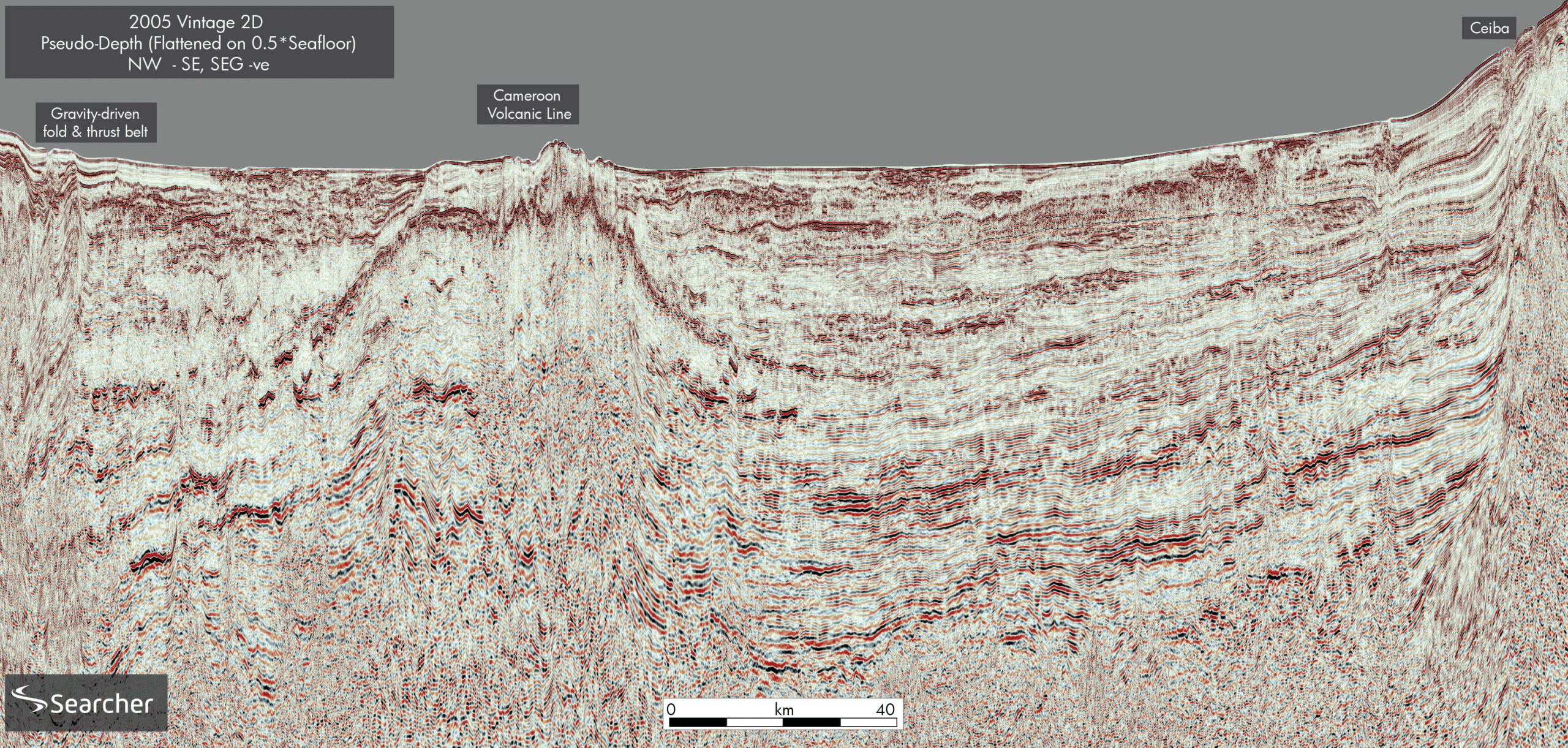
Shortly after the Zafiro discovery in 1999, Triton Energy discovered the Ceiba field in the south of EG’s Duala Basin mainland slope. Again, like Zafiro, this discovery was considered to be in extraordinary water depths at the time for Africa, 600-800 m. As a bellwether of the shape of things to come, Ceiba was brought online incredibly quickly in 2000 by subsea tie-back to an FPSO. The Ceiba field and the adjacent Okume complex of fields, which followed in 2001/2 are mixed structural and stratigraphically trapped channel levee complexes consisting of turbidite and overbank splay sandstones of Campanian age in the upper slope within the Elon and Okume canyons.
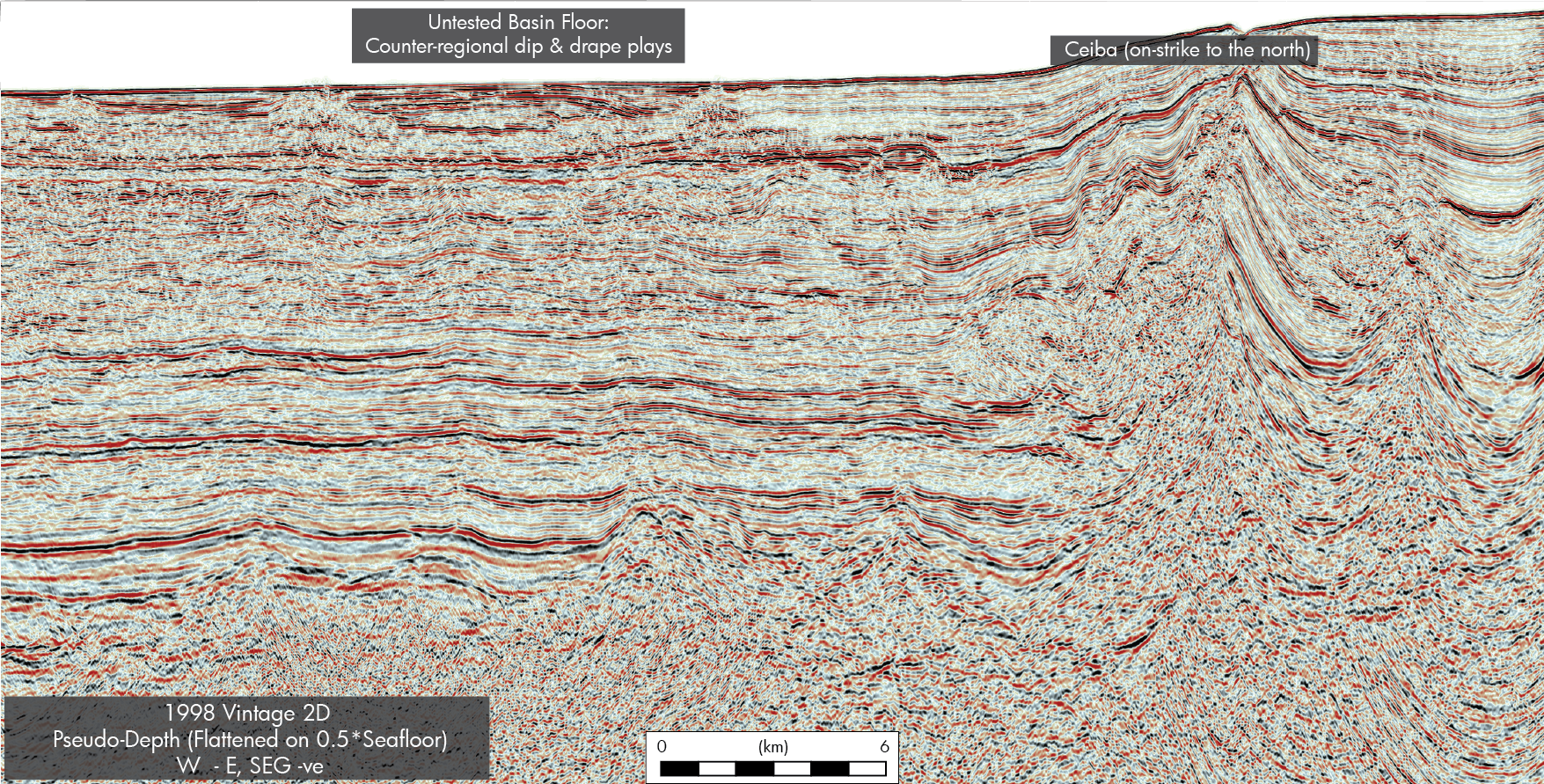
Although stratigraphically deeper targets have now been identified, including Kosmos’ non-commercial discovery in the Albian on the Ceiba block in 2024, in this southern basin, down where the channels meet the basin floor and its counter-regional dipping plays, these fans remain steadfastly untested. Cretaceous sands from the Eastern Duala basin running SW along oceanic fracture zones (just as they do in Benin on the transform margin), and sand coming from the Elon and Okume canyons to the east all end up on the basin floor, draped over oceanic crust blocks or in huge oceanic crust dip plays (Figure 4). This untested southern area is adjacent to where the Jaca well was drilled in 2022, on trend with the fracture zones. Jaca-1 has an additional later sand source from the Ogooue Delta of North Gabon, yet the big play is in the Cretaceous and due to see new exploration drilling Q3/4 2025.
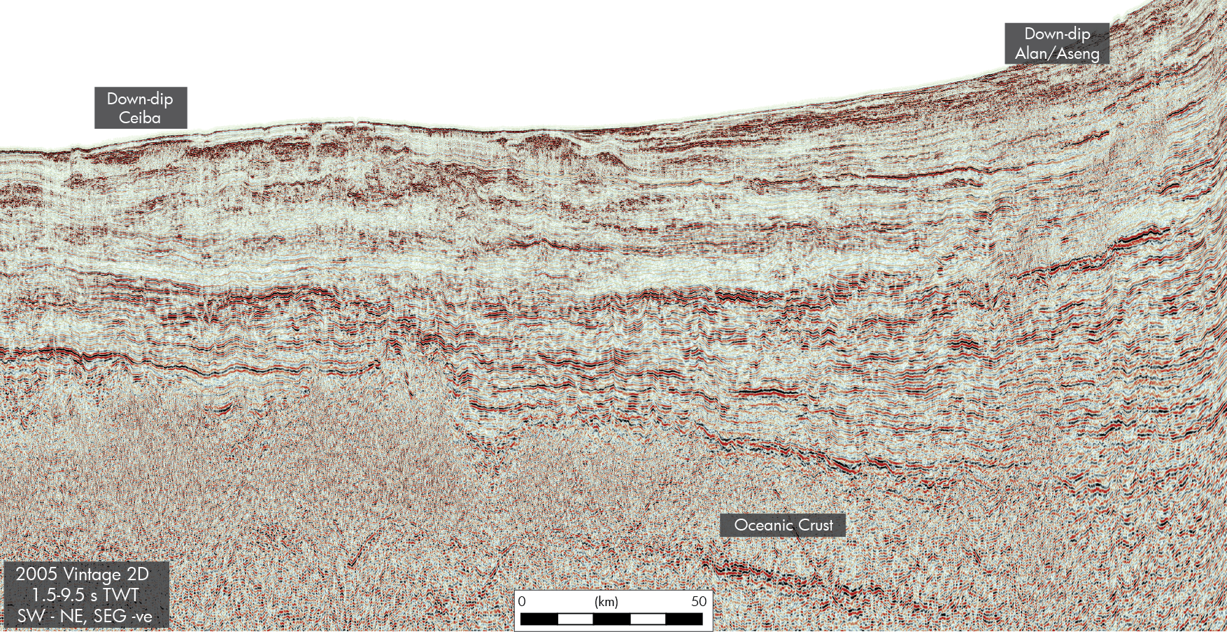
Through the 2000s, some shallow water EG play concepts continued to be defined. The discoveries off the east coast of Bioko Island targeting Miocene sands coming from the northeast in Cameroon are testament to that. The Belinda Aseng, Diega, Felicia and Benita discoveries lie in shallow water (ca 75 m), but they demonstrate that Miocene sands coming into the basin were steered or directed by the ongoing volcanism of the CVL, deforming the basin floor to develop multiple parallel channel systems running NE-SW. However, the idea that the CVL had been there forever, controlling deposition into NW-SE striking depocentres, is unlikely to be correct. The CVL was only emplaced through the Tertiary – implying that Cretaceous turbidites coming from any direction into the basin could now be either side of CVL, where they were guided by topography related to fracture zones on the oceanic crust. This stopped when volcanism started initiating the northern GDFTB. The volcanoes generated basin floor topology or breaks of slope that constrained basin floor channels or moved the slope-breaks causing turbidite flows to drop their coarse clastic load (Figure 2 and foldout line).
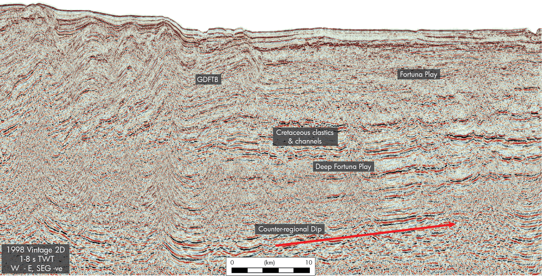
The thrust belt plays on the northern GDFTB border were found and mapped in the 1990. However, it would take another decade before wells were drilled in the GDFTB foreland to the east. In 2006, the chance of finding big oil in the foreland play enticed Ophir to explore the eastern end of the thrust trend. What excited Ophir was a Mid Miocene channel system winding and cutting through the then-growing GDFTB, depositing a large fan in the foredeep (Figure 3). When the Fortuna 1 well was drilled in 1,691 m of water in 2008, it actually encountered a 55 m dry gas column in high-permeability 30+ % porosity sands. The field was appraised, and another similar Mid-Miocene discovery, Viscata, was added to the discovered resource on the block. We understand that a total of ca 4 TCF is now proven, which is considered commercial.
However, Fortuna and the appraisal wells not only confirmed a syn-GDFTB Mid-Miocene play, but crucially also encountered underlying Upper Cretaceous sands that pre-dated the GDFTB. This is a significant observation as it proves that pre-GDFTB and pre-CVL intrusion, offshore EG was a deep basin floor, not only accumulating sands from the NE and SE but also accumulating Cretaceous basin floor fans and aggrading channel systems from the Niger Delta in the north. Don’t doubt that sands can get this far – they are penetrated in the Fortuna wells and comparable to many other examples of sands travelling huge distances, for instance from Senegal to volcanically inverted Maio in the Cape Verde Islands. This is an incredibly important play as the basin’s structural dip caused by the Tertiary CVL puts the Cretaceous basin floor fans into large and as yet untested counter-regional dip traps between the GDFTB and the CVL.
And this perhaps is where the excitement for explorers starts. This is where the time capsule opens. Whilst the industry has been accelerating into commercially challenging water depths off the continental shelf in multiple basins around the world, in EG the deepest water you can find is only 2,200 m, and yet here, the white hot cauldron of pushing the boundaries of exploration and development drilling depths 25-30 years ago, the focus has been mainly on development and not on exploration since 2007.
Equatorial Guinea is a unique country. Its people are unique, the geology is unique, and we can’t think of anywhere with so much open acreage in moderate to shallow water, covered by 3D that is being reprocessed right now to PSDM. In addition, the area has many proven hydrocarbon systems for oil and gas, a sophisticated regulator and existing production. Furthermore, the EG Minister for Energy is reported to be preparing a new acreage access initiative for 2025/6 and this heralds the perfect time for explorers in EG to target big, simple, low-risk, oil and gas prospects using perfect data.
THE BIGGEST LEAP FOR MANKIND
The most rapid advance in geoscience, and our industry, and indeed the biggest technological leap for mankind since Neil Armstrong stepped on the moon in 1969, has been the development of seismic processing technologies over the last 10 years. And here’s the fascinating thing – a lot (although crucially not all) of EG’s open blocks are covered by 3D’s (many post 2000). Yet virtually none of these datasets have been reprocessed since the ubiquitous adoption of deghosting and PSDM technologies about 7 years ago. Therefore, we can confidently expect astonishing uplift from these data in which companies like Searcher and GeoexMCG are currently reprocessing along with regional 2D datasets.


