The author took part in a 10-day industry field trip to study the Huqf and younger exposures in 2011, from which many outcrop photos are used to illustrate this article. Gratitude is extended for knowledge of the stratigraphy and petroleum systems of the Eocambrian, which were determined and published by Shell geologists at the Petroleum Development of Oman (PDO).
Background to the field trip
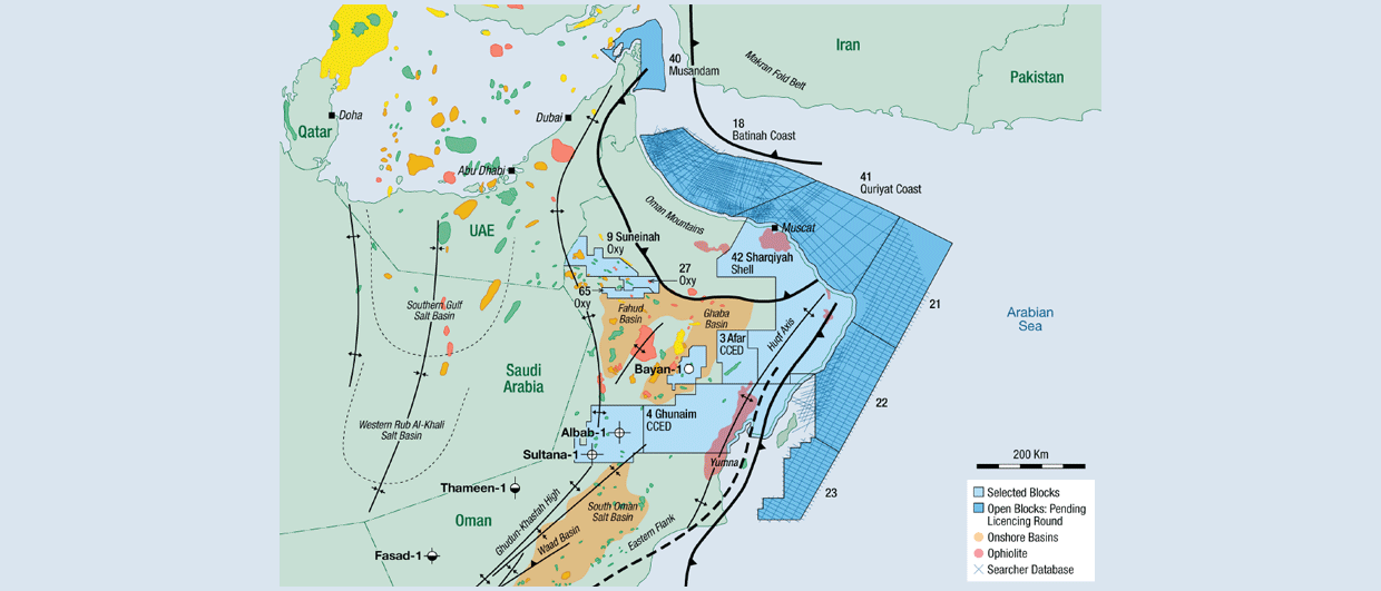
The author was a member of the exploration team at Circle Oil that operated two licences in Oman (2005-2015) with Block 49 onshore and Block 52 offshore (Figure 1a). Both blocks had been poorly explored and calibration of the available seismic to well data and accessible outcrops was essential to refine the interpretation of prospectivity. The field trip to study the outcrops was organised together with former PDO personnel at Shuram in Muscat.

A total of 50 exposures were studied during 10 days in March 2011 in a roundtrip anticlockwise route from Muscat to Salalah inland and returning along the coast to Muscat. Not only was the Eocambrian the subject of this trip, but also all available stratigraphic intervals through the Palaeozoic to the Tertiary to facilitate assessment of the Circle Oil blocks. A stratigraphic chart for southern Oman is shown in Figure 1b) together with some selected oil field occurrences annotated at the appropriate age intervals.
Eocambrian Outcrops and Hydrocarbons
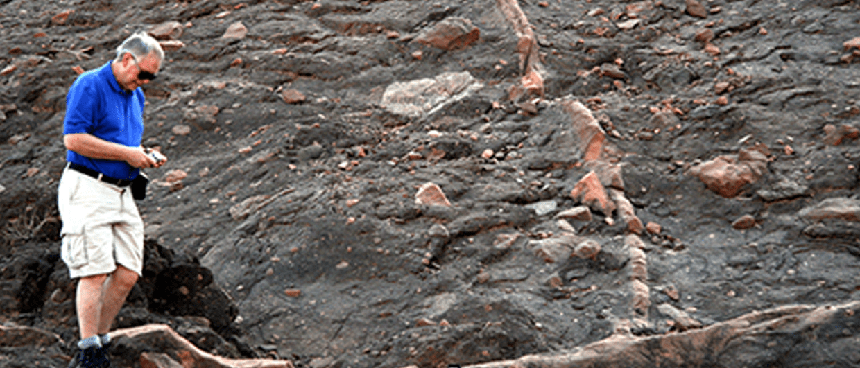
The Huqf Supergroup is extensively exposed in the Huqf Uplift area north and onshore from Masirah Island (Figures 2, 3 and 4). Although the Ara Salt formation is poorly exposed in that area, the older three constituent formation lithologies, significant fossils (dominated by stromatolites from the carbonate units of the Khufai and Buah) and sedimentology are illustrated in Figure 2a. Examples of the variable lithologies of the basal Abu Mahara Group are shown in Figures 2b-i.
The Abu Mahara consists of clastics unconformably overlying older Precambrian crystalline basement (Figure 2f). The depositional environment of these clastics varies from restricted marine, with dark fetid shales of the Ain Sarit Formation (potential source rock, Figures 2g, h and i) through shallow marine to fluvioglacial sandstones of the Mirbat formation. The outcrop of an oil seep in Mirbat Bay (Figure 2b) consists of sun-baked hard black residue coating joints and bedding planes in tight quarzitic flagstones, lying just above the high water mark of the Indian Ocean. The source of the oil is contentious with possibilities of being from the underlying Ain Sarit or from offshore downfaulted Upper Jurassic Sahtan.
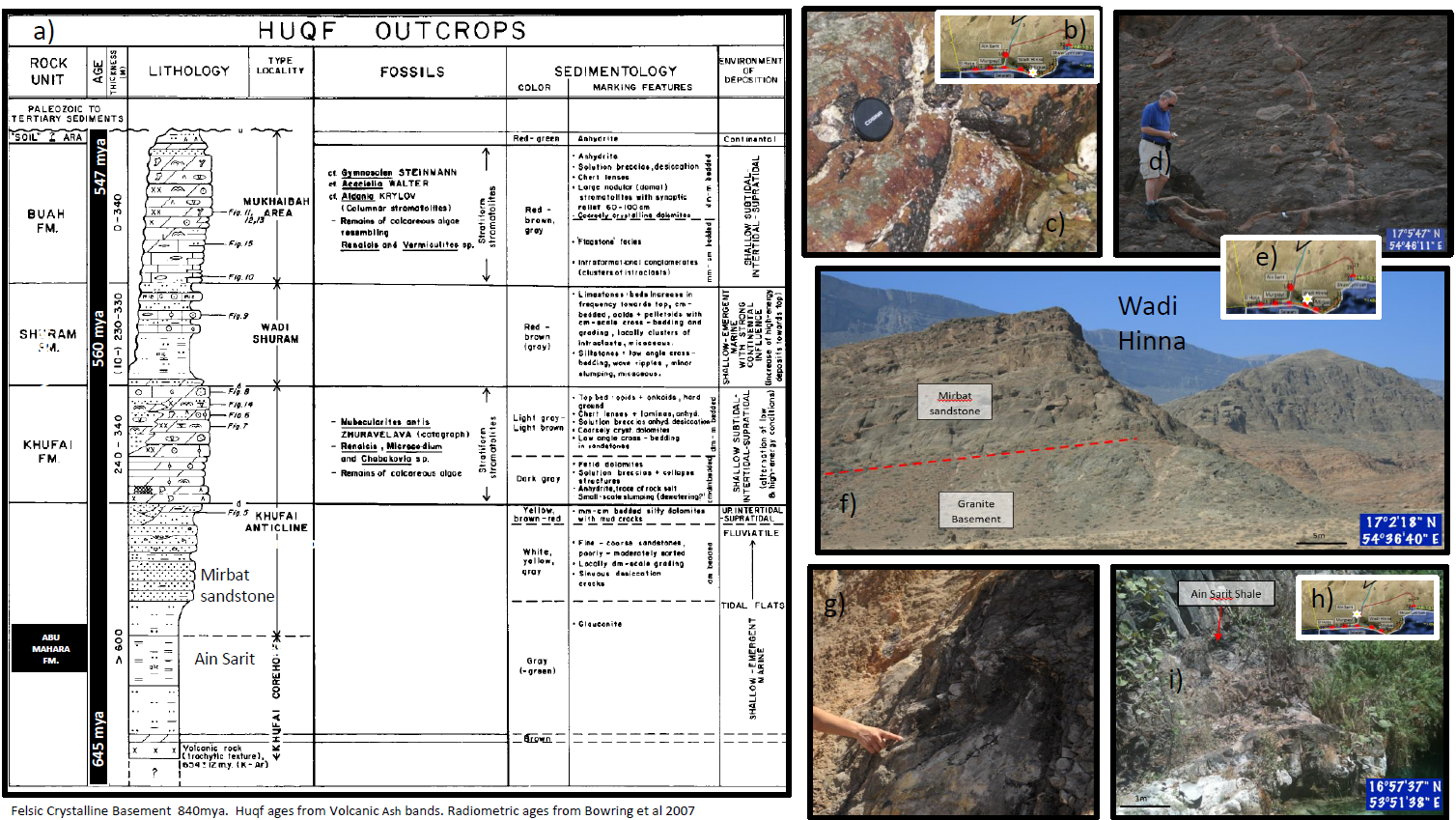
Evidence for an Eocambrian glaciation event is provided by the dropstones of the Mirbat Formation. These are well-exposed in Wadi Hinna, exhibiting several sand injectite features (Figure 2d). However, Mirbat reservoir quality is poor and little evidence of producible hydrocarbons has been documented from the wells that have penetrated the Abu Mahara in Southern Oman.
The Masirah clastics together with the succeeding Nafun Group Buah carbonates, Shuram clastics and Buah carbonates form two successive transgressive/regressive cycles. The Masirah Formation is basically a section of northward prograding clastics. The Khufai and Buah formations consist of northward prograding carbonate ramp in peritidal facies in the Huqf uplift area, which are separated by Shuram Formation storm dominated shelf system of transgressive clastics.
To date, the Nafun Group has been poorly explored for hydrocarbons, although recent discoveries and development in Oman blocks 3 and 4 have been successful (Figure 3a). In that area, south of the Huqf Uplift, the Ara Salt is absent, seismic depth penetration is improved and structural traps with anticlines and tilted fault blocks are relatively shallow and have proven worthwhile drilling targets. The Khufai stromatolitic dolostones are overlain by the Shuram siltstones but truncated at the base Permian over the Huqf Uplift.
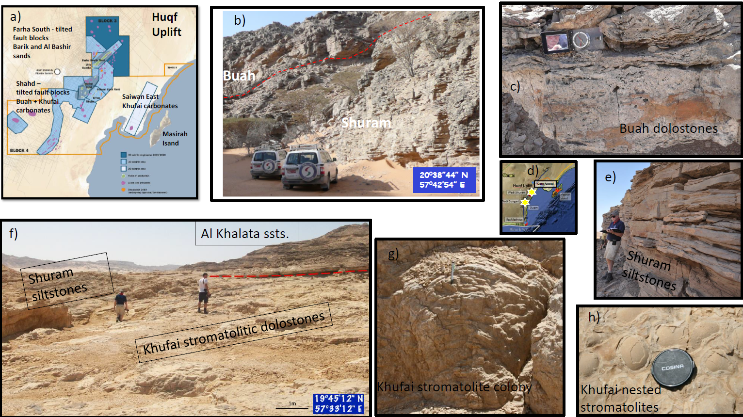
The base of the Al Khalata sandstones forms an angular unconformity onto the underlying Nafun Group at the Wadi Dungart locality shown in Figures 3d and f. Examples of the variety of the stromatolites found in the Khufai are show in Figures 3g and h. The Shuram outcrops largely consist of thinly bedded siltstones and organic rich shales (Figures 2b, c and e). Source rock quality has been identified in the Shuram, but also within the Khufai and Buah. Bitumen-filled vugs and fractures are common in both carbonate units. The Buah dolostones in particular show good visible porosity in outcrops at Qarn Aswad (Figures 3 d and e).
Outcrops of the Ara Salt are rare, but the salt diapir piercement area to the northwest of the Huqf Uplift provides spectacular examples of halokinesis effects (Figure 4). Qarat Kibrit has exposures of the native salt in the core of the piercement (Figures 4 b and c). The salt at surface suffers from dissolution despite the desert conditions and the remnant residual strata consist of rafted carbonate stringers and black organic rich shales (Figure 4d). Good visible pinpoint porosity is present in the wavy bedded dolostones (Figure 4e). An aerial photo of the Qarat Kibrit piercement is shown in Figure 4f.
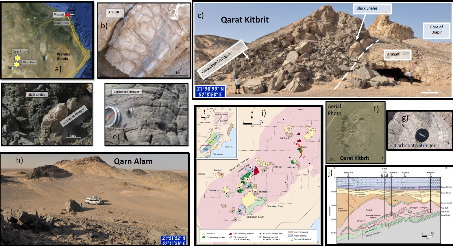
Qarn Alam is a nearby piercement structure (Figure 4h) with excellent outcrops of wavy laminated stromatolitic dolostone (Figure 4g). These carbonate stringers are considered to be rafted into the salt basins from platform areas. This is particularly evident from subsurface interpretation.
The early discoveries of oil reservoired in carbonate rafts within the salt must have come as a bit of a surprise when drilling. The first discovery of Nasir in 1976 was quickly followed by the nearby and on trend Birba discovery. A location map and cross section are shown in Figures 4i and 4j. With improved seismic techniques and in particular 3D acquisition and processing, the identification of the stringers location became easier to define. On seismic, the stringers give the appearance of a string of sausages to the broken continuity of high amplitude carbonate reflections encased in the more amorphous Ara Salt.
An unusual deposit
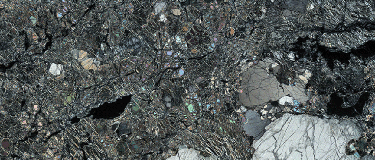
The Ara carbonate platforms are located to the north and south of the centre of the Southern Oman Salt Basin (Figure 5a). Earthquakes are the likely cause for the dislocation of the carbonate rafts that slid into the basin. The deep central part of the Ara basin was the location for an unusual deposit known as silicilyte. This is a chert formed where deep anoxic high organic productivity rich waters mixed with near surface oxic waters in this Eocambrian sea ( Figure 5b). The mixing processed stimulated silica nucleation on organic matter that sank to the bottom where sedimentation was starved. The resultant rock is a microporous micro-laminated chert.
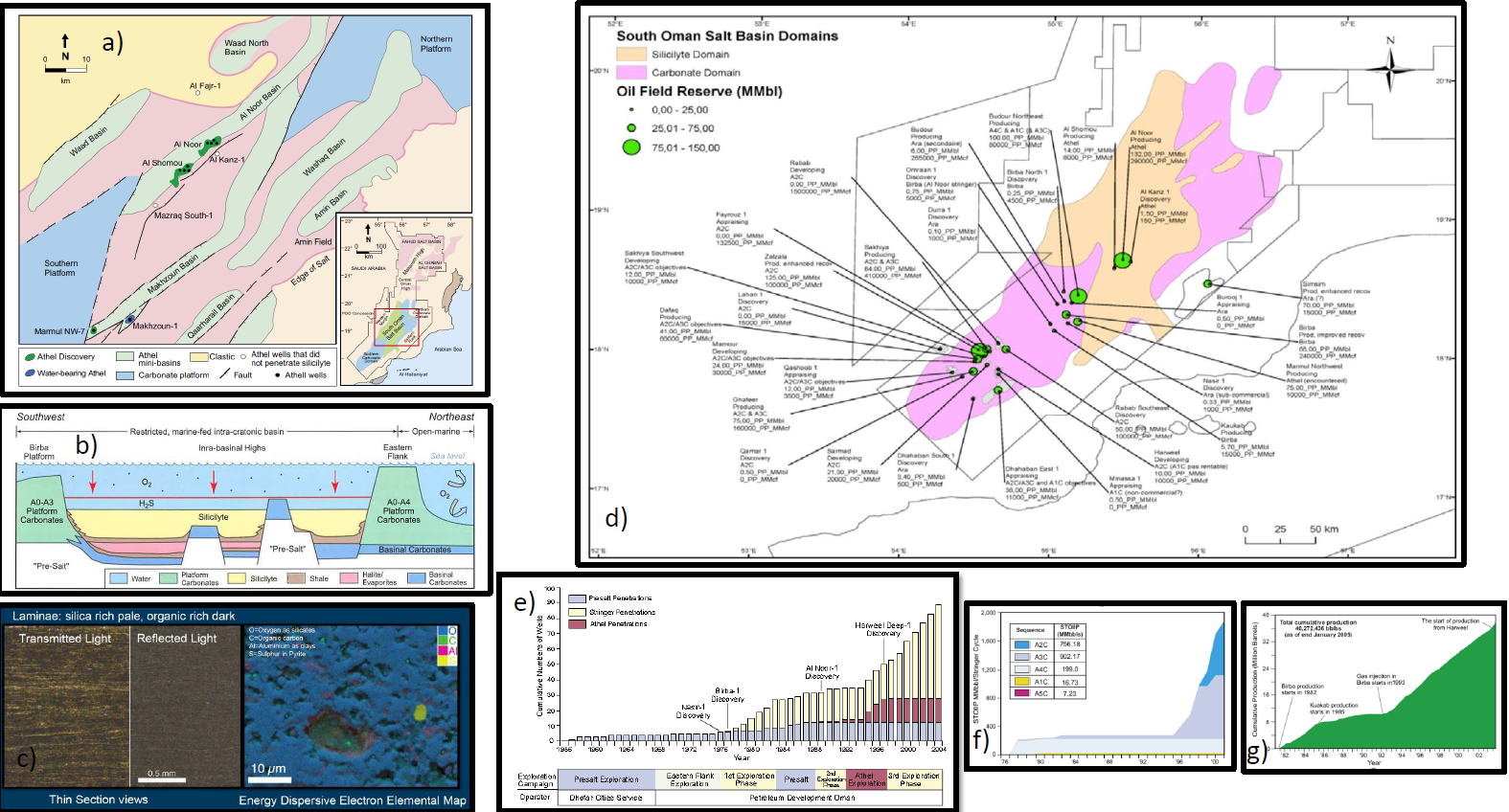
The silicilyte is commonly termed Athel or Shomou after nearby well localities, with a thickness up to 375 m, porosity up to 25%, but low permeability of 0.02 mD. The source interval is overpressured with a total organic carbon content of 4% and largely mature over the basinal area. The crude has an average gravity of 48°API, but sour and primary recovery is only 7-8%, needing massive hydraulic fracing to flow at commercial rates.
The silicilyte is not known to outcrop unfortunately, but thin section photos and an energy dispersive electron elemental map are shown in Figure 5c. The elemental map shows plenty of organic carbon cemented together by silica in the chert.
Exploration success
The success of exploration in the Eocambrian of Southern Oman is shown in Figures 5d to g. The productivity of the Ara carbonate stringers play has led to a renaissance of exploration in Southern Oman, following the original developments in the Carboniferous and Permian such as the Marmul giant field discovered by Cities Service in 1956. Over 1.6 billion barrels of oil-in-place was discovered in the Huqf of Southern Oman from 1997 to 2002.
In summing up, Southern Oman has a wonderful array of outcrops of the Eocambrian and the Huqf, although very old it has proven to be a very productive petroleum system. Reservoirs range in depositional environment from glacial clastics to peritidal stromatolitic carbonates. Petroleum traps range from conventional tilted faut blocks and anticlines, through salt induced anticlines to rafted carbonates and silicilyte. In spite of over 70 years of exploration, there remain many opportunities to discover additional reservoirs and traps.
Well worth a trip sometime soon!
References
Al Siyabi H. A., 2005. Exploration history of the Ara intrasalt carbonate stringers in the South Oman Salt basin. GeoArabia v 10, p. 39-72.
Bowring S. A., Grotzinger J. P., Condon D. J., Ramezani J, Newall M. J and Allen P. A. 2007. Geochronologic constraints on the chronostratigraphic framework of the Neoproterozoic Huqf group, Sultanate of Oman. American Journal of Science v307 (10), p. 1097-1145.
Despinois F., 2013. Intra-Salt Stringer Play in Oman. Angola salt Conference Proc. p. 33-39.
Gorin G. E., Racz L. G. and Walter M. R. 1982. Late :Precambrian-Cambrian Sediments of Huqf group, Sultanate of Oman. AAPG Bull, v 66, No. 12, p. 2609-2624.
Peters J. M., Filbrandt J. B., Grotzinger J. P., Newall M. J., Shuster M. W. and Al Siyabi H. A. Surface-piercing salt doles of interior North Oman, and their significance for the area carbonate ‘stringer’ hydrocarbon play. GeoArabia v 8, no. 2, p. 231-270.
Stolper D. A., Love G. D., Bates S., Lyons T. W., Young E., Sessions A. L. and Grotzinger J. P., 2017. Paleoecology and palaeoceanography of the athel silicilyte Ediacaran-Cambrian boundary, Sultanate of Oman. Geobiology v 15, p. 401-426.