State-of-the-art imaging and visualisation techniques that enhance the experience of seismic interpreters and reveal more geological information in the subsurface.
The realm of seismic interpretation has now undergone several decades of technological advancements and improvements. The days of interpreting on long hard copy seismic lines and the art of hand contouring are memories, having given way to the numerical revolution and the arrival of large 3D seismic volumes and their representations managed in dedicated interpretation software.
A series of on-the-fly trace attributes displayed on a 2D line set from the Taranaki Basin, offshore New Zealand. From left to right these show the seismic signal; the dominant frequency; the sweetness; and the RMS amplitude. © Eliis.
The underlying goal of these improvements has been to help interpreters efficiently process increasingly larger quantities of data, supported by optimised tools that can help interpreters make more accurate maps. In particular, a significant amount of effort has been placed on how a software displays data, driven not by pure aesthetics. In fact, this effort stems from the realisation that the interpreter must truly understand the data in order to gain a natural and comprehensive understanding of the information available within it. Although, strictly speaking, the seismic realm does not relate to the centre of the Earth, it is still the reflection of a buried world, and the objective of any interpretation software should be, through its imaging techniques, to help unlock the secrets of this world and display them in vivid reality.
In the modern world, we must acknowledge that most seismic interpreters are still bound to the 2D dimension of their screens. With this in mind, in this article we present a few concrete techniques that are known to greatly enhance the experience of seismic interpreters.
Instantaneous Perspective
It is useful to view a variety of seismic attributes to better understand the geophysical signature of the data prior to starting an interpretation project. For example, an interpreter may want to enhance the detection of structural discontinuities with structural attributes, or to gain insight into the geological organisation of the deposits with stratigraphic attributes. The latter attribute type mostly corresponds to trace attributes and since the computation of trace attributes is simple, it would be wise to take advantage of that fact to display them ‘on-the-fly’, thus allowing the interpreter to instantly put the data into perspective. These attributes should be easily accessible, no further than a pull-down menu, and its availability immediate.
While on-the-fly attributes are useful prior to interpretation, they are also a powerful tool while prospecting when coupled with co-rendering and crossplotting techniques. As co-rendering involves blending several attributes, an on-the-fly display quickly offers a look at a series of trace attribute combinations without having to physically compute the corresponding volumes.
A Bright and Comprehensive Picture
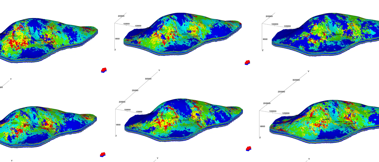
At an advanced stage of interpretation, when a target is being refined, an integrated and detailed analysis of the seismic data is beneficial. One especially powerful technique involves mapping an RGB blend onto a dense series of structurally accurate data-derived horizons, i.e., a horizon stack. The RGB blend, derived from selected frequencies (or frequency ranges), helps to reveal singular geological structures or the extent of depositional environments. This rich blending of colour helps to highlight the complex arrangement of specific lithofacies. To avoid the creation of erratic blending, the software design must include a convenient representation of the spectral decomposition or amplitude spectrum to allow the interpreter to easily select relevant frequencies or frequency ranges, respectively. Hence, an RGB blend mapped onto a dense horizon stack represents a compelling tool to scan an interval of interest and to identify previously ignored targets.
From spectral decomposition to RBG blending on a dense series of geological horizons. From left to right: seismic inline showing a potential target; a dynamic and synchronised spectrogram showing a spectral decomposition in Short Time Fourier Transform and three target-representative frequencies; the RGB blending of the three frequencies mapped on a dense series of horizon slices in the Exmouth sub-basin (North West Australia margin). © Eliis.
Flying Through the Data
From the start of a project to the final deliverables, it is essential for an interpretation software to offer an interactive, user-friendly interface. In this world of XL monitors and the desire to have all available data types, including seismic, attributes, horizons, faults, well logs and markers, displayed in multiple viewers, software designers should put a specific effort into facilitating the interpreter’s cognition. This can be achieved by managing spatial visualisation with the synchronised navigation between the viewers and dimensions. For example, a user interpreting a seismic line should be able to place a tracker at a given location and immediately be able to see the same position in a 3D viewer, where well trajectories and markers would be displayed. Furthermore, for the sake of cognition, he or she should also be able to drag the tracker along the line(s) and continuously follow its position on all viewers when navigating through the data.
A synchronised interface: all dimensions and data are spatially connected to allow for intuitive and rapid navigation through all stages of the workflow. © Eliis.
The advantage of this synchronisation, which is maintained during navigation and applied to all objects, is enhanced further by a smart interface with options like a synchronised scaling display and the ability to quickly synchronise colour bars, thus allowing for consistent analysis. Intuitive interaction between the database and the viewers is likewise enhanced via the use of a drag and drop option. In the end, this interaction should draw the interpreter intuitively and swiftly nearer the position of a geologist in the field, with the added benefit of using the whole potential of the available database.
What’s Next?
We have seen that, if used properly, these visualisation and imaging techniques increase efficiency and have a positive effect on a user’s experience throughout the seismic interpretation workflow, thus helping to unravel the potential of what lies underground. As we believe these techniques will become the standard or norm for modern seismic interpretation software, the question becomes: what’s next? Should we seek for the massive development of augmented reality and immersive technologies, allowing users to set foot upon a virtual paleo-scene as a geologist would tromp through a gigantic outcrop – but without the gear? Should we strive to use restoration to interactively see time roll back before our eyes, unearthing the buried world with its diversity of depositional environments? This, I guess, only the future can tell.
Acknowledgements
The title of the print version of this article (A Journey to the Centre of the Earth) is inspired from the novel of the same name by Jules Verne, first published in 1864. The examples presented were obtained using PaleoScan™, software developed by Eliis. The author would like to thank New Zealand Petroleum & Minerals and the Government of New Zealand for their permission to publish the 2D data from the Taranaki Basin; Geoscience Australia and the Government of Australia for block HCA2000A (Exmouth); and TNO and the Dutch government for the authorisation to publish their data on the block F03.
Further Reading from Eliis on Seismic Interpretation in Paleoscan
Reservoir Model Gridding: Bridging Seismic Interpretation & Reservoir Modelling
Sven Philit, Agathe Carbonie, Fabien Pauget, Eliis; Vianney Savajol, Eliis Inc.
Geoscience software that bridges seismic interpretation and reservoir modelling with the generation of a geocellular grid – accurately delineating the geometries of the geology.
This article appeared in September, 2019
One Step Closer to Fully Automated Fault Extraction in 3D Seismic Data
Sven Philit, Fabien Pauget, Sebastien Lacaze; Eliis, Caroline Guion; Eliis Inc.
To boldly go where no interpreter has gone before, getting one step closer to achieving the fully automated detection of faults in 3D seismic data.
This article appeared in Vol. 16, No. 1 – 2019
Shaping the Future of Seismic Interpretation
Vianney Savajol, Eliis, Houston
A quicker way from seismic data to geomodel – or how seismic interpreters have finally come to the centre of the exploration workflow.
This article appeared in Vol. 14, No. 3 – 2017