“If we can’t discuss uncertainty, we won’t go anywhere.” Geothermal Radar’s co-founder Philip Ball is adamant about what is currently lacking in the planning of new geothermal exploration wells. “Where oil charge, migration and trapping are key factors in hydrocarbon exploration, the temperature at target depth is one of the most important drivers for the success of a geothermal project,” he says.
“However, from what I have seen, often there is no proper uncertainty assessment when it comes to the expected temperature range,” says Philip when we meet on Teams. “And that is odd, because there is a lot of uncertainty and there is always a significant financial investment at stake when drilling a new well!”
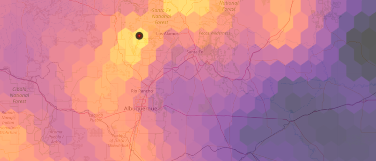
Philip shows me a location somewhere on the globe in his newly launched Geothermal Radar platform from which he’s got a range of temperature models predicting what the likely subsurface temperature profile will be. “As you can see,” he adds, “each of these models predicts a slightly different outcome, which is testament to the various input parameters used for each individual model. Having a better understanding of the range in outcomes will improve our ability to plan for a drilling project.”
Philip is not new to subsurface models. He worked in oil and gas for a good number of years, where he was widely known as a rifted margin and plate tectonic specialist, looking at large-scale basin models. Temperature data were part and parcel of those basin models, but in those cases more from a hydrocarbon maturation point of view. “When I saw a new seismic line,” Philip says, “I always checked for the Moho first!”
During those years, Philip’s hobby was to seek out published lithospheric and isotherm models, even without a plan in place with what to do with it. This changed when he started doing an MBA, during which he chose to do his topic on geothermal energy.
“I decided to bite the bullet and started to integrate the temperature models and data in a global platform, with the vision that individuals and companies can quickly assess the range of temperature predictions for the areas they are interested in. Ultimately, we want people to produce a P10-P90 range of expected temperatures,” he adds.
With his co-founder, Vladimir Stroganov, they are optimising Geothermal Radar to be a single platform for energy companies, investors, the industry and even national authorities. “We are already engaging with quite a few oil and gas majors interested in geothermal energy,” says Philip, “with the aim to integrate our techno-economic & temperature models with their proprietary data and 3D basin model outputs.”
And while Geothermal Radar is now live, Philip keeps on adding new data and cutting-edge models all the time, working with researchers at Twente University in the Netherlands and Keele University in England. “I’m also very much into continuing research, such as the question where we can find those temperature nuggets that are normally only in our P10 range,” Philip explains.
“Ultimately,” he concludes, “we’re not just providing another mapping tool, we’re giving companies the confidence to make better exploration & drilling decisions by quantifying uncertainty. As such, the analysis isn’t just academic – it is essential for commercial success.”