3D seismic risk reduction for license round
Phillip Hargreaves
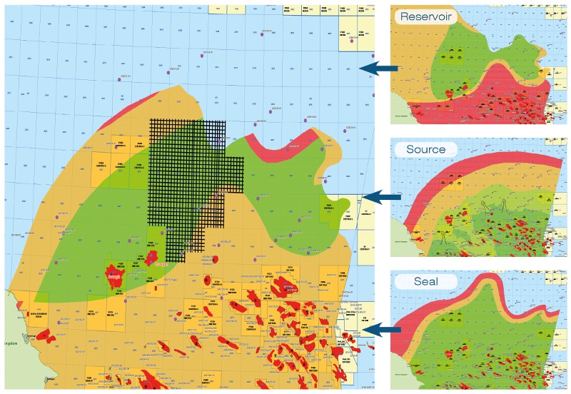
On Australia’s North West Shelf, acreage in shallow water multi-TCF neighborhoods is highly prized and competitively sought. To assess the value of acreage for optimum license round bidding requires investment in detail, to reduce risk and support confident, intelligent action.
The North West Shelf is characterized by frequent licensing rounds, and very rapid development of play ideas by explorers who need to outcompete. Rapid adoption of new imaging technologies supported the exploration for deeper, older reservoirs such as the Lower Jurassic of the Crown, Bassett West and Lasseter (2014) discoveries. The key to imaging and chasing this play is the availability of modern 3D data, and extrapolation from offset well success into unlicensed acreage.
In the Browse Basin to the west of the Ichthys and Prelude LNG projects, 3D data acquired in 2013 covers both the Lasseter discovery and open acreage in the current license round. This 3D images both extensional fault block plays and associated drape structures in which Jurassic and Cretaceous-aged sediments form the primary reservoirs.
When combined with additional 3D coverage over the wider Browse Basin, this dataset presents an essential evaluation tool to support a confident bidding strategy for acreage and subsequent exploration and development activities. Significant remaining prospectivity in the area is present, only fully realized with modern seismic data.
The Final New Frontier
Neil Hodgson
One of the main deepwater plays targeted by exploration companies in the past decade has been to chase sands deposited in canyons running down into passive margin basins. Inherently risky, with the potential for up-dip leakage below the resolution constraints of seismic to image, and often small in volume, such exploration in deepwater has brought mixed success and a degree of indifference from the industry.
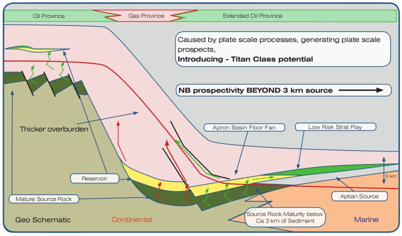
However, the journey into deepwater isn’t over; yet in the new frontier beyond 3,000m water depth lies the real prize: the basin floor fans that provide prospects ten times bigger and at a third of the risk of the constrained canyon plays. Here, ‘new’ seismic steps up to the plate: long streamer 2D data, processed in the time (PSTM) and depth (PSDM) domains with new techniques to eliminate multiples (SRME) yield a secret big enough to kick ‘Peak Oil’ back onto the fiction shelf. In many places along the Atlantic passive margins, plate cooling and loading has depressed the landward margin, so up-dip trapping is guaranteed – outward from the coast (also see ‘hotspot’ map, above). Structures like these, with zero up-dip risk and oil prone (the source has less burial cover) are present on both Atlantic margins. They form a suite of the biggest as-yet unexplored prospects in the world, affectionately referred to as ‘Titan Class prospects’.
Seismically driven new play in Mature Basin
Karyna Rodriguez
The UKCS Southern North Sea has two major mature plays simply defined by the distribution of Permian and Carboniferous gas fields. North of these, beyond the Rotliegendes pinch-out, exploration of the Carboniferous was hampered by poor seismic data, yet the successful appraisal of the early Carboniferous Breagh Field in recent years indicated that a greater game was afoot.
New seismic acquired in 2013 with long record length has been combined with an innovative processing methodology (delayed-start SRME at Top Chalk level, dual domain Tau-P Decon and high resolution radon), which has re-invigorated the area as for the first time it allows the intra- Carboniferous to be evaluated. An Early Carboniferous Dinantian play fairway analysis evolved from this seismic acquisition, extending the limits of established fairways and developing new untested fairways.
Further north, in areas where the Zechstein top seal thins, hydrocarbons migration from the Carboniferous section up into higher stratigraphic levels can be investigated now via AVO/AVA analysis, illuminating a strong relationship between migration windows and overlying Triassic Bunter Sandstone, Lower Cretaceous Sandstone and Chalk plays (see examples in ‘hotspot’ map, above)
Hi-Tech seismic in a Frontier Basin
Ashleigh Hewitt
If you could choose where to work where would it be? Obviously some sun-kissed shores rather than in yet another rain-drenched English summer at best. Recent good quality seismic surveys and targeted reprocessing have opened up the potential in areas such as
Barbados and the Seychelles, making the choice possible!
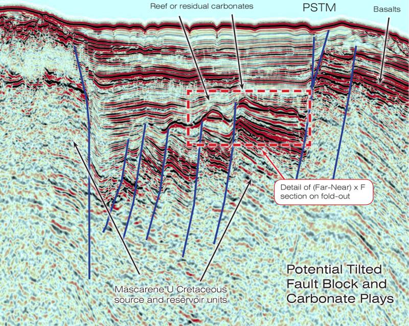
In the Seychelles, recent good quality seismic surveys and targeted reprocessing is identifying hydrocarbon traps and accumulations missed in early reconnaissance.
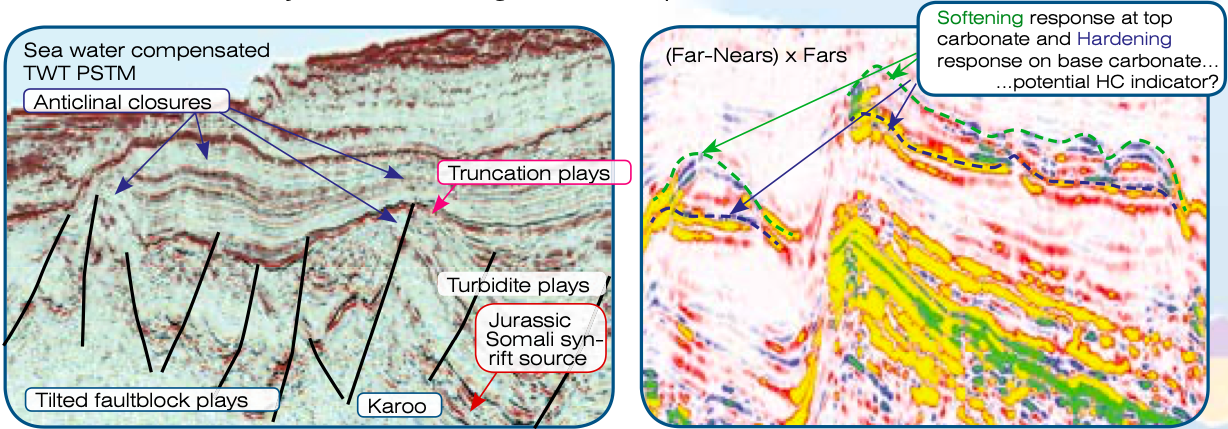
In the ’80s and ’90s the four wells drilled in the Seychelles proved source and reservoir rocks but only oil shows were encountered. This lack of success was in part a result of inadequate seismic resolution making it difficult to reveal the best place to drill and understand possible trap-breach mechanisms. However, there is no doubt the hydrocarbon system is proven, with tar balls and seeps typing to prolific Jurassic Somali-rift and Cretaceous/Paleocene shales. With longer offset seismic and new processing techniques, oil hunters have returned to better define leads of giant proportions. The use of angle stack data is also proving to be invaluable. For example, evidence of dimming on the far angles at the top of a possible reef and brightening at the base could be indicative of hydrocarbons (see ‘hotspot’ map, above). Additionally, initial results from ongoing reprocessing using broadband processing and PSDM suggest even better definition of deeper potential targets in and around the Seychelles Platform and Mascarene Plateau.